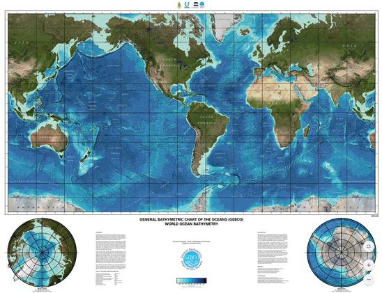
The GEBCO_2023 Grid - A Continuous Terrain Model Of The Global Oceans And Land
--
https://doi.org/10.5285/f98b053b-0cbc-6c23-e053-6c86abc0af7b <-- shared open data library access
--
#GIS #spatial #mapping #opendata #world #global #seafloor #GEBCO #NipponFoundation #bathymetry #remotesensing #topobathy #hydrospatial #ocean #grid #raster #survey #topography #elevation #terrainmodel #GlobalMapper #gischat #crowdsourced #seabed2030
GEBCO - General Bathymetric Chart of the Oceans | The Nippon Foundation
--
https://doi.org/10.5285/f98b053b-0cbc-6c23-e053-6c86abc0af7b <-- shared open data library access
--
#GIS #spatial #mapping #opendata #world #global #seafloor #GEBCO #NipponFoundation #bathymetry #remotesensing #topobathy #hydrospatial #ocean #grid #raster #survey #topography #elevation #terrainmodel #GlobalMapper #gischat #crowdsourced #seabed2030
GEBCO - General Bathymetric Chart of the Oceans | The Nippon Foundation