* Pesquisa sobre o #OSM *

Artigo interessante sobre questões de qualidade nas microtarefas do #Taskingmanager #OpenStreetMap, que analisa as distorções nas bordas e entre as tarefas, decorrentes de práticas cartográficas pessoais. Dois aspectos bem conhecidos, aqui quantificados.
Não estou tão convencido quanto a outras constatações ou a algumas das estratégias propostas para resolver esses problemas. Escreverei um post no blog em breve.

https://onlinelibrary.wiley.com/doi/10.1111/tgis.70288

* Research on OSM *

An interesting article on quality issues related to #Taskingmanager #OSM microtasks, which analyze distortions at task boundaries and between tasks caused by individual mapping practices. These are two well-known issues, now quantified here.
I am less convinced by other findings or by some of the proposed strategies for resolving these issues. I will write a blog post about this soon.

https://onlinelibrary.wiley.com/doi/10.1111/tgis.70288

* Recherche sur OSM *

Article intéressant sur les questions de qualité sur les micro-tâches du #Taskingmanager #OSM qui analysent les distorsions sur les bords et celles entre les tâches, en raisons de pratiques cartographiques personnelles. Deux aspects bien connus, ici mesurés.
Je suis moins convaincu par d’autres constats ou sur certaines des stratégies proposées pour résoudre ces problèmes. J’en ferai un billet de blog prochainement.

ttps://onlinelibrary.wiley.com/doi/10.1111/tgis.70288

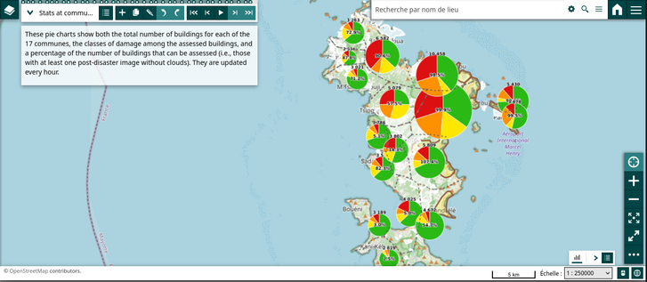
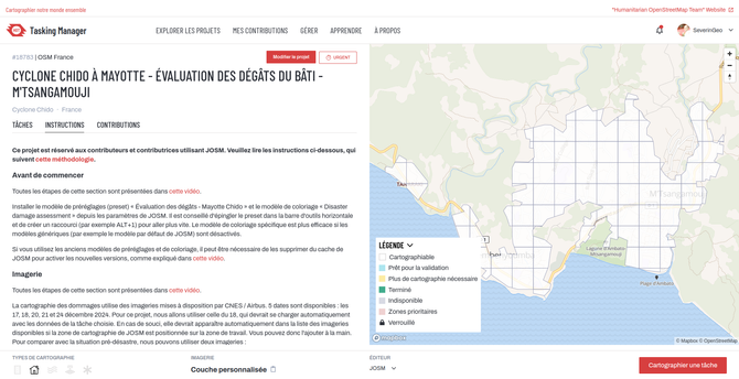
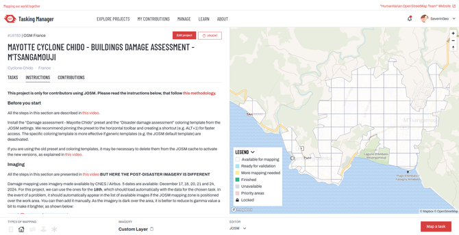
Depuis juin, dégâts bâtiments dus à cyclone #chido à #mayotte cartographiés dans #josm à Sada, Trévani, M'Tsangamboua, M'Tsahara, M'Tsangadoua, Bouyouni, Longoni, Tanganin, à l'aide imagerie post-désastre #Disastercharter.
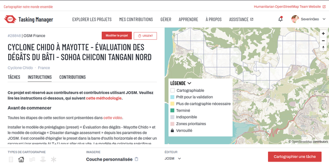
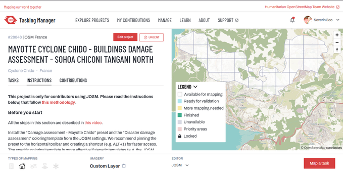
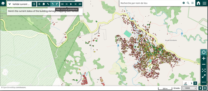
Vahibé achevé hier et un nouveau projet @[email protected] #taskingmanager démarré au nord de Sohoa, Chiconi et Tangani, situés à l'ouest de l'île principale. Objectifs : montrer efficacité de #openscience + laisser #openstreetmap #osm #opendata complète comme trace du désastre.
Since June, building damage after cyclone #chido in #mayotte has been mapped in #josm over Sada, Trévani, M'Tsangamboua, M'Tsahara, M'Tsangadoua, Bouyouni, Longoni, Tanganiin, using #Disastercharter post-disaster imagery and providing #openstreetmap #osm.
Vahibé has been achieved yesterday and now new @[email protected] #taskingmanager project started over north Sohoa, Chiconi and Tangani, located in the west of the main island. Aim: showing effective #openscience + let complete #opendata of the event

Good news everyone!

The embedded iD and Rapid editors on https://tasks.openstreetmap.us/ and https://tasks.teachosm.org/ have been updated to more recent versions (2.34 and 2.5.3 respectively).

Thanks to @jakelow for keeping things rolling along!

#taskingmanager #openstreetmap #teachosm #rapid #id

OSM US Tasking Manager

Collaborative mapping for public good.

OSM US Tasking Manager

令和7年8月6日からの低気圧と前線による大雨の災害について多くの情報をいただき、クライシスマッピングプロジェクト第二弾として熊本県八代市のプロジェクトを公開しました。順次対象エリアを拡大していきます。

主に、建物と道路マッピングになります。
今回は Bing 航空写真をデフォルトにしていますが、位置がズレている箇所もありますので、マッピング前に国土地理院の地図や航空写真に合わせてBingレイヤをオフセット補正をしたうえで、マッピングをよろしくお願いします!

Heavy Rain in Kyushu Island, 2025 Building and Road Mapping. Yatsushiro, Kumamoto, Japan
tasks.hotosm.org/projects/27198

#TaskingManager #CrisisMapping #HOTOSM #DRONEBIRD #OSMjp #OpenStreetMap #FuruhashiLab #古橋研究室 #AoyamaGSC #青学 #GEOlab #PoliMI

令和7年8月6日からの低気圧と前線による大雨の災害について多くの情報をいただき、クライシスマッピングプロジェクト第一弾公開しました! 順次対象エリアを拡大していきます。

主に、建物と道路マッピングになります。
霧島市内の国土地理院航空写真は撮影年が古かったので、今回は Bing 航空写真をベースにマッピングよろしくお願いします!

Heavy Rain in Kyushu Island, 2025 Building and Road Mapping. Kirishima, Kagoshima, Japan
https://tasks.hotosm.org/projects/27165

#TaskingManager #CrisisMapping #HOTOSM #DRONEBIRD #OSMjp #OpenStreetMap #FuruhashiLab #古橋研究室 #AoyamaGSC #青学 #GEOlab #PoliMI

Après Mamoudzou, Tsingoni, Bandraboua, M'Tsamboro et Acoua, M'Tsangamouji dans le nord-ouest de Grande-Terre est le nouveau projet @[email protected] dans le #taskingmanager pour cartographier dans #josm #openstreetmap les dégâts des bâtiments après le cyclone #chido à #mayotte en utilisant l'imagerie post-catastrophe de @CopernicusEU.

Nous manquons de volontaires, n'hésitez pas à venir ce jeudi apprendre une cartographie différente sur #osm ! https://osmcal.org/event/3673/

Atelier - mapathon: évaluation post-cyclonique des dommages aux bâtiments

Atelier - mapathon: évaluation post-cyclonique des dommages aux bâtiments, 24th April 19:00 – 21:00 (Africa/Dakar) . L'événement sera à la fois un atelier (car il montrera la méthodologie pour cartographier les…

OpenStreetMap Calendar
After Mamoudzou, Tsingoni, Bandraboua, M'Tsamboro and Acoua, M'Tsangamouji in the northwest of Grande-Terre is the a new @[email protected] project in the #taskingmanager to map #josm #openstreetmap #osm building damage after cyclone #chido in #mayotte using @CopernicusEU post-disaster imagery.