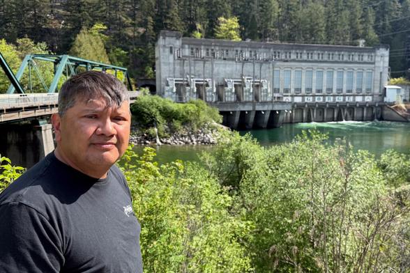
Want to spend your evenings and weekends this summer in Seattle learning to be a small farmer? The Viva Farms practicum school is having its open houses on Feb. 3rd. One in Mount Vernon and one in Woodinville.

https://vivafarms.org/practicum-in-sustainable-agriculture-2/

#seattle #skagit #marketGardening #sustainableFarming #GardenVegetables

Practicum in Sustainable Agriculture | Viva Farms

@erl Grumble grumble symmetric encryption and no forward secrecy.

But I’m working on getting more #Meshtastic devices up in #skagit north of #seattle

Hype for the Future 78M: City of Mount Vernon, Washington

Overview The City of Mount Vernon is located on the north side of the Greater Seattle area in the Pacific Northwest to serve as the county seat of Skagit County, Washington, in the United States. The most notable feature of Mount Vernon is the Skagit Valley Tulip Festival; however, as with a number of communities of similar size within the State and into Oregon, the community is also home to a number of art galleries within the general downtown area.

https://novatopflex.wordpress.com/2026/01/17/hype-for-the-future-78m-city-of-mount-vernon-washington/

Hype for the Future 78M: City of Mount Vernon, Washington

Overview The City of Mount Vernon is located on the north side of the Greater Seattle area in the Pacific Northwest to serve as the county seat of Skagit County, Washington, in the United States. T…

novaTopFlex

It’s adorable seeing NYTimes interleave conversations with folks at the #Snohomish River, right snug along the northeast of the Seattle metro, with folks along the #Skagit, up 75km north. But I guess the distance between Boston & Providence clearly isn’t worth making clear.

https://www.nytimes.com/2025/12/11/weather/washington-flooding-rain-atmospheric-river.html

#Cascadia #SalishSea

100,000 in Washington State Ordered to Evacuate as Rivers Rise

Days of heavy rain pushed waterways to record flood levels in a mountainous region north of Seattle. “Do not wait,” local officials warned residents, urging them to seek higher ground.

The New York Times

#WAwx #Flooding #Skagit #Snohomish

From The Seattle Times.com: Live: Flooding in WA’s Skagit, Snohomish rivers prompts road closures, evacuations | The Seattle Times

https://www.seattletimes.com/seattle-news/weather/wa-floods-road-closures-and-evacuation-order-in-skagit-flood-plain/

Light brown area on this map marks the 100 year flood plain for the Skagit River in Washington State. #Skagit County officials have ordered everyone in that flood plain area to evacuate. Local news estimates that is around 70,000 people.

The red hash marks on the map are levees.

Zoom in on the map and you will see that most of the town of Burlington has been ordered to leave.

The river is now forecast to reach a new record high of about 38 feet at approximately 4am Friday. This at the streamgage (triangle) that is near the center of the map when it opens.

If you click a streamgage then you will see a popup. Scroll down in that popup display for 2 links to graphs with near real time water levels. Caution! The first graph is a worst case. The second graph shows probabilities that the water will get to different levels.
#PNW #WAwx #Seattle #Flood #SevereWX

Open GISsurfer map:
https://mappingsupport.com/p2/gissurfer.php?center=48.450028,-122.335510&zoom=12&basemap=USA_basemap&overlay=Fema_100_Year_Floodplain,Levees,USA_main_contour_lines,USA_intermediate_contour_lines,Lake_river_stream,Stream_gage_forecast_record,Stream_gage_forecast_trend&data=https://mappingsupport.com/p2/special_maps/disaster/USA_weather.txt||overlay^name=Levees^url=https://gis.skagitcountywa.gov/arcgis/rest/services/Incidents/SkagitCountyEmergencyMap/MapServer^layers=12||overlay^name=Fema_100_Year_Floodplain^url=https://gis.skagitcountywa.gov/arcgis/rest/services/Incidents/SkagitCountyEmergencyMap/MapServer^layers=19^opacity=0.5

Folks in the #Skagit River floodplain are being evacuated and the governor is asking to be disappointed by #FEMA. https://mynorthwest.com/local/mount-vernon/4171534

#wawx

Level 3 'Go Now' orders issued in Mount Vernon

Skagit County prepares for potential flooding as Skagit River nears record levels, impacting Mount Vernon and surrounding communities.

MyNorthwest.com

If you’re in #Skagit county, you may have had trouble figuring if the flood alerts mean you need to evacuate. You need to look at https://www.skagitcounty.net/Departments/EmergencyInformation/main.htm

And if you're in the 100-Year Flood Plain, you need to leave today.

Here's the map: https://skagitcounty.net/GIS/Documents/Flood/FEMA%20Q3%20100%20Year%20Floodplain%20Map.pdf

Emergency Information

Couldn't sleep and I was already planning on taking the day off, so I decided to try some bird photography on #FirIsland (https://en.wikipedia.org/wiki/Fir_Island) in #skagit county. Fir Island usually hosts tens of thousands of snow geese every winter, plus swans and a scad of smaller birds. I saw a bunch of swans and ducks, but the geese were apparently hiding somewhere today. It's still hunting season, so I guess I don't blame them.

The weather was somewhere between "heavily overcast" and "solid mist"; not really my favorite weather for anything, but it was a quick trip, and gave me a chance to try out a new lens. I arrived at first light and hung out in the car until it was bright enough to see, and then discovered that an owl was circling through the parking lot, presumably looking for breakfast. I managed to grab a *terrible* picture of him; it was still semi-dark and my len's IS was turned off. Oh well, I never see owls, at least I have *some* proof.