#WhiteHouse #PoliticalMemes #CurrentEvents #Meme #SatelliteImage #Construction #TrumpOnlyFucksUp #LetsGoTACO #NoKings #NoKingsJune14th #NACHO #TrumpEpsteinCoverup #POTUS #8647now #BeBest #FuckTrump
Blue Jewels and Gray Haze
Beginning in early spring, brilliant blue ponds form on Greenland’s ice sheets as meltwater gathers in indentations. This satellite image shows the ice east of Nordenskiöld Glacier, which is the tongue of ice projecting on the left side of the image. The center region of ice is darker, marked by soot, ash, and dirt left behind after previous ice layers have melted. These darker remains make the ice less reflective to sunlight; with less reflectivity, the ice absorbs more sunlight, melting faster. (Image credit: M. Garrison/NASA Earth Observatory)
A satellite image of Greenland’s ice sheet, showing jewel-toned blue meltwater ponds to the right, a haze of dirty ice in the center, and bare rock and open water to the left. #albedo #fluidDynamics #glacier #melting #physics #satelliteImage #science
#usa #israel #iran : #warofaggression / #propaganda / #disinformation / #media / #learningprocess
(First!)
»“When a #satelliteimage is presented as visual evidence in the context of war, it can easily influence how people interpret events,” Professor Bo Zhao, from the University of Washington …
As AI-generated imagery grows increasingly convincing, it is “important for the public to approach such visual content with caution and critical awareness,” Prof Zhao said …«
OSINT At Home #7 – How to create a satellite image time lapse


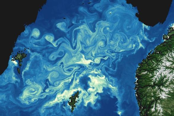
Chlorophyll Eddies
Instruments aboard NASA’s PACE mission are able to distinguish far more about phytoplankton blooms than previous satellites. This image shows chlorophyll concentrations in the Norwegian Sea in July 2025. Chlorophyll acts as a proxy for phytoplankton, which produce the chemical as they process sunlight into food and oxygen.
Despite their microscopic size, phytoplankton have enormous collective effects. Scientists estimate that phytoplankton produce as much as half of the Earth’s oxygen in addition to helping transport carbon dioxide from the atmosphere into the deep ocean. They are also the foundation of the marine food web, feeding nearly all life in the ocean. (Image credit: W. Liang; via NASA Earth Observatory)
#eddies #flowVisualization #fluidDynamics #physics #phytoplankton #satelliteImage #science
Whorls of Sea Ice
Fresh snow shines white on the southern end of Greenland in this satellite image, taken in late February 2025. Whorls of sea ice sit off the coast, where they trace out patterns that reflect the winds and ocean currents of the region. Arctic sea ice typically reaches its largest extent by early March before experiencing a long season of melting. Both the presence and absence of sea ice have a large effect on the Arctic regions. Sea ice helps dampen wave activity; without it, seas are higher and more dynamic, creating more aerosols that seed cloud cover in the Arctic and elsewhere. (Image credit: L. Dauphin; via NASA Earth Observatory)
#climateChange #fluidDynamics #oceanCurrents #physics #satelliteImage #science #seaIce
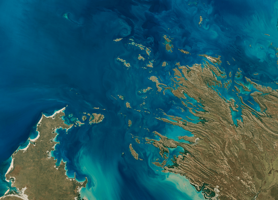
Buccaneer Archipelago
Off western Australian, hundreds of low-lying islands and coral reefs jut into the ocean as part of the Buccaneer Archipelago. Tides here have a range of nearly 12 meters, so water rips through the narrow channels as the tide ebbs and flows. These fast flows lift sediment that dyes the water a bright turquoise. (Image credit: M. Garrison; via NASA Earth Observatory)
#fluidDynamics #oceanTides #physics #satelliteImage #science #tides
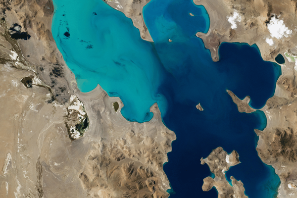
Growing Salty
Ngangla Ringco sits atop the Tibetan Plateau, breaking up the barren landscape with eye-catching teal and blue. This saline lake sits at an altitude of 4,700 meters, fed by rainfall, Himalayan runoff, and melting glaciers and permafrost. The lake, like many inland bodies of salt water, has no outflow. Instead, water evaporates from the lake, leaving behind any salts that were dissolved in it. Over time, those left-behind salts build up and make the lake ever saltier. (Image credit: NASA; via NASA Earth Observatory)
#astronaut #dissolution #evaporation #fluidDynamics #physics #salinity #satelliteImage #science