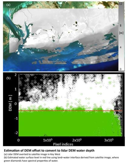
Eyes on Earth Episode 123 – Bathymetry Mapping
--
https://www.usgs.gov/centers/eros/science/eyes-earth-episode-123-bathymetry-mapping <-- shared link to podcast
--
https://www.linkedin.com/posts/gregcocks_gis-spatial-mapping-activity-7214045947876581377-4zcm <-- my earlier overview post
--
#GIS #spatial #mapping #research #remotesensing #earthobservation #landsat #satellite #water #hydrology #marine #hydrospatial #bathymetry #topobathy #elevation #seafloor #Landsat9 #LandsatNext #resolution #PuertoRico #Guam #oceanoptics #atmosphere #coast #coastline #podcast #interview
@USGS @EROS
--
https://www.usgs.gov/centers/eros/science/eyes-earth-episode-123-bathymetry-mapping <-- shared link to podcast
--
https://www.linkedin.com/posts/gregcocks_gis-spatial-mapping-activity-7214045947876581377-4zcm <-- my earlier overview post
--
#GIS #spatial #mapping #research #remotesensing #earthobservation #landsat #satellite #water #hydrology #marine #hydrospatial #bathymetry #topobathy #elevation #seafloor #Landsat9 #LandsatNext #resolution #PuertoRico #Guam #oceanoptics #atmosphere #coast #coastline #podcast #interview
@USGS @EROS