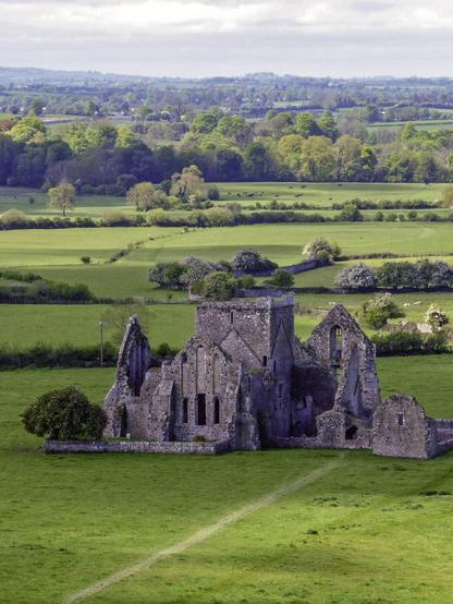
May 2012 | Cashel, Ireland
#ruin #architecture #historicplaces #ireland #rockofcashel #countytipperary
Photograph taken in Thurles around 1940. Why was the road so wide? So that cattle/sheep could be driven to market, maybe? Another reason?
https://www.duchas.ie/en/cbeg/41582
#Ireland #IrishHistory #Tipperary #CountyTipperary #Thurles #HistoricalPhotography
https://archive.org/details/irishsurnamesandslaveownership
Irish Surnames And Slave Ownership
by
Liam Hogan
Publication date
2015-03-06
Topics
#irish, #ireland, #slavery, #history, #caribbean, 'unitedstatesofamerika, #blackchattelslavery, #slaveownership, #slaveships, #BightofBiafra, #Anomabu, #Ghana, #StHelena, #GrandCapeMount, #Liberia, #SierraLeone, #Africa, #Calabar, #Nigeria, #BananaIslands, #ÎlesdeLos, #IvoryCoast, #NewCalabar, #Dublin, #Mayo, #Carlow, #CountyWicklow, #Galway, #CountyDonegal, #CountyMeath, #CountyTyrone, #CountyAntrin, #CountyLouth, #Cork, #Waterford, #CountyDerry, #CountyLaois, #CountyTipperary, #CountySilgo, #Jamaica, #Antigua, #Honduras, #StKitts, #StKittsandNevis, #Grenada, #Dominica, #Waitukubuli, #Nevis, #VirginIslands, #StLucia, #Guyana, #Montserrat, #Bermuda, #TheBahamas, #Tobago, #StVincent, #StVincentandtheGrenadines, #Trinidad, #TrinidadandTobago, #Barbados, #Mauritius, #CapeofGoodHope, #SouthAfrica, #AntiguaandBarbuda, #unitedkingdom, #britishempire, #greatbritain, #colonialism, #imperialism, #Anguilla