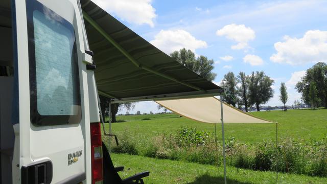
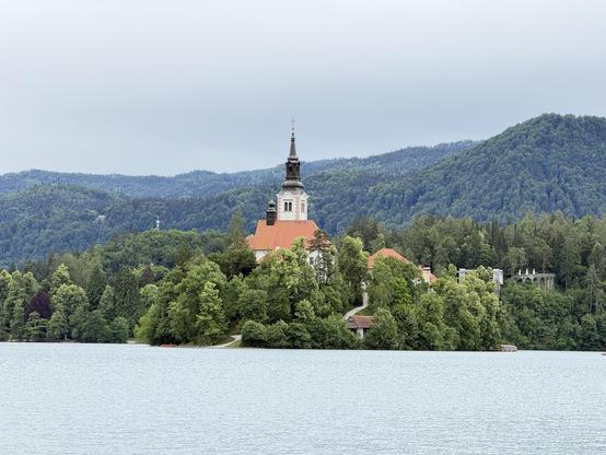
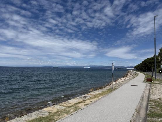
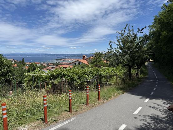
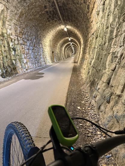
[2/2] Within the Universidade de Coimbra’s former palace complex is the Chapel of São Miguel | St. Michael's Chapel, featuring azulejos (tiles) & a grand organ (📷1), & Sala dos Capelos | the Great Hall of Acts, formerly the throne room, with carpeted walls & painted ceiling (📷2). In the nearby Museu da Ciência | Science Museum, this uncomfortable-looking lecture theatre predates the adjacent Physics Cabinet, an 18th C. collection of teaching instruments, by ~100 years (📷3). The Cabinet of Curiosities is a captivating display room for bizarre objects (📷4). We also visited the Chemistry Lab before descending through the medieval streets of the Alta to view the 12th C. Sé Velha de Coimbra, a Romanesque fortress-like cathedral. Then along the Rua da Sofia in the Sofia area, lined with former colleges & convents that seemed somewhat neglected externally.

🇵🇹 #portugal 🇪🇺 #europe 🚀 #travel 🚐 #camperVan #nomad #roadTrip #vanLife 🌍 #unesco

[1/2] The Universidade de Coimbra | University of Coimbra complex occupies a hilltop overlooking the Rio Mondego (📷1); it’s one of Europe’s oldest universities, founded in 1290 CE. Together with the Alta (upper town) & Sofia (lower town) areas of the city historically associated with the university, it’s a UNESCO World Heritage Site. Paço das Escolas | Palace of Schools, a former 12th C. royal palace & tower, seen from the main university courtyard (📷2). Also adjoining the courtyard is Biblioteca Joanina | the Joanina Library c. 1728 (📷3), which incorporates a lower floor prison (self-regulation separated academics from common criminals until 1834) & middle floor exhibition area. The jewel is the library’s Baroque “Noble” upper floor, featuring gold-leaf/ oak interiors & centuries-old books. Regarded as one of the world’s most beautiful libraries, it actively supports bat colonies for moth control—with certain 🦇💩 precautions. All photography is prohibited during the 10min tour slot in here, so this image is from UdeC (📷4).

🇵🇹 #portugal 🇪🇺 #europe 🚀 #travel 🚐 #camperVan #nomad #roadTrip #vanLife 🌍 #unesco

Conímbriga, south of Coimbra, is the largest and best-preserved Roman archaeological site in Portugal; its mosaics are considered among the best surviving in Europe. Originally a Celtic settlement (“-briga” implies fortification & pre-Roman foundations are visible), it flourished from the 2nd C. BCE due to its strategic position on a key road linking Olisipo (Lisbon) & Bracara Augusta (Braga). It became a prosperous city of some 10,000 people at its peak in the Roman province of Lusitania, before being gradually abandoned during 5th C. CE Germanic (Swabian) invasions. Although ~80% of the site remains underground, excavations reveal the typical features of a Roman town. The ruins comprise houses of the elite, a forum (civic centre), thermae (baths), defensive walls, road infrastructure and an amphitheater remnant. The open-air site offers in-situ insights into provincial Roman urban planning, social stratification (elite villas vs. common housing) & engineering (water systems, heating, fortifications), while the on-site museum exhibits items from daily life, coins, tools, mosaics & sculptures recovered from the (ongoing) excavations.

3rd C. mosaic in the “House of the Skeletons” (📷1). 2nd C. private baths in the “House of Cantaber” (📷2). Water garden & mosaics in the 1st C. “House of Fountains” (📷3); note the minotaur in a maze on the right. Also in the same house, a hunting scene mosaic (📷4).

🇵🇹 #portugal 🇪🇺 #europe 🚀 #travel 🚐 #camperVan #nomad #roadTrip #vanLife 🏛️ #roman

Calonge 04.04.2026. There was a medieval fair, it was very pretty with vegan food and a very nice frenchwoman who sold me lots of natural soaps #campervan #vanlife
Today was a nice day, very sunny, very calm. The food was good, the hair was quite decent and I will sleep in a very pretty place #campervan #vanlife

Northern Portugal

It’s been 19 years since we last visited Portugal—and then only Lisbon, en route to Brazil. On this occasion the camper van would give us much more access to varied landscapes and to traditional Portuguese culture. We began our exploration in the north.

Coordinates

Valença

We first saw Fortaleza de Valença from the Spanish town of Tui, across the Rio Minho | Río Miño, the Spain/ Portugal border (📷1). Fortifications were begun c. 1262 CE but greatly expanded during 17–18th C. conflicts between Spain and Portugal, with bastions, walls and moats defending two enclosed areas: the inner town or “Praça-Forte” (📷2) and the outer defensive belt or “Coroada”. The inner town is rather touristy, filled with shops and eateries (📷3). However, pastel de nata can be obtained (📷4); the consumption of these small custard tarts may be regarded as confirmation of having arrived in Portugal!

Peneda-Gerês National Park

We parked in the village of Covide on the boundary of Parque Nacional da Peneda-Gerês | Peneda-Gerês National Park, part of the UNESCO Gerês-Xures Transboundary Biosphere Reserve. We’d come to hike the PR1–Trilho da Calcedónia. As we ascended (counterclockwise to do the steeper section first/ going up) we looked over the granite terraces built into the opposite side of the valley (📷1). We’d noted these on the scenic drive inland; stone cleared from fields was used in traditional small-scale subsistence farming to create retaining walls for flat plots that resist erosion, enabling utlization of steep slopes for growing crops. On the granite slopes above Covide was a fortified hilltop settlement (“castro”) from the Iron Age. Here’s the view from the “town centre” at Ruínas da Calcedónia | Ruins of Calcedónia (📷3); archaeological remains (walls, terraces, hut traces—to trained eyes) indicate a small but well-defended Celtic-influenced community. After the Roman conquest of Iberia (2nd–1st centuries BCE) this region was integrated into the province of Lusitania; castros were abandoned, reorganized or Romanized. Local info suggests the hillfort was occupied by Romans who called it Calcedónia; they were in the vicinity, but indications of significant or sustained Roman presence seems lacking (they tended to shift settlement into more accessible valleys/ along roads). Flower of the day goes to Narcissus triandrus | Angel’s-tears, endemic to Portugal, Spain and France (📷3). As the loop trail crested the ridge we had views deeper into the park. We passed under and between gigantic boulders then began descending; the pink-flowering bushes are Erica australis | the Spanish heath, which is native to the western Iberian Peninsula and Tangier (📷4). As we returned to the village we passed a Roman granite column mile marker. A 7km/ 3h 15min loop; tiring due to attention needed to footing.

Guimarães

The centre of Guimarães, founded during 10th–12th centuries, is a UNESCO-listed World Heritage Site due to its well-preserved medieval layout and importance in Portuguese history; it’s billed as the “birthplace of Portugal” on account of links to nation building and its first king, Afonso I. Castelo de Guimarães | Guimarães Castle was initially built by Countess Mumadona in the late 10th C. likely from wood and for the purpose of protecting the monastery from attacks; its present form dates to the late 13th C. (📷1). Paço dos Duques de Bragança | Palace of the Dukes of Braganza was built c. 1420–30 CE for Afonso I, Duke of Braganza; as a large, fortress-like noble residence, it required considerable heating—as reflected in the multitude of tall conical chimneys on the roofline (📷2). Largo da Oliveira is a public square in the heart of the old town, surrounded by historic architecture and religious landmarks (📷3). In the narrow yet impeccably maintained and clean medieval streets (📷4) we found a delicious selection of cakes to bring back to the van.

Douro Valley

The Alto Douro Wine Region is a UNESCO-listed cultural landscape that has produced wine for some 2,000 years; the region’s best known product is Port, a sweet, full-bodied fortified wine. We intersected the Rio Douro | Douro River at Mesão Frio, where we parked at a cemetery for lunch with this awesome view from the van door (📷1). Our drive continued up the Douro Valley between the towns of Peso da Régua and Pinhão, which local intel had informed us was the most scenic section (📷2&3). We came back to the river at Parque Arqueológico do Vale do Côa | Côa Valley Archaeological Park, near the town of Vila Nova de Foz Côa—still in the upper part of the wine region (📷4).

Parque Arqueológico do Vale do Côa | Côa Valley Archaeological Park, a UNESCO World Heritage Site, is home to the world’s largest concentration of open-air Palaeolithic art (1,400+ engraved rocks, although the majority are now submerged). We began in Museu do Côa | Côa Museum, which catalogues art as old as 30,000 years and displays some replicas, such as “Quinta da Barca 3” (📷1). This ibex is depicted with two head positions/ overlapping horns, indicative of artistic experimentation with frame animation to simulate movement 20–15,000 years ago! The museum’s motif (📷2) is a filiform etching (i.e. composed of thin grooves), possibly an ibex or deer, made ~12–11,000 years ago. Older examples mostly depict large animals, but people are also seen in more recent works. The in situ petroglyphs on schist canvases along the banks of the Côa River are concentrated in four main areas, to which access is permitted only via pre-booked guided tours. The site you’ll see depends on the time of day (shadows change etching visibility) and language of the tour: we were allocated to “Canada do Inferno”, accessed by 4×4 and foot. The first of ~40 engraved rocks known here was discovered (more accurately, recognised) as recently as 1991 (📷3). Rocha 1 works are 30–22,000 years old and clearly depict aurochs and a two-headed horse. Rocha 14 features the museum motif, almost invisible; it was easier to make out the front of this horse, etched using a pecking technique (📷4). We viewed two other rocks, 2 and 15, during the 2.5h tour.

Why did they do it?

Museu do Côa notes four main theories on the motivations of prehistoric artists:

Art for art’s sake: Our human ancestors created the works as a pastime and for pure aesthetic pleasure.

Sympathetic magic and fertility rites: The works, depicting prominent animal bellies and hunting weapons or wounds, and with an emphasis on human sexual characteristics, were linked to magic practices intended to ensure hunting success and human fertility.

Shamanism: Some hybrid figures have been interpreted as medicine men/ shamans and incomplete figures are seen as “emerging” from the rock; it has been proposed such works may be linked to shamanic rituals.

Woman of Piscos c. 20–25,000 years old

Structuralism and post-structuralism: The works are an organized set of signs whereby their associations, placement and location impart meaning beyond the depictions themselves i.e. a language-like system of symbols, that had social importance.

🤔 Curiosity

The Portuguese lady who guided us at Canada do Inferno for our Côa Valley Archaeological Park tour was, it turned out, also a forager/ edible plant buff. She pointed out a variety of seasonings and salad ingredients, so there were things to look at (and sniff) on the trail before we even got to the rock art. We also spotted some pretty non-edibles. Prunus amygdalus | the almond (📷1); before the young nuts harden they taste sour, so are dipped in salt in the Middle East to make them more palatable. Wild Lavandula pedunculata | Spanish (or French) lavender is native to Iberia, Morocco and western Türkiye (📷2). Umbilicus rupestris | the wall pennywort is edible in small quantities—more of a wild garnish than a main vegetable (📷3). Ophrys tenthredinifera | the sawfly orchid is native to the Mediterranean region (📷4); we also re-identified Himantoglossum robertianum | the giant orchid here.

Paiva Walkways

Passadiços do Paiva | Paiva Walkways is a paid (2€ pp) 8.75km point-to-point trail following the river gorge between Areinho and Espiunca, within the Arouca UNESCO Geopark. We parked the night before at the Areinho end and walked towards Vau (onward to Espiunca is closed). Much of the route is boardwalk and utilizes many stairs (📷1). Another attraction in the geopark is a 516m pedestrian suspension bridge, which can be traversed from the walkway for an additional fee (📷2). The route provides views of the rio Paiva from above and waterside (📷3). The beach at Vau is made of fine gravel and ideal for a lunch break (📷4). You won’t see the giant trilobite fossils or “birthing stones” (granite from which biotite nodules are ejected) that the park is known for from the Passadiços, but the gorge landscape is especially accessible here. 10km/ 3.5h return.

We identified a number of Passadiços do Paiva | Paiva Walkways trailside smalls. This is Linaria triornithophora | the three birds toadflax, which is endemic to Portugal (📷1). Scilla monophyllos | the single-leaved squill is native to Portugal, western Spain and Morocco (📷2). There were a number of native Quercus suber | cork oaks beside the trail, some close enough to tempt those with knives to prove cork was indeed inside (📷3). Hyacinthoides hispanica | the Spanish bluebell is native to the Iberian Peninsula (📷4). We also re-identified Pararge aegeria | the speckled wood butterfly, attracted to the moist riverside environment.

Porto

Porto was the Roman settlement of Portus Cale, giving rise to the country name of Portugal, although Roman remains are fragmented. Today central Porto is a World Heritage Site, with visible evidence of its evolution from a medieval to baroque town and of its role in Atlantic trade. Our train arrived into São Bento, with lobby tiles depicting Portuguese history, and we began exploring in the upper city. There were queues to climb Clérigos Tower for panoramic views (📷1) and at the nearby Livraria Lello bookstore (📷2). On to Mercado do Bolhão, similarly suffering from excess humanity on Good Friday. Given a recommendation from the ladies in a specialty coffee shop, lunch was at Café Santiago on Rua de Passos Manuel: a francesinha, the iconic Porto sandwich, with fries and port wine (📷3). We walked downhill on the pedestrianised 16th C. Rua das Flores, into the Centro Histórico (📷4).

Porto’s medieval core is around Sé do Porto | Porto Cathedral (📷1), the tower of which can also be climbed for city views. From the cathedral we continued downhill through sometimes narrow and steep streets (📷2), arriving at the Douro riverfront in Ribeira district. Lined with colourful houses the area was busy with throngs of Easter visitors (📷3). In a multilingual procession we traversed the two-tiered Ponte de Dom Luís I | Dom Luís I Bridge (📷4), connecting Porto to caves do Vino do Porto—the port wine cellars of Vila Nova de Gaia.

We continued south into Portugal’s central region.

#2026 #camperVan #europe #hiking #nationalPark #nature #nomad #portugal #roadTrip #romans #travel #unesco #vanLife

Northwestern Spain

Leaving the Basque Country we continued westward into the Spanish provinces of Cantabria looking for ancient art, Asturias hoping for mountain vistas and Galicia in search of scenic coastline.

Coordinates

Cantabria

Another day, another art gallery—although this one exhibits works tens of thousands of years older than Bilbao’s Guggenheim. The Museo de Altamira (near Santillana del Mar) houses faithful reproductions of some of the most famous prehistoric rock paintings known, inside a bespoke “Neocave”. Recognised for what they were in 1879, the original cave was inhabited by Paleolithic hunter-gatherers from 35,000 years ago until a rockfall 13,000 years ago sealed it, putting it out of use as a seasonal camp—but preserving the contained artefacts and artworks. Several naturalistic bison are depicted on the rock ceiling, formed from a drawing and engraved detailing coloured black with charcoal, then infilled with red ochre (📷1); this one was realised ~15,000 years ago. In some cases—as here—the designs utilise the ceiling’s natural contours to give the animals a sense of depth and movement, making it one of the earliest known examples of shading and volume in art. A number of handprints adorn the ceiling; the artist’s hand was coated in red ochre then pressed onto the rock, in this case 22,000 years ago (📷2). An alternative “airbrush” technique was also utilised to create an outline hand design. The oldest work comprises several parallel double-curved lines; this seemingly abstract “Sign” was painted 36,000 years ago (📷3). Whether the paintings had special meaning, or were simply “art for art’s sake”, is not known. An adjacent exhibition hall contains recovered artefacts and tells the story of human evolution. Among the artefacts found near the cave entrance were these pendants, carved from the hyoid bones of a horse 22,400 years ago (📷4). The entrance to the actual cave is only 300m from the museum, but you can’t approach it. With 17 other caves Altamira forms the “Cave of Altamira and Paleolithic Cave Art of Northern Spain” UNESCO World Heritage Site.

Asturias

Sunset on our mountain pitch

We found a pitch adjacent to Mirador “Pedro Udaondo” in Asiegu with a view of the mountains in Picos de Europa | Peaks of Europe (📷1); the tall and sheer block of rock on the horizon is Picu Urriellu (the local Asturian name) | Naranjo de Bulnes (the Castilian name) at 2,519m. The range extends for 20km, forming part of the Cantabrian Mountains in northern Spain. In the vicinity we encountered Asturian sheep, an endangered Celtic breed with a long, coarse shaggy cream fleece and brown head/ legs that is indigenous to the area (📷2). Circling high overhead as we admired the landscapes were Neophron percopterus | Egyptian vultures, with their distinctive contrasting underwing pattern and wedge-shaped tails (📷3); they must have very recently flown in from Africa (and will return there around September time). In the evening we went down the hill into the mountain village of Asiegu (📷4) where we enjoyed an excellent dinner of local dishes at Sideria Casa Niembro (who had provided the gate code for the free pitch).

Touring isn’t only about the scenery: sampling traditional foods is an obligation. From Sare in the northern Basque Country we savoured Gâteau Basque | Pastel Vasco | Etxeko Biskotxa, a traditional pie-like cake made of a buttery, shortcrust pastry typically filled with cherry jam (📷1) or vanilla cream. In southern Basque Country we sampled Tarta de Queso | Gazta Tarta, the crustless, creamy and caramelized or “burnt” cheesecake originating from San Sebastian but now widely available (📷2); we acquired ours in Zumaia. In the Asturian mountain village of Asiegu we shared a meal of delicious chorizo sausages, corn fritters served with strong Cabrales blue cheese and apple jelly (📷3), and tender roast kid. Our host poured small amounts (a culín) of the almost flat local sidra | cider from a height over a special bucket (📷4); doing so releases tiny bubbles, the temporary fizz imparting texture and flavour that—for our part in the performance—should be consumed within seconds before it reverts!

With a fresh overnight dusting of snow on the peaks we set out to hike an out-and-back section of the 12km point-to-point Ruta del Cares (PR-PNPE 3) trail in Parque Nacional de los Picos de Europa. This is the park’s most popular hike, linking Poncebos (Asturias) and Caín (León); it’s considered one of Spain’s most beautiful trails. We parked at Poncebos and initial views of the clear-flowing Río Cares from near the trailhead looked promising (📷1); a short stretch of road led to a well-formed path. The trail climbs through a deep limestone gorge with sheer cliffs that tower above the river; erosion has created rock pillars (📷2) and natural arches (📷3)—but human engineering in this landscape also must be admired. Between 1915 a the early 1920s, the company Electra de Viesgo built a canal to carry water from the Río Cares at Caín to a hydroelectric plant at Camarmeña–Poncebos. Up to 11 km long, it runs through ~70 tunnels excavated largely by hand with the aid of explosives; 11 workers were killed during construction. The maintenance path for this canal, widened between 1945–50, became today’s Ruta del Cares: the canal still carries water alongside, above and beneath the trail (📷4).

At one point on Ruta del Cares, looking down into the canyon, we observed what we think must be a resurgence, where water that has been flowing underground reappears at the surface; they’re common in karst landscapes (📷1). The trail, like the canal itself, passes through a number of tunnels when cutting into the sheer rock face isn’t enough (📷2); this bridged section includes a steel grate so you can see the drop beneath your feet (📷3). We turned around just beyond this window in the rock wall (📷4), at ~8.5km (about two thirds along the route), corresponding to the Riega las Párvulas waterfall, just beyond the border with the León region.

The trail was no less dramatic walking it in the opposite direction (📷1). On our outbound leg the mountain goats were generally high above us, sometimes heard but not seen. On our return leg a number had descended onto the trail (📷2). At one point we encountered a “toll goat”, hoping to extract a fair exchange for passage through one of the tunnels (we didn’t feed it). A view ahead to a stretch of “up” before the final descent to the trailhead (📷3). Did we mention we saw goats? This she-goat was actively licking at a very particular patch of rock, which we took to be a quest for salt (📷4); apparently sodium is scarce in their normal alpine plant-based diet. All told the hike was 17km/ 5h out-and-back. Note there’s a non-zero probability of rockfall, but this trail is up there with the best we’ve done.

Smalls from the Ruta del Cares were plentiful. Glandora prostrata | the creeping gromwell is native to Spain, Portugal and France (📷1); this was everywhere trail side, with a velvety sheen that seemed to confuse autofocus! Erodium cicutarium | the redstem stork’s bill is native to the Mediterranean Basin (📷2); after flowering it produces long, beak-shaped seed pods. Helleborus foetidus | the stinking hellebore is a mountain native belonging to the buttercup family (📷3); the species name is Latin for “foul-smelling”, the result of bruised/ crushed leaves. Globularia nudicaulis | the leafless-stemmed globularia (📷4); this native is so-named because the stem is naked, with leaves in a low rosette at ground level.

Helicella itala | the heath snail is a native land snail (📷1); during hot, dry periods it climbs up vegetation and seals itself inside its shell to avoid overheating and dehydration. Dianthus hyssopifolius | the fringed pink is native to Spain, Portugal and France (📷2); it’s well adapted to rocky alpine environments. Pinguicula grandiflora | the large-flowered butterwort is another native (📷3); the flower is atypically large for a butterwort. Not all the smalls we noticed were living: being limestone country, some of the rocks contained the bodies of marine animals fossilised millions of years ago (📷4). Tectonic uplift transformed an ancient shallow sea into mountains!

The next morning it was hard to beat sipping coffee with a view out the van sliding door from pitch in Asiegu, as the rising sun lit the snow-capped mountains of Picos de Europa:

Morning light on Picos de Europa

Ruta a los Lagos de Covadonga (PR.PNPE-2) was our second trail in Parque Nacional de los Picos de Europa. The road from Covadonga to reach the trailhead is fairly long and winding; it closes to private cars at busy times (replaced by park and ride). En route we stopped at Mirador de la Reina for stunning views back over the still misty lowlands we’d driven through (📷1). There in the morning chill we were in turn observed by roosting Gyps fulvus | Eurasian griffon vultures, perhaps waiting for thermals to form (📷2). We drove on to Lago Enol, the first of a pair of glacial lakes (📷3), parking at Aparcamiento Buferrera. We noticed fire on an adjacent peak and later watched a helicopter drop a bucket of water on it. There’s a short detour to Minas de Buferrera, where manganese and iron were extracted intermittently between 1868 and 1979 (the road to the lakes is a legacy of mining activity). “Flower of the day” went to Narcissus bulbocodium | the hoop-petticoat daffodil, a native to Spain, Portugal and France (📷4).

Continuing on Ruta a los Lagos de Covadonga, Largo de la Ercina had the prettier backdrop (📷1). We noted more new-to-us flowers; this is Erythronium dens-canis | dogtooth violet, native to central and southern Europe (📷2). A large part of the trail led us over limestone areas (📷3). Ermita de El Buen Pastor is a small hermitage sitting in the Vega de Enol, a high mountain meadow adjacent to Lago Enol at ~1,070m altitude (📷4); the contrast of this small human-built structure set against a vast, dramatic alpine landscape gives you pause. This was a 6km/ 2h loop.

For our last night in Asturias we came to Salas (📷1); this historic village offers accommodation to pilgrims walking the Camino de Santiago. What drew us here in a van, you might ask? Four reasons:

  • First, it has a highly-rated laundromat. After a little over a week on the road our attire was in need of refreshing.
  • Second, it was a comfortable distance between points-of-interest. Driving can be tiring, especially when narrow mountain roads are involved.
  • Third, it’s camper van/ motorhome friendly, providing free-to-use services: parking overnight legally in dedicated area; potable water; grey water disposal; and toilet cassette emptying.
  • Lastly, we also needed to buy groceries. In addition to usual supplies we acquired the local specialty biscuit, Carajitos (📷2). Available from La Casa del Profesor (est. 1918) on the main street, these soft and flavoursome hazelnut-based treats are apparently world famous in Asturias!
  • SalasCarajitos

    Galicia

    We continued west to Monumento Natural Praia das Catedrais (near Ribadeo), where a series of arches resemble the flying buttresses of Gothic cathedrals; at low tide sea conditions didn’t allow us safe access. Views from the cliff top platforms were underwhelming.

    Disappointed, we drove on to the UNESCO World Heritage Site of Muralla Romana de Lugo | the Roman walls of Lugo—once the Roman colonial town of Lucus Augusti in the province of Hispania Tarraconensis. The walls were built in the 3rd C. CE to defend against local tribesmen and Germanic invaders. About 2.1km long, 4.2m wide and 8–12m in height, internal and external stone facings were supported by a cemented rubble core (📷1); you can walk the full length of the parapet. Originally featuring an incredible count of 88 towers, these were mostly semicircular at intervals of 5.4–12.8m with bases of dressed granite topped with slate (📷2); 49 are still intact. Five of the current 10 gates are Roman in origin, including Porta de San Pedro (📷3); it was reconstructed in 1781. Many buildings within the walls are badly decayed; Lugo was nearly deserted during our visit. We looked through Sala Porta Miñá, a contemporary history museum, where they have an excavated stone-built Roman cloaca | sewer on display (📷4).

    The 55m Torre de Hércules | Tower of Hercules (📷1&2) at A Coruña was built during the 1st C. CE, during the reign of Emperor Trajan, and is UNESCO-listed as the oldest surviving Roman lighthouse. It’s still in use today, making it the oldest functioning lighthouse in the world: that’s two thousand years of continuous maritime safety service! It underwent major restoration in the 18th C. (reflected in the current neoclassical shell) and until the 20th C. was known as Farum Brigantium. You can ordinarily climb the spiral staircase within the Roman core; it was closed for renovation during our visit. On the adjacent granite headland are even older relics: the Petroglifos de Punta Herminia are a group of prehistoric rock carvings dated to 2500–1800 BCE. They’re very weathered/ hard to make out, so not as photogenic as the Atlantic surf smashing onto the rocks below (📷3). Onwards to O Ézaro, where we admired the dramatic rocky landscape surrounding the Río Xallas (📷4). This reflects a very old granite core formed ~300 million years ago, and very lengthy erosion causing large fractures, rounded domes, sheer cliffs and boulder formations.

    Fervenza do Ézaro is a waterfall on the Río Xallas | River Xallas at O Ézaro on the rugged Costa da Morte | Coast of Death (where Atlantic storms, hidden rocks and fog/ sea mist have led to many shipwrecks and drownings). Next to a hydroelectric power plant, the Ézaro waterfall is billed as “one of the only sites in Europe where a river cascades directly into the sea” (📷1). While this could be contested given they are ~1.4km upstream of the shoreline, the falls are nevertheless scenic (📷2). About 16km south of O Ézaro is the village of Carnota, site of the Hórreo de Carnota, built 1760–1783 (📷3). This hórreo | granary in the typical Fisterran style is the longest in Galicia at 34.76m. Once used to store, dry and conserve corn/ other crops, most hórreo (there are 884+ in this municipality alone) are now merely “decorative statements” given the decline of agricultural traditions. Carnota also boasts a long sandy beach, Praia de Carnota, backed by sand dunes and a salt marsh. From it you can see to Cape Finisterre (after the Latin “Finis Terrae” | “end of the earth”), which the Romans considered the edge of the known world (📷4).

    Christian pilgrims flock to Santiago de Compostela’s cathedral (📷1), built 1075–1211 CE with later additions, to visit the tomb of the apostle Saint James the Great. Although said to have died in Jerusalem in 44 CE, medieval legend holds that his followers, guided by divine intervention, brought his body to Galicia. Pilgrims walk the Camino de Santiago, a network of interlinked routes converging here from across much of Europe—as symbolised by the scallop shell. A unique feature of the cathedral’s nave, the “Botafumeiro” is a large silver censer (incense burner) that is swung across the transept during special services (📷2). The cathedral fronts onto to Praza do Obradoiro, a grand square surrounded by other historic buildings including Pazo de Raxoi | the neoclassical town hall (📷3) and Hostal dos Reis Católicos, a luxury hotel that was once a 15th C. pilgrims hospital (📷4). The medieval historic center of town is a UNESCO-listed World Heritage Site.

    Mercado de Abastos is Santiago de Compostela’s main market, offering fresh seafood (📷1), produce, and tapas—if you’re not too early! The old town includes examples of a classic feature of northern Spanish architecture called a “galería” (📷2); these enclosed balconies are especially common in Galicia and provide a “glass skin” that shields the home from rain and wind while providing passive solar heating and extra usable space (plants, laundry drying, etc.). Parque da Alameda is a green space close to the old town and offers an elevated perspective of the cathedral skyline (📷3). We visited Museo do Pobo Galego, a former convent that exhibits artefacts from traditional Galician life; it features an unusual staircase with three intertwined spiralling paths that end abruptly at different doors (📷4). The baroque Monastery of San Martín Pinario near the cathedral is said to have ornate interiors; it was closed to visitors.

    From Santiago de Compostela we drove south. Ría de Vigo is a drowned river valley near the city of Vigo; it’s known for providing a sheltered harbour (the Cíes Islands act as a barrier against the Atlantic), for mussel farming rafts called “bateas” and for white sand beaches. On the northern side Praia da Folla de Nerga a.k.a. Playa de Nerga is popular (📷1). On the southern side there’s a string of beaches on the outskirts of Vigo connected by a long promenade with views of the Cíes Islands (📷2). At the town of Baiona the large Fortaleza De Monterreal is surrounded by ~3km of walls, mostly built between the 11th to 17th centuries (📷3); the strategic hilltop has been fortified for 2,000 years and is now occupied by a hotel. We turned inland to Tui, wandering the medieval old town that features a fortress-like cathedral built during the 12th and 13th centuries (📷4).

    Tui offers views across the Miño River into the Portuguese town of Valença—the next destination on our loop through the Iberian Peninsula.

    #2026 #asturias #camperVan #cantabria #europe #galicia #hiking #nationalPark #nature #nomad #roadTrip #romans #spain #travel #unesco #vanLife

    France into Basque Country

    Despite concerns about rising fuel costs thanks to Trump’s war on Iran, we decided to press on with plans to tour the Iberian Peninsula—while still feasible. This involved a relatively quick transit of France to reach the Basque Country where our tour would properly commence.

    Coordinates

    A transit of France

    Rain, sleet and hail chased us out of Frankfurt, through the Saarland and over the border into the historical province of Lorraine (with Alsace, Champagne and a few smaller bits, the region of Grand Est since 2016). Our Day 1 pitch was by a marina and faux beach on Lac du Der-Chantecoa, France’s largest artificial reservoir, created to prevent flooding in Paris (📷1). On Day 2 we drove west then south through Centre-Val de Loire to Saint-Amand-Magnazeix in the region of Nouvelle-Aquitaine, where we shared our pitch with Lacerta bilineata | the Western green lizard (📷2). On Day 3 we made a slingshot around Bordeaux out to Dune du Pilat at La Teste-de-Buch on the Atlantic coast, near the entrance to Arcachon Bay. Said to be Europe’s tallest sand dune, it’s 102m tall and just shy of 3km long (📷3). On to pitch near Garet, where 7,50 € paid into a mailbox nailed to a tree secured a spot in a farmer’s field, in which we set up our shower tent—given an unexpected 25°C (📷4).

    More views of the dunescape at Dune du Pilat follow. The sand forming this dune accumulated here over some 4,000 years. Picked up by wind and blown against inland obstacles, deposits carried by ocean currents along the Aquitaine coast are derived from rock originating in the Massif Central and Pyrenees that has been progressively reduced by wind, rain, frost and river journeys over the course of many thousands of years. Just so you can pant while climbing it, and yelp excitedly (even if only on the inside) as you descend it—much more rapidly, of course.

    From the macro to the micro: jewels in the sand at Dune du Pilat. The dune is home to a variety of dull and not-so-dull bugs, some of which we identified. Pyrrhidium sanguineum | the Welsh oak longhorn beetle sounds as if it’s far from home, but is actually common in much of Europe, where it prefers a supply of oak (📷1). Native Hylobius abietis | the large pine weevil is considered a pest on pine plantations, as they damage seedlings (📷2). The unsightly destruction of forest adjacent to the dune is however the result of fires in 2022 (and subsequent felling), triggered by human activity. Native Coccinella septempunctata | the seven-spotted ladybird is readily identified by counting the three spots on each red elytron, with the seventh spanning both (📷3). Native Cicindela campestris | the green tiger beetle is widespread across Eurasia (📷4).

    Northern Basque Country

    Given good weather on Day 4 we detoured a short way inland within the Pyrénées-Atlantiques | Atlantic Pyrenees for some mountain landscapes and insights into northern Basque heritage. The Basque Country is a cultural region spanning the western Pyrenees along the Bay of Biscay, of which about 15–20% lies within France (the three historic provinces of Labourd, Lower Navarre and Soule). We pitched in the village of Sare—or Sara in Euskara, the Basque language (📷1). From there on foot we followed a 9km/ 3.5h “Tour de Sare” loop into the surrounding hills, noting some of the houses were fenced with upright stone slabs—a feature of Basque rural architecture (📷2). There was nothing left of the redoubt at the summit of Suhamendi, although we had views out to the Atlantic and across to peak of La Rhune at 860m elevation (📷3). We encountered Pottoks frequently; biologically Equus ferus caballus | the domestic horse, this is a genetically-distinct, pony-sized local breed adapted for mountain living and is considered one of Europe’s oldest surviving horse types (📷4).

    On the morning of Day 5 (after obtaining Gâteau Basque | etxeko bixkotxa, a traditional pastry) we crossed the pass to Bera in Spain. Having avoided expensive French tolls, it was 1,350km from Frankfurt to the Spanish border.

    Southern Basque Country

    Basque Country

    The Basque Country is a culturally distinct region with its own language (Euskara) and a long history of seeking autonomy from central governments. As noted above, 15–20% lies in France, while about 80–85% lies in Spain. The Spanish bit—southern Basque Country—includes the Basque Autonomous Community (Álava, Biscay, Gipuzkoa) and Navarre, which has a separate status. Tensions here grew during the 20th century, especially under Francisco Franco, whose dictatorship suppressed Basque identity and political expression. This repression contributed to the rise of the separatist group ETA, which used violence from the late 1950s aiming for independence, until it declared a ceasefire in 2011. While the region today has significant autonomy within Spain, debates over independence and historical grievances still shape its political landscape.

    🧭 Exploring

    Our first stop in southern Basque Country was to be Donostia | San Sebastián, but after a stressful tour of the city looking for open-air parking (we’re 3m tall) we gave up and left—without Basque cheesecake from La Viña. Westward to Zumaia, specifically Flysch de Zumaia, for a cliff formation of near vertical strata within the UNESCO Geoparkea Zumaia. These strata formed from sediment/ shells that spent 50 million years under the sea between Iberia and the European continent—until their collision uplifted the flysch layers (marl, limestone and sandstone). At the eastern end of the beach is the Paleocene–Eocene Boundary, where 56 million years ago a large release of greenhouse gases caused a 5–10°C temperature increase; the adjacent strata march down into the sea (📷1). Moving back in time, towards the middle of the beach are the Selandian–Thanetian Stratotype at 59.2 million years ago, when Earth’s magnetic poles flipped polarity, and the Danian–Selandian Stratotype at 61.6 million years ago, when sea level dropped ~80m; you can walk right up to these strata below San Telmo chapel (📷2). Ascend to the chapel and walk along the cliff (📷3); at the end of the rocky headland is the Cretaceous–Paleogene (K–Pg) Boundary, marked by a thin dark layer (📷4). This layer is rich in iridium, corresponding to the Chicxulub asteroid impact in the Yucatan 66 million years ago that wiped out ~75% of Earth’s biota—most famously the non-avian dinosaurs. The return route notes that every one of your steps equates to the passage of about 500,000 years in geologic time. That’s a small step for a human; a giant step for humankind (less than one step = modern humans; five steps = the span of our existence in the Homo genus).

    Gaztelugatxe (near Bakio) is a rocky islet on the Atlantic coast of the southern Basque Country (📷1). We arrived early to the small top parking area, which rapidly filled; motorhomes aren’t allowed in the main area. Beware that entry tickets may be required at busy times (book online). The location is best known for its winding stone bridge (📷2) and staircase connecting the mainland to a hermitage perched on the rock. The medieval chapel, San Juan de Gaztelugatxe, dates back (in various forms) to at least the 10th C. and is dedicated to John the Baptist (📷3). Some visitors feel obliged to ring the chapel’s bell three times and make a wish. Some come to climb the 241 steps leading up to the chapel from the bridge, which served as the location of Dragonstone in the TV series Game of Thrones—although the chapel was of course digitally replaced with a faux castle (📷4). It’s a fairly steep 3km return to the top car park.

    We visited Museo Guggenheim Bilbao | Guggenheim Bilbao Museum—which is a modern art gallery (it displays art), but is considered a museum because it also collects, preserves, studies, and contextualizes art as part of a broader cultural mission. We parked in Berango and took the train into Bilbao. As we approached the museum we encountered “Puppy”; this oversized dog-shaped artwork is covered in seasonal flowers (📷1). Continuing around the building to the riverside aspect lets you better appreciate its non-conformist architectural design by Frank Gehry (📷2). Riverside is also the location of “Maman”, a giant spider that looks as if it could have been a Wētā Workshop installation (📷3). The largest installation inside is called “The Matter of Time” and comprises eight massive, curved steel sculptures that create winding paths you can walk through (📷4). For some folk it “awakens a heightened awareness of one’s own body, of gravity, and of the surrounding space”, apparently. Once inside others will find only what they took in with them…

    From Bilbao we would continue into northwestern Spain.

    #2026 #basqueCountry #camperVan #europe #france #hiking #nature #nomad #roadTrip #spain #travel #unesco #vanLife

    Before leaving Ovar we obtained a “Pão de Ló” sponge cake, the local specialty, for later sampling (📷1); the lady who sold it proudly told us it was her 2x great grandfather’s recipe.

    The reserva natural das Dunas de São Jacinto | São Jacinto Dunes Nature Reserve is bounded on one side by the Atlanic Ocean & on the other by the tidal mouth of ria de Aveiro. It protects an area of dunes but mostly comprises pine forest, offering a habitat for mosquitoes, brambles & gorse. From the hide at Pateira Pequena (a small pond) we heard frogs, but didn’t linger under threat of 🦟 exsanguination. What did impress was the sheer volume of Trichilogaster acaciaelongifoliae | the longleaf wattle gall wasp, which parasitises the invasive Acacia longifolia | longleaf wattle native to SE Australia (📷2). We also met Chalcophora mariana | the pine-borer beetle, native across much of Europe (📷3). The dunes of Praia de São Jacinto can be overlooked from a platform at the end of a boardwalk (📷4). From the hide at Pateira Grande (a large pond) we saw a solitary duck.

    Next stop was to be Aveiro, billed as the “Venice of Portugal”; the canals didn’t impress sufficiently as we drove by hunting for 🅿️, so we kept going. Being Easter, Núcleo Museológico do Sal on the coast wouldn’t be open for our visit, so we turned inland.

    🇵🇹 #portugal 🇪🇺 #europe 🚀 #travel 🚐 #camperVan #nomad #roadTrip #vanLife 🥾 #hiking #nature

    [2/2] More of Ovar’s azulejos, within the context of house façades. Also noteworthy during a tile-spotting wander about the historic centre, there are 7 chapels representing Christ's Scenes of Passion, regarded as the “most representative artistic motif of Ovar.”

    🇵🇹 #portugal 🇪🇺 #europe 🚀 #travel 🚐 #camperVan #nomad #roadTrip #vanLife