"Welp looks like it's time to put the shovel and sand back in the car trunk."
#MNastodon #WinterStormWarning #Minnesota
#US #USA #WinterStorm #community #resilience
#ParkrosePermaculture #WinterStormWarning
Check on your neighbours!

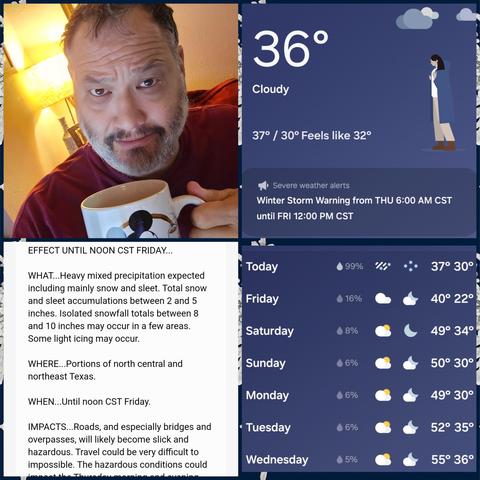
Hope people in the deep south like snow.
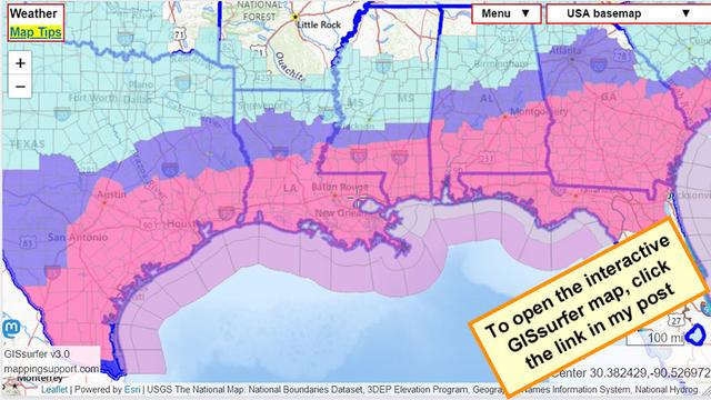
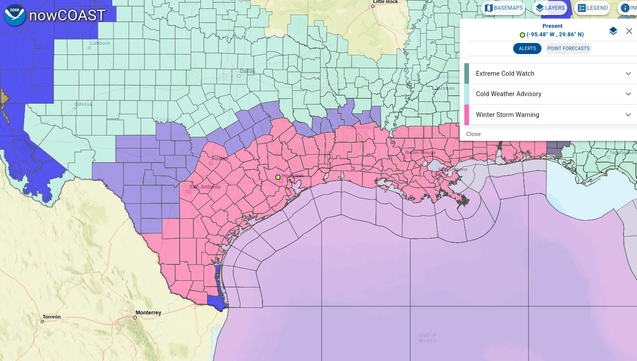
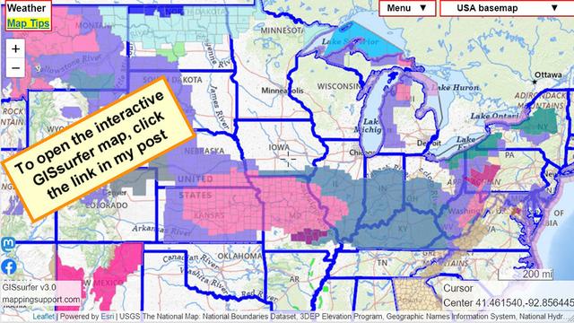
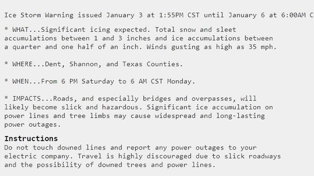
Red area has a #WinterStormWarning
#ArcticBlast
For snowfall forecasts and more info, open the map, click colored area, follow the link. Since the spot you clicked might have more than one type of weather watch or warning, scroll down in the popup since each type of watch or warning has its own link for the details.
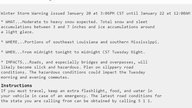
Screenshot text is for the area that includes New Orleans.
To search on an address click Menu > Search.
Open #GISsurfer map:
https://mappingsupport.com/p2/gissurfer.php?center=29.830921,-89.735956&zoom=6&basemap=USA_basemap&overlay=State_boundary,Weather_watch_warning&data=https://mappingsupport.com/p2/special_maps/disaster/USA_weather.txt
#wdefWeather #News12Weather -- #WinterStormWarning now in effect until 7 AM EST Saturday, including #HamiltonCountyTN / #ChattanoogaTN.
Heavy snow & mixed precipitation expected. Total snow accumulations between 2-5" and ice accumulations up to
0.10".
https://forecast.weather.gov/wwamap/wwatxtget.php?cwa=MRX&wwa=winter%20storm%20warning
Coffee brewed, and stocked up with food due to the storm. School was canceled and I imagine many businesses will be closed/close early. Everything will melt by tomorrow afternoon, but let's buckle down.
#ThursdaySelfie #FridayEve #ThursdayVibes #Coffee #Caffeine #WinterStormWarning
NOAA has posted an #IceStormWarning. It is the dark purple area on the map. At the time of my post this is only in SE Missouri. See the screenshot text below.
Note that other areas are also forecast to have freezing rain but not as much as in the ice storm warning area.
To read details from NOAA, open the map, click colored area, follow the link. Scroll down in the popup since each type of watch or warning has its own link for the details.
#WinterStormWarning #KSwx #MOwx #ILwx #INwx #OHwx #KYwx
Open #GISsurfer map:
https://mappingsupport.com/p2/gissurfer.php?center=41.461540,-92.856445&zoom=5&basemap=USA_basemap&overlay=State_boundary,Weather_watch_warning&data=https://mappingsupport.com/p2/special_maps/disaster/USA_weather.txt
As a spring snowstorm slams into the Colorado Front Range, Loveland Pass and Vail Pass are closed for safety reasons. There is no known estimated time for re-opening them.
Read more 👉 https://thenextsummit.org/vail-pass-and-loveland-pass-closed-amid-spring-snowstorm-in-colorado/
#LovelandPass #VailPass #News #Colorado #I70 #US6 #WinterStormWarning
DENVER, COLORADO - In a swift response to escalating winter storm conditions, Colorado Department of Transportation (CDOT) has announced the closure of two critical mountain passes. Both Loveland Pass and Vail Pass have been shut down due to safety concerns amidst a severe winter storm that is expected to blanket Colorado’s northeast mountain regions with heavy snowfall.As of Monday, Loveland Pass is closed between Montezuma Road and I-70, covering Mile Points 220 to 229. This precautionary measure affects a stretch of road just east of Keystone. CDOT has advised that hazardous material vehicles stage at Eisenhower Tunnel and will be