NWS Cheyenne Region:
There's a Red Flag Warning for part of southeastern Wyoming & all of the Nebraska Panhandle today (March 9th). There's also a High Wind Warning for parts of southeastern Wyoming.

Red Flag Warning:
Until 6 pm this evening. Winds gusting between 35 & 55 mph. Relative humidity as low as 13%. Conditions will be favorable for rapid fire growth. Avoid outdoor burning or any activity that may produce a spark and start a wildfire.

High Wind Warning:
Until 6 pm this evening. Westerly winds of 30 to 60 mph with gusts up to 85 mph possible. Impacts mainly to transportation. Strong cross winds will be hazardous to light weight or high profile vehicles, including campers and tractor trailers.

#WYwx #WYfire #Wyoming #NEwx #NEfire #Nebraska

There's a Red Flag Warning for much of southwestern Wyoming & part of the Nebraska Panhandle today (Feb 28th). There's also a High Wind Warning for the wind prone areas of southwestern Wyoming that expired at 11 am this morning.

Red Flag Warning:
Until 5 pm today. Westerly to northwesterly winds of 10-25 mph with gusts up to 40 mph. Relative humidity as low as 10%. Conditions will be favorable for rapid fire spread. Avoid outdoor burning and any activity that may produce a spark and start a wildfire.

High Wind Warning:
Expires at 11 am this morning. Winds have diminished below the threshold. However, Wind gusts up to 50 lph are still possible over the next several hours. Winds are expected to continue to slowly diminish into this evening.

Ps the pastel yellow area is indicating a Hazardous Weather Outlook which is for critical fire weather conditions for the next 7 days.

#WYwx #WYfire #Wyoming #NEwx #NEfire #Nebraska

NWS Cheyenne Region:
There's a Red Flag Warning for much of southeastern Wyoming & the Nebraska Panhandle for today (Feb 26th). There is also a High Wind Warning for parts of southeastern Wyoming.

Red Flag Warning:
Until 6 pm on Friday (tomorrow). West to northwest winds 20 to 25 mph with gusts up to 35 mph on Thursday. Stronger winds expected on Friday with gusts over 50 mph possible. Relative humidity as low as 10%. Conditions will be favorable for rapid fire spread. Avoid outdoor burning and any activity that may produce a spark and start a wildfire.

High Wind Warning:
From 5 pm this afternoon until 11 am on Saturday. Westerly winds of 30 to 45 mph with gusts up to 75 mph expected. Impacts mainly to transportation. Strong cross winds will be hazardous to light weight or high profile vehicles, including campers and tractor trailers.

#WYwx #WYfire #Wyoming #NEwx #NEfire #Nebraska

The CSWN will go on air in the CO Severe Wx Room xlx303a at ~ Currently active on Tuesday (Feb 17th).

Of course, severe reports will be relayed to the appropriate NWS WFO.

The whole region has severe weather threats today including winter weather, high winds, & fire weather.

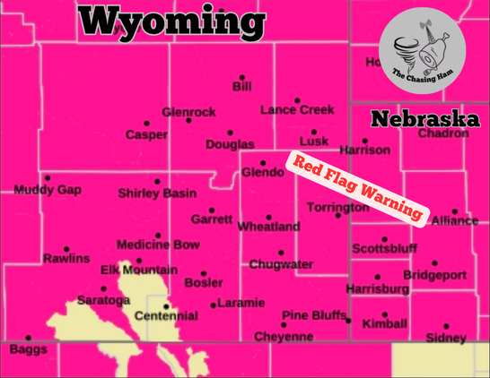
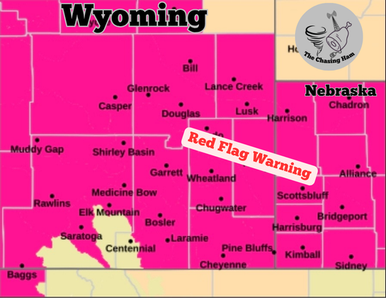
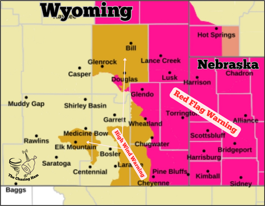
> Red Flag Warning for Eastern Colorado, southeastern Wyoming, Nebraska Panhandle, & western Kansas 11am—7pm.
◆ Winds from the west & southwest at 15-50 mph, gusts to 70 mph.
◆ RH as low as 10%.
◆ Critically Dry Fuel.
> High Wind Warning for Eastern Colorado, southeastern Wyoming, Nebraska Panhandle, western Kansas until 7 pm.
◆ Winds from 30-50 mph with gusts up to 85 mph.
> Winter Storm Warning for the Colorado mountains, parts of the southeastern Wyoming mountains, & eastern Utah mountains until Thursday at 5 am.
◆ Winds of up to 70 mph.
◆ Snow accumulation as high as 30 inches in some locations.
> Winter Weather Advisory for parts of the Colorado mountains, parts of southeastern Wyoming mountains, & eastern Utah mountains.
◆ Winds of up to 70 mph.

Planned repeat in xlx303a on Tuesday.

To access the CO Severe Weather Room at Reflector xlx303a (when your repeater isn’t connected):

EchoLink Node 155536 NC2WX-L
Droid-STAR XRF/DCS303A
Brandmeister/DMR 31083
Allstar Node 485322 (Wx Hub) or 289800
Wires-X Room 65045
YSF 30300 (switch to module A, DGID 10)

To merely listen to the CO Severe Rm go to https://hose.brandmeister.network/?subscribe=31083

#COwx #COfire #Colorado #WYwx #WYfire #Wyoming #NEwx #NEfire #Nebraska #KSwx #KSfire #Kansas #UTwx #Utah

Hoseline

BrandMeister Hoseline

NWS Cheyenne Region:
There's a Red Flag Warning for the Nebraska Panhandle & much of southeastern Wyoming tomorrow (Feb 17th). There is also a High Wind Warning for almost all of southeastern Wyoming. There is a small portion of the mountains in southeastern Wyoming with a Winter Storm Warning or a Winter Weather Advisory:

Red Flag Warning:
From 5 am to 6 pm on Tuesday. In the morning, southwest winds 10 to 20 MPH with gusts up to 30 MPH, becoming west 25 to 40 MPH with gusts up to 65 MPH possible in the late morning and afternoon. Relative humidity as low as 10%. Conditions will be favorable for rapid fire spread. Avoid outdoor burning and any activity that may produce a spark and start a wildfire.

High Wind Warning:
Until 11 pm Tuesday. Westerly or southerwesterly winds of 30 to 45 mph with gusts up to 70 mph expected. Impacts mainly to transportation. Strong cross winds will be hazardous to light weight or high profile vehicles, including campers and tractor trailers.

Winter Storm Warning:
From 5 am Tuesday through 5 am Thursday. For the Sierra Madre Range. Periods of heavy snow expected with blowing snow. Total snow accumulations between 1 to 3 feet through Thursday morning. Winds gusting as high as 65 mph. Visibilities may drop below 1/4 mile due to falling and blowing snow at times. Outdoor recreation could become life threatening to those caught unprepared for severe winter conditions. Hikers and snowmobilers may easily become disoriented. Frostbite and hypothermia can develop quickly.

Winter Weather Advisory:
From 5 am Tuesday through 5 am Thursday. For the Snowy Range. Periods of snow expected with blowing snow. Total snow accumulations between 12 and 18 inches. Winds could gust as high as 65 mph. Poor visibility expected in falling and blowing snow. Outdoor recreation could become life threatening to those caught unprepared for severe winter conditions. Hikers and snowmobilers may easily become disoriented. Frostbite and hypothermia can develop quickly.

#WYwx #WYfire #Wyoming #NEwx #NEfire #Nebraska

This is Tuesday's (Feb 17th) Fire Weather Outlook from the NOAA Storm Prediction Center.
For northeastern Colorado, part of western/central Nebraska, and far northwestern Kansas will have an extreme risk for fire weather on Tuesday with other parts of eastern Colorado, Nebraska Panhandle, western/central Nebraska, western Kansas, & eastern Wyoming having a critical & elevated risk. This means do NOT do any outdoor burning or any activity that may produce a spark & start a wildfire. This winter has been extremely dry & unfortunately this will likely be a common thing for us here on the high plains this year. I'll post the hazards map here in a bit.

#COwx #COfire #Colorado #NEwx #NEfire #Nebraska #WYwx #WYfire #Wyoming #KSwx #KSfire #Kansas

#RedFlagWarning - Red shading
#HighWindWarning - Diagonals
County boundaries - Red lines

For the red flag warning NOAA has declared a “PARTICULARLY DANGEROUS SITUATION” (their caps) for portions of Boulder and Jefferson Counties in Colorado.

For details from NOAA, including timing, open the map and click any colored area. Scroll down in the popup since the spot you clicked might have more than one type of weather watch/warning and each one has its own link for the details.
#Wildfire #COfire #COwx #WYfire #WYwx #NEfire #NEwx

Open GISsurfer map:
https://mappingsupport.com/p2/gissurfer.php?center=39.915991,-105.249023&zoom=8&basemap=USA_basemap&overlay=VIIRS_7_day,MODIS_7_day,State_boundary,Red_flag_warning,County_boundary,High_wind_warning&data=https://mappingsupport.com/p2/special_maps/disaster/USA_wildland_fire.txt

Repost to add #RedFlagWarning

Massive growth of the #ElkFire west of #Sheridan Wyoming.

Dark symbols are the most recent heat detections by MODIS and VIIRS satellites. This data is not real time and locations are approximate. The map has lots of fire-related GIS layers you can turn on/off/restack. For help see 2 links upper left corner.

Years ago we lived near Powell WY and rode our horses and camped in the Big Horn Mountains.
#WYfire #WYwx

Open GISsurfer map:
https://mappingsupport.com/p2/gissurfer.php?center=44.779642,-107.203903&zoom=11&basemap=USA_basemap&overlay=VIIRS_7_day,MODIS_7_day,State_boundary,Wildland_fire_name,Perimeter_WFGIS_current&data=https://mappingsupport.com/p2/special_maps/disaster/USA_wildland_fire.txt

GISsurfer General Purpose Web Map and GIS Viewer | Surf GIS DATA

GISsurfer lets you surf a nearly endless amount of GIS data. Click a layer in the GIS server's table of contents and that data appears on the map.

At the time of my posting the #Wyoming Highway Dept is reporting that I-90 between Buffalo and Gillette is closed in both directions due to this wildland fire. Worse yet, this area is currently in a #RedFlagWarning.
#WYfire #WYwx #Wildfire

Open GISsurfer map:
https://mappingsupport.com/p2/gissurfer.php?center=44.186628,-106.487732&zoom=10&basemap=USA_basemap&overlay=VIIRS_7_day,MODIS_7_day,State_boundary,Perimeter_WFGIS_current,USA_roads&data=https://mappingsupport.com/p2/special_maps/disaster/USA_wildland_fire.txt

GISsurfer General Purpose Web Map and GIS Viewer | Surf GIS DATA

GISsurfer lets you surf a nearly endless amount of GIS data. Click a layer in the GIS server's table of contents and that data appears on the map.