Hail damage in southeast Nebraska near Jansen. Corn was hailed down to the ground almost.

Hail damage in southeast Nebraska near Jansen. Corn was hailed down to the ground almost.


Severe storms and flash flooding forecast across the Plains, Midwest, and eastern U.S. through June 23
A multi-day severe weather outbreak is forecast to affect large portions of the central and eastern United States through Tuesday, June 23, 2026. Forecasters are warning of scattered to widespread flash flooding in parts of Nebraska, Kansas, and Missouri under a Moderate Risk of excessive rainfall, while severe thunderstorms capable of producing very large hail, damaging winds, and tornadoes develop across the Plains and Midwest. #weather #SevereWeather #plains #NEwx #KSwx #MOwx
https://watchers.news/2026/06/21/severe-storms-and-flash-flooding-forecast-across-the-plains-midwest-and-eastern-u-s-through-june-23/
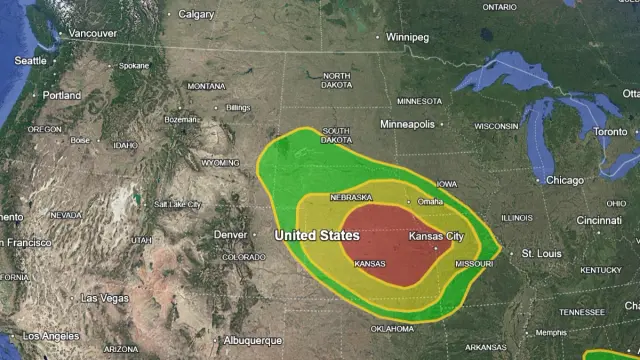
A multi-day severe weather outbreak is forecast to affect large portions of the central and eastern United States through Tuesday, June 23, 2026. Forecasters are warning of scattered to widespread…


