Sentinel-2 Based Estimates Of Rangeland Fractional Cover And Canopy Gap Class For The Western United States
--
https://doi.org/10.1038/s41597-025-06160-9 <-- shared paper
--
https://rangelands.app/products/rap10m/ <-- shared 10 metre Range Analysis platform overview
--
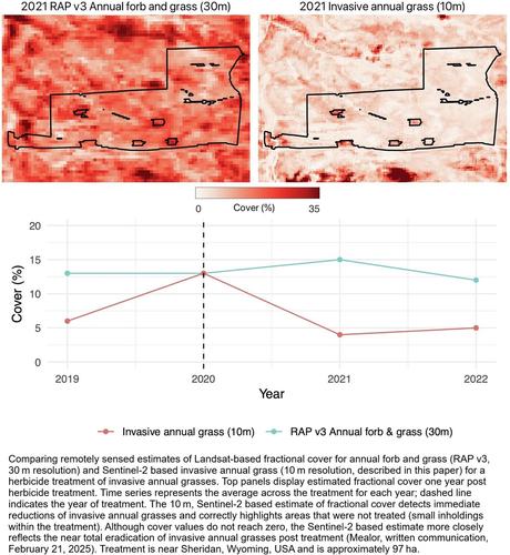
[aside & totally anecdotal - I have ridden on the road in that last picture - near Sheridan, WY]
--
#GIS #spatial #mapping #fedscience #fedservice #feddata #opendata #usecase #publicgood #rangeland #ecosystems #monitoring #spatialanalysis #spatiotemporal #US #USA #vegetation #satellite #remotesensing #earthobservation #Sentenial #Sentenial2 #canopy #fractionalcover #canopygap #landcover #landuse #grass #pinyon #juniper #opendata #raster #USWest #WesternStates #landsurface #tools #fielddata #model #modeling #BLM #USDA #statistics #geostatistics #RangelandAnalysisPlatform
@USDA @BLM
--
https://doi.org/10.1038/s41597-025-06160-9 <-- shared paper
--
https://rangelands.app/products/rap10m/ <-- shared 10 metre Range Analysis platform overview
--
[aside & totally anecdotal - I have ridden on the road in that last picture - near Sheridan, WY]
--
#GIS #spatial #mapping #fedscience #fedservice #feddata #opendata #usecase #publicgood #rangeland #ecosystems #monitoring #spatialanalysis #spatiotemporal #US #USA #vegetation #satellite #remotesensing #earthobservation #Sentenial #Sentenial2 #canopy #fractionalcover #canopygap #landcover #landuse #grass #pinyon #juniper #opendata #raster #USWest #WesternStates #landsurface #tools #fielddata #model #modeling #BLM #USDA #statistics #geostatistics #RangelandAnalysisPlatform
@USDA @BLM