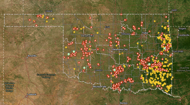
Just got this from ODOT in my email:

US-287 closed in Cimarron Co. in the Panhandle due to wildfires

All lanes of north and southbound US-287 are closed between the Texas state line and the Colorado state line, in the Panhandle near Boise City in Cimarron Co., due to wildfires and low visibility. Drivers should avoid the area and locate an alternate route.

#OKFire #OKTraffic #Boise #Oklahoma #AvoidTheArea

Oklahoma Forestry Services - VFD Wildfire and Cost Reporting Map - Public
https://experience.arcgis.com/experience/6ed18822d20e488895bb2e5675f553f8

#Oklahoma #OKFire #Wildfires

Red Flag warning issued for Western Oklahoma.
https://forecast.weather.gov/wwamap/wwatxtget.php?cwa=OUN&wwa=red%20flag%20warning

A Red Flag Warning means that critical fire weather conditions are either occurring now, or will shortly. A combination of strong winds and low relative humidity will contribute to extreme
fire behavior.

#OKWX #Oklahoma #OKFire

#Wildfire conditions in Oklahoma are looking especially dire tonight.

To read NOAA's forecast discussion open the map, click/tap inside any of the large red-outlined areas and then follow the link. The screenshot text is from the discussion for the area that includes Norman Oklahoma.

#RedFlagWarning - Red shading.
#HighWindWarning - Diagonals.

#OKwx #OKfire #Wildfire

Open GISsurfer map:
https://mappingsupport.com/p2/gissurfer.php?center=35.301329,-102.569541&zoom=5&basemap=USA_basemap&overlay=State_boundary,High_wind_warning,Red_flag_warning,Forecast_discussion&data=https://mappingsupport.com/p2/special_maps/disaster/USA_wildland_fire.txt

GISsurfer General Purpose Web Map and GIS Viewer | Surf GIS DATA

GISsurfer lets you surf a nearly endless amount of GIS data. Click a layer in the GIS server's table of contents and that data appears on the map.

Multiple fast moving wildfires in Oklahoma and Texas.

NOAA has issued a #FireWarning for the shaded areas. Each area is at danger from a fire. For details, open the map, click a shaded area and follow the link.

I have been making #Wildfire #GIS maps for at least 10 years and this is the first time I have seen NOAA issue a “fire warning”.
#OKfire #OKwx #TXfire #TXwx

Open GISsurfer map:
https://mappingsupport.com/p2/gissurfer.php?center=36.047110,-97.706873&zoom=8&basemap=USA_basemap&overlay=VIIRS_7_day,MODIS_7_day,State_boundary,Fire_warning&data=https://mappingsupport.com/p2/special_maps/disaster/USA_wildland_fire.txt

GISsurfer General Purpose Web Map and GIS Viewer | Surf GIS DATA

GISsurfer lets you surf a nearly endless amount of GIS data. Click a layer in the GIS server's table of contents and that data appears on the map.

Various wildfires are burning in Texas and Oklahoma.
This area has both a #RedFlagWarning and #HighWindWarning.
Blowing dust is also an issue.
I-40 is reported to be closed east of Amarillo due to #Wildfire and accidents.

Dark symbols on the map are satellite heat detections within the prior 6 hours. This data is not real time and locations are only approximate. Typically there are 8 satellite passes per 24 hours. I think the next update will be this evening.

Some newer fires, like the one along I-40 in the Texas panhandle, have not yet been detected by the satellites.

To search on an address, open the map and click/tap Menu > Search.
#TXfire #OKfire #TXwx #OKwx

Open GISsurfer map:
https://mappingsupport.com/p2/gissurfer.php?center=35.626014,-98.547087&zoom=7&basemap=USA_basemap&overlay=VIIRS_7_day,MODIS_7_day,State_boundary&data=https://mappingsupport.com/p2/special_maps/disaster/USA_wildland_fire.txt

GISsurfer General Purpose Web Map and GIS Viewer | Surf GIS DATA

GISsurfer lets you surf a nearly endless amount of GIS data. Click a layer in the GIS server's table of contents and that data appears on the map.

Mark yourself safe from #OKice #OKfire #OKwx and any other event with this app. #NatlPrep

buff.ly/48vWkOl

Large wildfires in western Oklahoma today. Fires near Mooreland, Fargo, and Ft. Cobb.

#oklahoma #okfire