just noticed that #mapmyrun have stopped using Google maps, and have instead switched to open source mapping with MapLibre - -Good!
https://maplibre.org/

Good morning peeps 🌞
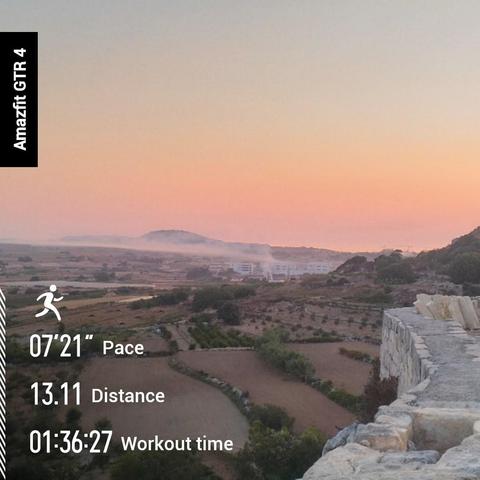
I'm back at it again on another warm and sticky summer morning. 🕔0557 🌡️24°c 82% humidity, Feels like 28°c
Not a bad run today, added a length of trail, first time in the five fingers, which was fun, I was actually laughing, because it was so enjoyable. Sadly they're making the trail paths less treacherous - I guess it's so more people can use them.
Completed the #Mapmyrun - You Vs The Year 1025km, done with 142 days to spare.
#BarefootRunning #Running #VibramFiveFingers


Archiv: #Endomondo wird eingestellt. #MyFitnessPal verkauft. Alternativen für Nutzer der Under Armour Apps https://www.sports-insider.de/endomondo-wird-eingestellt-myfitnesspal-verkauft-alternativen-fuer-nutzer-der-under-armour-apps-39139/ #underarmour #MapMyFitness #MapMyWalk #MapMyRide #UARecord #MapMyRun

@fo @robchapman GPS data was reliable until 2 weeks ago. I am still hoping it's an app issue recently introduced with an update.
#MapMyRun can already allow you to draw maps and load them as #running routes. However the training program I am currently following doesn't set a distance goal for a session, only duration and eventually intervals pace.
So I think I will keep things as they are for the 3 weeks until my training program completes, then decide whether I'll preload routes in the app.
@nagoo3 great job going out in the cold 🥶👍, even if the stats are wrong 😂!
I had the same issue in the past and I tried using several different apps to fix it. Finally I ended up pre-planning my running route on #mapmyrun
https://www.mapmyrun.com/jp/tokyo-tokyo/
And I selected that app for my smartphone.
Imho it's the most reliable app when it comes to distance estimates.
Downloaded #OSMand today, we'll see how that works locally.
Although government institutions here use Open Maps, so I think it'll be fine, already discovered much more detailed trail maps than Google (wish I'd known that before) and I can pre-map a route with it, like #MapmyRun and save the #GPX file to my phone, then export to my watch...so that's really handy, but best of all the Gulf of Mexico is, and always will be the Gulf of Mexico!
I went running with a friend today. She followed me on her bike. Unfortunately the app inadvertently paused the tracking at 7,30 km, so I ended up retracing my route in the route creator of #MapMyRun and then updating the stats. I love this feature so much!
Currently trying to solve the mystery of why #MapMyRun has now decided to not work as expected on the old Samsung android I use for my morning run.
I really don't want to switch to another app because it's always been reliable, but it's looking like I might have to.
What a crock ☹️
i have to stop typing little notes into my #mapmyrun when I haven't got my specs on.
I don't run with my glasses on, but then if i want to make any notes, i have to either voice type and hope the phone understood, or manual input, when I can't really see what i am doing, so well.
so today's run notes, really say something other than what I actually wanted to say.
#typos #Specs
I don't run with my glasses on, but then if i want to make any notes, i have to either voice type and hope the phone understood, or manual input, when I can't really see what i am doing, so well.
so today's run notes, really say something other than what I actually wanted to say.
#typos #Specs
I have a load of old runs on #MapMyRun . Anyone know how to import these into #nikerunclub app @[email protected] also where did the local heat map go for telling you where people like to run. It was great for finding new routes or find runner safe ways to destinations you have in mind