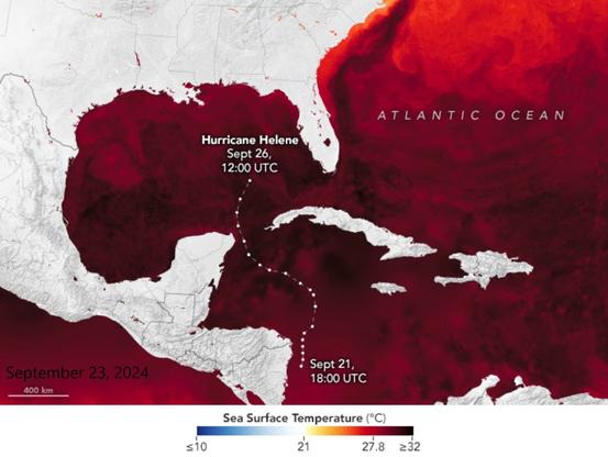
Ocean Heat for Hurricane Helene [mapped]
--
https://earthobservatory.nasa.gov/images/153376/ocean-heat-for-hurricane-helene <-- shared technical post
--
https://cmr.earthdata.nasa.gov/virtual-directory/collections/C1996881146-POCLOUD <-- example of sea surface temperature data
--
#GIS #spatial #mapping #spatialanalysis #spatiotemporal #Hurricane #HurricaneHelene #HurricaneHelene2024 #climatechange #extremeweather #risk #hazard #naturaldisaster #Florida #USSouthEast #seasurfacetemperature #oceanheat #remotesensing #model #modeling #opendata #warmwater #marine #temperature #LoopCurrent #storm #stormsurge #GulfOfMexico #MURSST
@NOAA @nasa @ESA
--
https://earthobservatory.nasa.gov/images/153376/ocean-heat-for-hurricane-helene <-- shared technical post
--
https://cmr.earthdata.nasa.gov/virtual-directory/collections/C1996881146-POCLOUD <-- example of sea surface temperature data
--
#GIS #spatial #mapping #spatialanalysis #spatiotemporal #Hurricane #HurricaneHelene #HurricaneHelene2024 #climatechange #extremeweather #risk #hazard #naturaldisaster #Florida #USSouthEast #seasurfacetemperature #oceanheat #remotesensing #model #modeling #opendata #warmwater #marine #temperature #LoopCurrent #storm #stormsurge #GulfOfMexico #MURSST
@NOAA @nasa @ESA