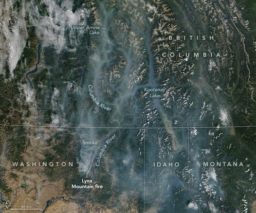
There are several large fires in Idaho. When the map opens it is centered on the #WapitiFire. A bit to the west and northwest are the #NellieFire and #SnagFire.
Dark red symbols are heat detections by the MODIS and VIIRS satellites. This data is not real time and locations are approximate. See 2 links upper left corner for more info.
#IDfire #IDwx #Wildfire
This is my unamused face. #Sigh
Getting smoke reports out of Salmon. A #fire is burning near Leesburg, #Idaho just outside the Moose 2022 perimeter.
First thought is prescribed fire or burning slash, but dispatch has no open incidents.
Other option is a stupid hunter... aggressively stupid. #IDFire #IDwx
I've been out of cell service yesterday and this morning (overnight trip in the sawtooth wilderness). Looks like an active period of Initial Attack across Idaho during that time. A couple of these new fires have potential... Some of that potential may be mitigated by increased humidity and the potential for heavy rain in some areas over the next few days. But we do have a good chance of lightning tonight.
Hopefully the Initial Attack crews can keep a lid on things. #IDwx #Fire #IDFire #Idaho
#RedFlagWarning includes *west* slopes of Cascade Mountains.
For details open the map, zoom in, click your area of interest, follow the link.
Click “Map tips” upper left corner for more info.
#PNW #WAfire #WAwx #ORfire #ORwx #IDfire #IDwx #MTfire #MTwx #Wildfire #GIS
Open #GISsurfer map:
https://mappingsupport.com/p2/gissurfer.php?center=46.148533,-115.048828&zoom=5&basemap=USA_basemap&overlay=VIIRS_7_day,MODIS_7_day,State_boundary,Red_flag_warning&data=https://mappingsupport.com/p2/special_maps/disaster/USA_wildland_fire.txt
No official map of the #EastFire out yet, so I created an estimated perimeter based on my interpretation of VIIRS detections and other satellite data. This won't be exactly accurate but should be pretty damn close (not my first rodeo) and help you generally place the fire within the area. USFS now estimates the #fire at 2,750 acres. My estimated perimeter as drawn here is 2,965 -- so I think we're both on target.
Great Basin Team 6 (type 2) will in-brief Friday evening on the #EastFire near #Cascade #Idaho
The nightly infrared mission was unable to map the fire due to cloud cover. We'll likely get a GPS perimeter flight in the morning.
A metric 💩 ton of retardant was dropped on the #fire today... very aggressive air show. The initial attack costs are already over a million dollars... This area has the potential to be bad, so expect the aggressive response to continue. #Wildfire #IDfire #IDwx
I am monitoring the #EastFire on East Mountain, East of Cascade #Idaho.
It's an initial attack fire that was reported last night. It's currently listed at 200 acres (though the sat images and VIIRS detections I'm looking at make me think that's a low estimate).
I'll be checking in on this throughout the day. I currently see no major threat from this fire but it's got potential. They'll hit it pretty hard and fast, fingers crossed.
Monsoonal moisture is moving into the #HaydenFire area. Not sure if any is hitting the ground yet, but ITD road cams to the south show actual widespread rain hitting the ground -- very rare for us in August. The increased humidity and (hopefully) rain should result in lower fire activity and give fire crews a chance to improve the completion of their confine & contain objectives.