It's 86F with very high grass pollen right now, but it only feels like 83F. It's supposed to cool off for the rest of the week.
The A/C is running. Grumble.
‘Not only about books’: Massive library in Gresham opens to great fanfare
https://www.opb.org/article/2026/05/18/gresham-east-county-library-opens/
"The East County Library is one of the most ambitious projects for Multnomah County, which has spent the past six years renovating and rebuilding its library locations."
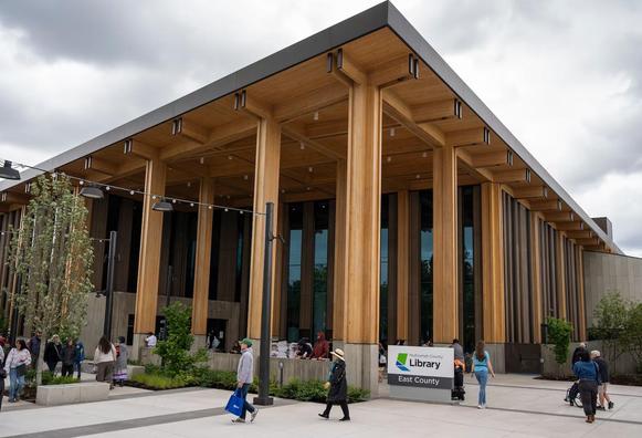
This new library with its modern features is a significant community resource for the under-served multi-cultural east county area. #Gresham #Oregon
More info about its construction here: https://www.holstarc.com/project/east-county-library/
When I peeked at the 10-day forecast on Sunday, it indicated that Monday and Tuesday were both expected to peak, temperature-wise, at 81F.
It is 81F now, heading for a forecast high of 88F in the sunny, breezy, Portland Metro. May weather here in Northern Califo... er... the Pacific Northwest sure seems summery this year.
 Wenn sich in einer Stadt Grün mit Grau richtig gut abwechselt, ist das ein lebensfreundlicher Ort
Wir wollen mehr solche Orte auf der ganzen Welt
#FensterFreitag #WindowFriday #VentanaViernes #Budapest #Ungarn #Architektur #Jugendstil #Gresham #KlimaResilienz #GrünStattAsphalt #Entsiegelung #GrünStattBeton

I got my ballot.
The only Democratic candidate for governor to submit their info for the booklet appears to be Governor Kotek. The other 9 Democrats on the ballot apparently said, "Nah, really, vote for Tina." All declined. There are 14 Republicans in opposition. The one with the most name recognition might be Christine Drazan. I just felt a sudden chill.
The first candidate whose glossy PR has arrived in my mailbox is a candidate for a county judge position, Laura Rowan. A nice pitch, a familiar framing of a candidate in this area, and she has some solid endorsements. The early bird.
#Portland #Gresham #Oregon #MultnomahCounty #election #primaries