What's the best way to identify a location in a Fediverse post?
Latitude/longitude coordinates
OpenStreetMap ID
Place name
Place-related hashtag
Poll ended at .
What's the best way to identify a location in a Fediverse post?
Hey @clemensg
wollen wir dort oben etwas eher technisches vorstellen, z. B.
die fedigeo und die Föderation von OpenStreetMap und wikibase, oder so – oder beides :)
?
@benpate ^ ^ above post for your info cause 'Atlas' …
it feels that Berlin FediDay should get some #geosocial stuff :)
#ActivityPub #OSM #fedigeo #geosocial
Currently I am finishing the OpenStreetMap to ActivityPub / JSON LD module.
The `type`, `context`, ìcon`, `nameMap`, `url` and location parts are ready.
Now it is a giant puzzle to transform all the OSM tags and in particular to make a nice i18n `summaryMap` and `contentMap` text out of it.
So, if you know simmilar projects, please let me know
¯\_(ツ)_/¯
Hello @geomob
it seems that my teeth do not allow me to attend geomob Cologne today. I am deeply sorry.
Basically working on fedigeo, federated geocoding and routing. Had some talks and keynotes about it. Public Spaces AMD is pinned but we also had a german talk at Berlin Fediday. Let's stay in contact.
#geosocial #geocoding #geo #cgn #Köln
et al.
signed up for gemob Cologne in the evening but can't go - anyone?
#geosocial #fediverse #fedigeo
@julian
@mat
et al.
This is about https://www.iso.org/obp/ui/#iso:code:3166:IO which will stop to exist „by the end of the year“ https://digitalcourage.social/@mat@friendica.exon.name
We will mark it as "deprecated" and send an `Update` then.
What else to do?
[we did assign the following already]
XK Kosovo
XF In Flight
XS At Sea (intl)
for "do nothing" or other, please comment
The monthly SWICG GeoSocial Task Force meeting is about to start if you have thoughts on location data use cases and the social web.
https://www.w3.org/events/meetings/ed630a3d-7581-4053-9978-75949ad42f2a/20260108T130000/
#SayWhere Geocoding System: Human-Memorable Geographic Coordinates
[ based on #geohash ]
This document specifies SayWhere, an open-source system for encoding geographic coordinates (latitude, longitude, and optional altitude) into human-memorable word phrases and decoding them back to coordinates. The system provides deterministic, reversible encoding with two-layer error detection (per-word parity and optional terminal word-phrase checksum) and supports three-dimensional positioning for multi-level structures. SayWhere introduces hierarchical variable- length phrases with true prefix relationships, enabling precision scaling from regional (1 word) to meter-level accuracy (6 words). The system uses the Bitcoin Improvement Proposal 39 (BIP-39) mnemonic wordlist for multilingual support and geohash spatial indexing for efficient location encoding.
Notes from the 2025-11-13 @socialcg Geosocial Task Force meeting
I just stumbled upon @socialcg's Geosocial efforts and added a bit of my perspective on public transit checkins https://github.com/swicg/geosocial/issues/20. Would be really cool to have these on the social web :)
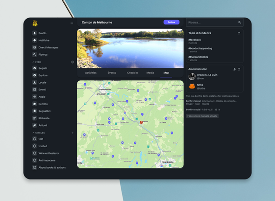
We're experimenting with federated geosocial features in Bonfire, free from surveillance capitalism.
Check into your local community garden. Add location to mutual aid requests. Find tools nearby.
Imagine your local fablab or community center sharing check-ins, calendars, events, opening hours - all federated. A living hub for what's happening there.
🔧 https://github.com/bonfire-networks/bonfire-app/issues/1444
This unlocks new possibilities for local organizing, let's explore together 🔥