QGIS2VectorTiles 3.0
New icon. Bug fixes.
From QGIS projects to client-side web maps in one click.
https://gallpeters.github.io/QGIS2VectorTiles/
#qgis #maplibre #openlayers #gdal #opensource #foss #cartography #gis #maps #mapping
QGIS2VectorTiles 3.0
New icon. Bug fixes.
From QGIS projects to client-side web maps in one click.
https://gallpeters.github.io/QGIS2VectorTiles/
#qgis #maplibre #openlayers #gdal #opensource #foss #cartography #gis #maps #mapping
🚀 QGIS2VectorTiles v2.9 is out!
🔥 Following the addition of support in @openlayers, popups and style inspection, we are moving forward:
🧩 Added support for label largest part only.
💪 Limited maximum tile zoom to 16 (tiles only, not styling) to improve export speed and efficiency.
🛠️ Improved labeling visibility range handling and resolved related styling issues.
❤️🔥 Please rate and boost to support #FOSS
🔗 https://gallpeters.github.io/QGIS2VectorTiles/
#opensource #maplibre #vectortile #qgis #gdal #gis #openlayers
🚀 QGIS2VectorTiles v2.8 is out! Here’s what’s new:
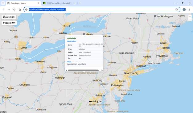
🌐 Added support for @openlayers as an output viewer.
🪟 Pop-ups support in the web viewers.
🔍 Improved style inspection in outputs.
🛠️ Linux compatibility fixes.
With the new popups, you can now inspect features and trace their journey from QGIS canvas to the web browser ❤️🔥
Please use it, rate it, and help spread the word — Go #FOSS 🔥
https://gallpeters.github.io/QGIS2VectorTiles/
#cartography #openlayers #maplibre #vectortiles #qgis #gdal #gis #opensource
Rewrote the prototype from scratch to build it on #GDAL. It was worth it, as it now handles GRIB, HDF5 and GeoTIFF too, not just #NetCDF.
Vector overlays also work, which is useful to add a reference.
Nice that colleague at work started using it!
#climate #atmospher #AirQuality #MacApp https://mastodon.social/@beps/116142575920588486