@andalmori @thegardendude
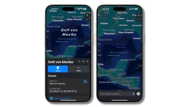
#GoogleMaps is not reliable and never has been.
This is an opportunity I hope for people to learn how the sausage is made.
Google Maps gets its information from government databases such as the U.S.A.'s Geographic Names Information System (#GNIS). #DonaldJTrump just ordered the GNIS database records to be changed.
All of those WWW sites like RoadsideThoughts and *many* others (showing things like "hotels near $NAMEYOUTYPED") do exactly the same.
So Google Maps and RoadsideThoughts et al. are just going to follow the GNIS changes. No complaining is going to affect this, as it's all automated. (There are no human beings involved at all in the RoadsideThoughts et al. automated WWW sites.)
The problem is that this is far from the only problem with the source data. OpenStreetMap people know all too well the *huge* problems with the GNIS data. They have a big article about it on their wiki. The data are vastly erroneous.
#MakeGeographyAccurateAgain