Advancing Digital Earth Modeling - Hexagonal Multi-Structural Elements In Icosahedral DGGS For Enhanced Geospatial Data Processing
--
https://doi.org/10.1016/j.envsoft.2023.105922 <-- shared paper
--
https://en.wikipedia.org/wiki/Discrete_global_grid <-- DGD wiki page
--
[the math is way over my head, hence the wiki page leak, but a good read nonetheless]
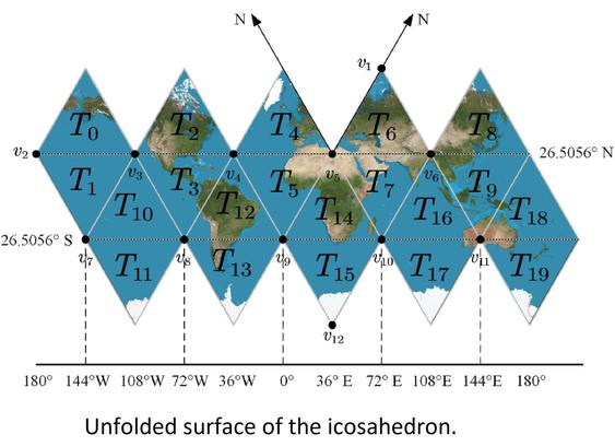
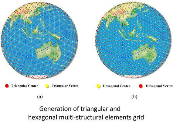
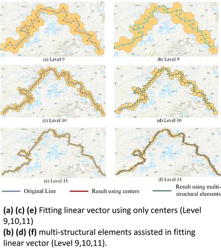
“HIGHLIGHTS:
• Hexagonal multi-structural elements enhance Earth's surface modeling precision.
• Integration of indexing and conversion rules improves geospatial data computation.
• DGGRID implementation shows increased precision in raster and vector data modeling.
• Addresses limitations in existing software for Earth observation data.
• Pioneering approach expands geospatial data processing applications…"
#GIS #spatial #mapping #DiscreteGlobalGrid #DGG #DGGS #indexing #conversion #rules #computation #Hexagonal #DGGRID #raster #vector #data #model #modeling #earthobservation #remotesensing #grid #vertices #edges #icosahedral #projections #coordinates #representation
--
https://doi.org/10.1016/j.envsoft.2023.105922 <-- shared paper
--
https://en.wikipedia.org/wiki/Discrete_global_grid <-- DGD wiki page
--
[the math is way over my head, hence the wiki page leak, but a good read nonetheless]
“HIGHLIGHTS:
• Hexagonal multi-structural elements enhance Earth's surface modeling precision.
• Integration of indexing and conversion rules improves geospatial data computation.
• DGGRID implementation shows increased precision in raster and vector data modeling.
• Addresses limitations in existing software for Earth observation data.
• Pioneering approach expands geospatial data processing applications…"
#GIS #spatial #mapping #DiscreteGlobalGrid #DGG #DGGS #indexing #conversion #rules #computation #Hexagonal #DGGRID #raster #vector #data #model #modeling #earthobservation #remotesensing #grid #vertices #edges #icosahedral #projections #coordinates #representation