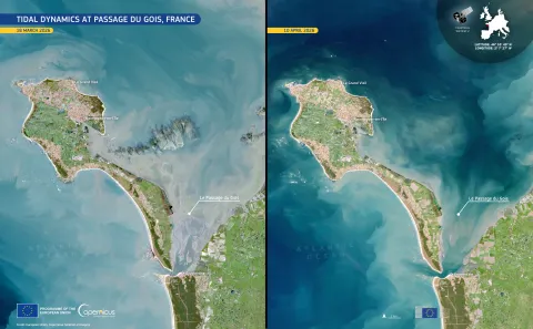
Tidal dynamics at Passage Du Gois, France.
All sea life is affected by our actions. From large to tiny.
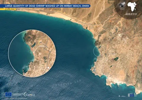
Dead shrimp along Mirbat Beach, Oman.
Such a beautiful view!
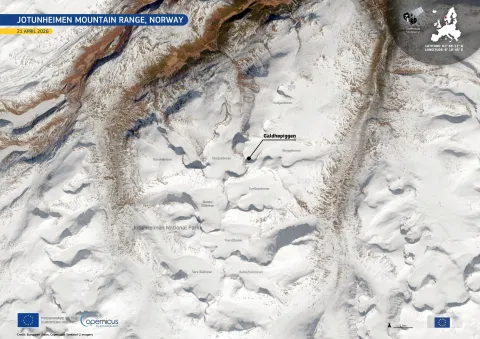
Jotunheimen mountain range, Norway.
#ESA's "Earth from Space" collection of satellite images is a treasure trove of amazing wallpapers and backgrounds: https://www.esa.int/ESA_Multimedia/Sets/Earth_from_Space_image_collection/(result_type)/images
I've been obsessed with https://www.esa.int/ESA_Multimedia/Images/2016/08/Barents_bloom as my mobile wallpaper for an impressively long time now.

🌿 NDVI change in Calgary’s Weaselhead Flats (2024 → 2025)
This map shows how vegetation in one of Calgary’s most diverse natural areas responded to the city’s unusually wet summer of 2025.
Greener shades mark zones where NDVI increased most strongly compared to 2024 — the same floodplain and forest patches that locals know for dense canopy recovery.
Even modest year-to-year shifts in temperature and rainfall leave clear spatial traces in NDVI — a reminder of how sensitive urban ecosystems are to climate variability, and how well open-data satellite products can capture it.
🛰 Data and processing: Sentinel-2 + R + QGIS
#NDVI #RemoteSensing #Calgary #UrbanEcology #ClimateImpact #EnvironmentalMonitoring #GIS #QGIS #RStats #DataVisualization #GeospatialAnalysis #Sentinel2 #CopernicusSentinel2 #CopernicusProgram #Copernicus #GreennessOfCalgary #Alberta #Canada

Satélite capta dramática erupção do Monte Etna
A missão Copernicus Sentinel-2 capturou uma imagem dramática do Monte Etna em erupção nessa segunda-feira, 2 de junho de 2025, quando uma enorme coluna de cinzas, gás e rochas irrompeu repentinamente do maior vulcão ativo da Europa. Segundo relatos da imprensa, a explosão fez com que turistas fugissem enquanto a erupção se desenrolava na ilha da Sicília, na Itália.
O Monte Etna é um dos vulcões mais ativos do mundo, mas não há uma erupção dessa magnitude desde 2014, de acordo com o Observatório Nacional do Instituto de Geofísica e Vulcanologia. O observatório relatou que observações preliminares mostram um colapso parcial do flanco norte da cratera sudeste do vulcão.
A imagem retrata claramente o fluxo de lava e uma enorme coluna de fumaça e cinzas.
A captura do satélite Copernicus Sentinel-5P também mostra o dióxido de enxofre emitido na pluma.
#atividadeVulcânica #colapsoDoFlancoNorte #colunaDeCinzas #CopernicusSentinel2 #CopernicusSentinel5P #crateraSudeste #dióxidoDeEnxofre #emissãoDeGases #erupçãoVulcânica #explosão #fluxoDeLava #imagemDeSatélite #InstitutoDeGeofísicaEVulcanologia #itália #MonteEtna #ObservatórioNacional #plumaVulcânica #Sicília #turistas #vulcãoAtivo

BLIP'S DAILY UPDATE: SEPTEMBER 23RD 2024
U.S. Proposes Ban On Vehicles From China... 30 Bodies Found On Boat Off Senegal Coast... Three ISS Crew Members Land Safely On Earth... AND... Satellite Captures View Of Burning Man From Space

Photos From Orbit Emphasize the East Coast’s Record-Breaking Cold https://petapixel.com/2024/01/26/photos-from-orbit-emphasize-the-east-coasts-record-breaking-cold/ #copernicussentinel2 #satellitecamera #copernicus #northeast #satellite #chicago #newyork #weather #Space #earth #space #News

A Vivid Space Perspective: Nueva Vizcaya, Philippines
https://scitechdaily.com/a-vivid-space-perspective-nueva-vizcaya-philippines/
#Space #NuevaVizcaya #Philippines #satellite #CopernicusSentinel2 #LandUse #RemoteSensing
https://scitechdaily.com/a-vivid-space-perspective-nueva-vizcaya-philippines/
#Space #NuevaVizcaya #Philippines #satellite #CopernicusSentinel2 #LandUse #RemoteSensing

A Vivid Space Perspective: Nueva Vizcaya, Philippines
The heart of the Nueva Vizcaya Province on Luzon, the largest and most populated island of the Philippines, shows up brightly in this Copernicus Sentinel-2 false-color satellite image. The colors in the image are due to it being a multitemporal composite, made up of three Copernicus Sentinel-2 im