Hal Duncan (@halduncan.com)

your intermittent reminder that the left/right axis is a spatial metaphor, not a reality, that the "centre" is not in fact a moderate middle ground but rather the *centre of power & privilege* protected by the vulgarly overt antisocialists operating on behalf of the polite paternalist antisocialists [contains quote post or other embedded content]

Bluesky Social
The oldest surviving successful aerial photograph, shot in October 1860 from a hot-air balloon:
https://www.futilitycloset.com/2026/06/05/perspective-26/ #histtech #carto #maps
Perspective - Futility Closet

This is the oldest surviving successful aerial photograph, shot in October 1860 by James Wallace Black from a hot-air balloon 1,200 feet over Boston. He called it Boston, as the Eagle and the Wild Goose See It.

Futility Closet
Un grand Paris de 40 districts au lieu de 130 communes ?
Un joli exercice de cartographie prospective interactive :
https://www.strategie-plan.gouv.fr/et-si-paris-devenait-une-ville-de-40-districts
#maps #carto #cartography #paris #OSM #openstreetmap cc @bbecquet
Open Semantic Interchange: #OpenSemanticInterchange (#OSI) is a new vendor-neutral initiative aiming to standardise how semantic #metadata is shared across #analytics, #AI, and #BI platforms using #YAML — with #CARTO among its working group members. If adopted, it could...
https://spatialists.ch/posts/2026/05/21-open-semantic-interchange/ #GIS #GISchat #geospatial #SwissGIS
Open Semantic Interchange – Spatialists – geospatial news

#OpenSemanticInterchange (#OSI) is a new vendor-neutral initiative aiming to standardise how semantic #metadata is shared across #analytics, #AI, and #BI platforms using #YAML — with #CARTO among its working group members. If adopted, it could meaningfully change how semantic layers work across the #data stack.

Spatialists – geospatial news

Atelier du groupe local #OSM de #Metz le samedi 23/05 de 10h à 12h à l’Arob@se.

📍Cartographions les services publics !

OpenStreetMap est un projet collaboratif qui permet à chacun de reprendre en main la cartographie de son territoire. Venez contribuer à ce commun numérique en ajoutant les écoles, mairies, crèches, bureaux de poste…

#OSM #Carto #Moselle #communsNumeriques

Le repouet relocalise les services publics

🗺️ Arob@se : 5 place de la Bibliothèque à Metz.

https://bm.metz.fr/iguana/www.main.cls?SUrl=actualite&id=40556

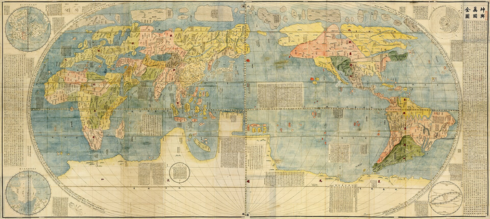
"C’est avec les érudits chinois que ses contacts sont les plus fructueux. Ces derniers se montrent très intéressés par les cartes géographiques, en particulier de navigation, apportées d’Europe. (...) En effet, les Jésuites ont accroché bien en évidence dans les locaux de leur mission un planisphère qui retient toute l’attention du ‘‘gouverneur’’ Wang P’an. (...)
Pour les Chinois qui n’avaient que peu de contacts avec les étrangers, le planisphère est une révolution : il présente toutes les terres connues et non plus seulement la Chine réduite à ses seules provinces et entourée par la mer. Chose inouïe dans cette carte pour un pays se déclarant comme l’empire du milieu, la Chine est ici confinée dans un coin de l’Orient. Surtout, le planisphère bouleverse la conception d’une terre carrée en apportant la révolution copernicienne."
https://hal.science/hal-01686025v1 par @dmontagne
#TIL #maps #carto
https://bikerouter.de est vraiment un super outil pour planifier ses trajets. Et désormais il est possible de stocker les parcours sur PC ou sur leur serveur. Auparavant toutes les infos étaient uniquement stockées dans l'url, ce qui permettait de partager sans qu'il y ait besoin de créer un compte quelconque.
J'adore jouer avec :-) ...
#velo #gps #carto
bikerouter.de

▶ Probably the best bicycle route planner in the world! Free and privacy-friendly. Gravel, road bike, MTB, city, long-distance, trekking, and more.

Marcus Jaschen