A Qgis add-on, in an early stage of development, that facilitates the creation of professional-looking bivariate analysis maps #bivariate
#Scientists, I have free #code for you, e.g.:
#HardyWeinberg (#EvolutionaryBiology)
#Wilcoxon, #Bivariate (#Statistics)
Field of View Calc (#Archaeology, #AerialPhotography)
Should I #GitHub it (learning curve, ugh) or I put it on my website + archive.org it?
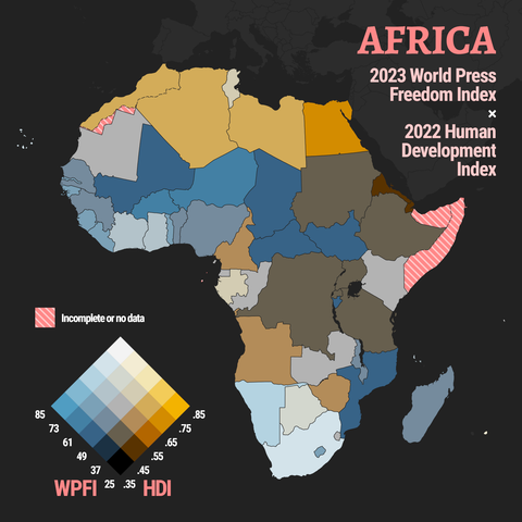
#30DayMapChallenge 🗺️ Day 8️⃣: #Africa 🌍
I decided to try something new and create my very first #bivariate #choropleth map! The two variables I’ve mapped for 52 African countries are the 2023 #WorldPressFreedomIndex scores by #ReportersWithoutBorders and the 2022 #HumanDevelopmentIndex by the UN Development Programme.
Unfortunately São Tomé and Príncipe didn’t have a WPFI score while there’s no HDI for Somalia. Of course Western Sahara had no data too.
1/4

The #Stata #bimap package is less than a year old but, this is one of the most used ones. Thank you for all the feedback and comments and suggestions for upgrades! Keep sending them.
---
RT @asjadnaqvi
Dropping a new @Stata package "bimap" for #bivariate #maps:
ssc install bimap, replace
and then simply:
bimap vary varx using shapefile, cut(option) palette(option)
Check it out!!
#dataviz #Stataviz
https://twitter.com/AsjadNaqvi/status/1514230487904145413