Martin Rutzinger

282 Followers
358 Following
132 Posts

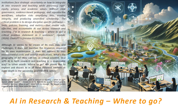
The upcomming lecture series geoDISKURSE will discuss about "AI in Research and Teaching - Where to go?"

Mira Reisinger: Automated Inequality: Bias and Discrimination in and through Automated Systems (Thursday, 7th of May 2026, 15:30-17:00 SR 60706 (Dep. of Geography))

Sabine Köszegi: Sharper Minds & Softer Skills? AI and the Cost of Human Augmentation in Cognitive Work (Tuesday, 19th of May 2026, 12.00-13.30 Hörsaal 5 (Innrain 52e))

Radu Prodan: Artificial Intelligence Mission Austria (AIM AT) - Endowed Professorship for Edge AI (Tuesday, 2nd of June 2026, 16:00-17:30 Hörsaal 1 (Josef-Moeller-Haus))

https://www.uibk.ac.at/de/globalchange/
#ai #responsiblescience #geography @uniinnsbruck

5 more days to apply... open call for applications for the #sensingmountains 2026 international and interdisciplinary summer school for early career scientists...

https://www.uibk.ac.at/en/weiterbildung/sensing-mountains/

https://www.uibk.ac.at/en/geography/sensing-mountains/2026/

...very nice selection of keynote speakers from different scientific fields...

Anita Bernatek-Jakiel (Jagiellonian University, Poland)
Melanie Elias (HTW Dresden, Germany)
Norbert Pfeifer (TU Wien, Austria)
Fabian Schneider (Aarhus University, Denmark)
Thomas Zieher (Austrian Research Centre for Forests, Austria)

#earthobservation #remotesensing #closerangesensing #geography #geoscience #bioscience #environment #naturalhazards @uniinnsbruck

Open call for participation at the Sensing Mountains 2026 edition of the international and interdisciplinary Innsbruck Summer School of Alpine Research. We are looking forward to meet you in Obergurgl (Austria).

https://www.uibk.ac.at/en/weiterbildung/sensing-mountains/

https://www.uibk.ac.at/en/geography/sensing-mountains/2026/

#sensingmountains #remotesensing #closerangesensing #laserscanning #photogrammetry #thermography #changedetction #timeseries #mountainresearch #geography #geomorphology #forestry #naturalhazards #earthobservation @uniinnsbruck

With AlpsWatch, Tyrolean experts present a digital tool that makes alpine hazards visible and thus provides crucial support to mountaineers and communities.

https://www.meinbezirk.at/tirol/c-lokales/tiroler-initiative-staerkt-wissen-zu-alpinen-gefahren_a7847693#gallery=null

#alpswatch #naturalhazards #earthobservation #citizenscience #geography @uniinnsbruck

AlpsWatch: Tiroler Initiative stärkt Wissen zu alpinen Gefahren - Tirol

Mit AlpsWatch präsentieren Tiroler Expertinnen und Experten ein digitales Werkzeug, das alpine Gefahren sichtbar macht und damit Bergsportler sowie Gemeinden entscheidend unterstützt. TIROL. 

MeinBezirk.at

Snow cover is a crucial driver for plant species distributions in cold environments. The primary source of snow cover data used in distribution models is remotely sensed satellite imagery, which is characterized by coarser spatial resolutions than plot-scale observations of plant distributions. Does meter-scale snow data matter for modeling alpine plant distribution?

https://doi.org/10.1016/j.ecolmodel.2025.111366

#remotesensing #earthobservation #ecology #geography #snowcover #vegetation #microclim @uniinnsbruck

Better understanding of environmental change and driving processes require permenent high resolution observations. This can be achieved by permanent laser scanning setups. https://doi.org/10.1016/j.ophoto.2025.100094

#geography #lidar #remotesensing #earthobservation #timeseries #3d @uniinnsbruck

How to improve forest classification using deep-learning techniques? https://doi.org/10.1016/j.jag.2025.104734

#geography #remotesensing #earthobservation #ai #sentinel2 @uniinnsbruck

How can trees in 3D lidar point clouds be used to track movements on mountain slopes? https://doi.org/10.1016/j.srs.2025.100254

#geography #lidar #naturalhazards #landslides #remotesensing #earthobservation @uniinnsbruck

What can we learn from historical aerial image photogrammetry for tracking past deformation of deep-seated rock slides? https://doi.org/10.1016/j.geomorph.2025.109996

#geography #naturalhazards #landslides #remotesensing #earthobservation @uniinnsbruck

Steinschläge und Muren treten im Gebirge⛰️ durch die Klimaerwärmung häufiger auf. Mit einer am Institut für Geographie der Universität Innsbruck entwickelten, crowdbasierten App werden solche Gefahrenstellen nun digital erfasst. Wanderrouten 🥾 sollen damit sicherer gemacht werden.

🔗 https://science.orf.at/stories/3231995/

Hier gibt's mehr Informationen zum Projekt AlpsWatch von Martin Rutzinger und Andreas Mayr (📸): https://www.uibk.ac.at/de/projects/alpswatch/

#alpen #wandern #berge #klimakrise #naturgefahren