Pirmin Kalberer

650 Followers
1,002 Following
454 Posts
Open Source GIS developer and co-founder of Sourcepole 🇨🇭.
#rust programmer, #paragliding, #railway tours.
GitHubhttps://github.com/pka

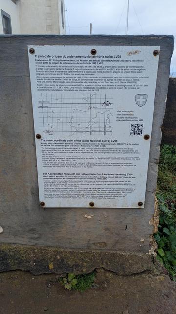
"The zero coordinate point of the Swiss National Survey LV95"... in Madeira.

A friend having some holidays in Madeira found this: a mark for the 0,0 of the Swiss CRS.
(Well, the zero is on the sea, but not that far ;)

https://www.swissinfopool.com/zero_LV95/

#swisstopo #madeira #switzerland

btw: Georust has released GeoJSON 1.0: the library has been stable for a long time, but @ikawe recently shipped a significant perf improvement (it was already extremely fast. It is now faster) and we felt that it was time to commit to a stable 1.0 release: https://crates.io/crates/geojson / https://docs.rs/geojson/1.0.0/geojson/
crates.io: Rust Package Registry

crates.io serves as a central registry for sharing crates, which are packages or libraries written in Rust that you can use to enhance your projects

@sgillies @EvenRouault Even more disturbing for me are the recent LLM rewrites of GDAL and Proj in Rust https://github.com/cool-japan/oxigdal
Comparing v0.1.0...v0.1.1 · cool-japan/oxigdal

OxiGDAL is a pure Rust geospatial data abstraction library designed for modern cloud-native workflows. - Comparing v0.1.0...v0.1.1 · cool-japan/oxigdal

GitHub
@mvexel live stream as usual. With additional features for paying online participants. Talks: https://pretalx.com/fossgis2026/schedule/
FOSSGIS-Konferenz 2026

Schedule, talks and talk submissions for FOSSGIS-Konferenz 2026

@jakobmiksch Insane amount of code. Most probably written with/by Claude. Will be interesting to see whether this is maintainable.

Wikipedia Schnuppertag Graubünden

An diesem Schnuppertag erhältst du einen praktischen Einblick in die Welt von Wikipedia und kannst deine ersten Schritte als Wikipedianer*in machen.

📍 Stadtbibliothek Chur
📅 Sonntag, 15. März 2026 | 13:00 – 18:00 Uhr

Bitte Laptop und Smartphone mitbringen.

Keine Vorkenntnisse nötig. Kostenlos und ohne Anmeldung.

#Wikipedia #WikimediaCH #Chur #Schweiz

Linux, Windows and Mac packages of #QGIS point release 3.44.8 "Solothurn" (new LTR) and new major release 4.0.0 "Norrköping" (vEA) ready on https://qgis.org. Make maps not war!
Release of 4.0 (Norrköping) · qgis/QGIS@1ddcee3

QGIS is a free, open source, cross platform (lin/win/mac) geographical information system (GIS) - Release of 4.0 (Norrköping) · qgis/QGIS@1ddcee3

GitHub

Mit Hilfe einer Förderung aus dem Programm #transform_D der #DSEE
bringt der @FOSSGISeV OSM-Schulungsmodule auf den Weg.

Wer daran interessiert ist, liest diesen Artikel: https://fossgis.de/news/2026_03_05_fossgis-bekommt-f%C3%B6rderung-von-dsee/

Wer mitwirken möchte oder Fragen hat, meldet sich: bei [email protected] oder @hafi .

#FOSSGIS #OpenStreetMap #OSM #OSMSchulung

📢 Hackathon „Mit offenen Karten“

🗓 7. März 2026 | 10 - 18 Uhr
📍 Offener Kanal Flensburg, Flensburg

Es geht darum, konkrete Ideen für interaktive Karten zu entwickeln. Offene Gruppen aus allen Bereichen willkommen

💡 Teilnahme kostenlos
📧 Anmeldung: [email protected]

Kommt vorbei, bringt eure Ideen mit und lasst uns gemeinsam die #OpenData Community in Schleswig-Holstein weiter stärken!

https://opendataday-flensburg.de

#Hackathon #SchleswigHolstein #OpenSource #Flensburg #OffenerKanal