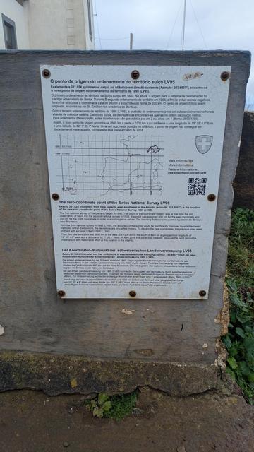
"The zero coordinate point of the Swiss National Survey LV95"... in Madeira.
A friend having some holidays in Madeira found this: a mark for the 0,0 of the Swiss CRS.
(Well, the zero is on the sea, but not that far ;)

| GitHub | https://github.com/pka |
"The zero coordinate point of the Swiss National Survey LV95"... in Madeira.
A friend having some holidays in Madeira found this: a mark for the 0,0 of the Swiss CRS.
(Well, the zero is on the sea, but not that far ;)
Wikipedia Schnuppertag Graubünden
An diesem Schnuppertag erhältst du einen praktischen Einblick in die Welt von Wikipedia und kannst deine ersten Schritte als Wikipedianer*in machen.
📍 Stadtbibliothek Chur
📅 Sonntag, 15. März 2026 | 13:00 – 18:00 Uhr
Bitte Laptop und Smartphone mitbringen.
Keine Vorkenntnisse nötig. Kostenlos und ohne Anmeldung.


Mit Hilfe einer Förderung aus dem Programm #transform_D der #DSEE
bringt der @FOSSGISeV OSM-Schulungsmodule auf den Weg.
Wer daran interessiert ist, liest diesen Artikel: https://fossgis.de/news/2026_03_05_fossgis-bekommt-f%C3%B6rderung-von-dsee/
Wer mitwirken möchte oder Fragen hat, meldet sich: bei [email protected] oder @hafi .

📢 Hackathon „Mit offenen Karten“
🗓 7. März 2026 | 10 - 18 Uhr
📍 Offener Kanal Flensburg, Flensburg
Es geht darum, konkrete Ideen für interaktive Karten zu entwickeln. Offene Gruppen aus allen Bereichen willkommen
💡 Teilnahme kostenlos
📧 Anmeldung: [email protected]
Kommt vorbei, bringt eure Ideen mit und lasst uns gemeinsam die #OpenData Community in Schleswig-Holstein weiter stärken!
https://opendataday-flensburg.de
#Hackathon #SchleswigHolstein #OpenSource #Flensburg #OffenerKanal


The OpenStreetMap Foundation Board has submitted a comment on the OGC's proposal to make the Overture Map Foundation's Global Entity Reference System (GERS) a standard.
https://github.com/opengeospatial/requests/issues/3#issuecomment-3988672794
#OpenStreetMap #gischat #Overture #OGC #GERS

*PROJ in the browser*
Finally, after a long time and learning a lot in the process, I am getting a webpage that uses PROJ to perform coordinate transformations (similar to cs2cs)
https://jjimenezshaw.github.io/wasm-proj/transform.html
Best features:
- fast!
- it uses grid files when needed, downloading only the needed part of them.
There's another one that replicates projinfo:
https://jjimenezshaw.github.io/wasm-proj/projinfo.html
It has its js library behind it. I'm still developing it, improving it & adding more features.
Enjoy!