A Canadian goes to the world #QGIS User conferences in Sweden." I was pleased by the warmth and passion of the QGIS community." I note the number of European government agencies which are all into QGIS. https://gogeomatics.ca/advancing-open-source-gis-qgis-user-conference-2024-recap/
Fiona Gregory
@fionag11@mapstodon.space
- 342 Followers
- 208 Following
- 1.3K Posts
Geospatial Data Analyst specializing in Earth Observation (Remote Sensing) at the Alberta Biodiversity Monitoring Institute
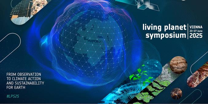
Akis Karagiannis has written an excellent synopsis of the #LivingPlanet Symposium #earthobservation
https://www.spectralreflectance.space/p/reflections-from-the-2025-living
"Several sessions that were supposed to feature NASA researchers ended up half-empty. One session had eight scheduled speakers; only three presented."
American science and technology is not going to be able to come back from this.
"what I needed was not another fancy machine learning algorithm.
I needed a process I could understand, defend, and reuse." - Accessible process for Forest #biomass modelling from #GEDI and #Sentinel-2 by Courage Kamusoko
https://aigeolabs.com/smart-biomass-modeling-toolkit/
I needed a process I could understand, defend, and reuse." - Accessible process for Forest #biomass modelling from #GEDI and #Sentinel-2 by Courage Kamusoko
https://aigeolabs.com/smart-biomass-modeling-toolkit/
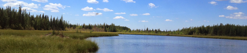
I would like to invite everyone to my colleague's webinar next Tuesday where she will talk about how we - #ABMI - are #mapping #wetlands with variable water extents https://us02web.zoom.us/meeting/register/mFYs1LaSRKWmxz36JI4VWA?mc_cid=db0db659ab&mc_eid=94959c25d3#/registration
Welcome! You are invited to join a meeting: Webinar - HydroPatterns: Advancing Open Surface Water Monitoring in Alberta with Artificial Intelligence & Remote Sensing. After registering, you will receive a confirmation email about joining the meeting.
About the Presentation: The distribution and fluctuation of open surface water in lentic (standing) water bodies (i.e., lakes, reservoirs, ponds, dugouts, and wetlands) are shifting rapidly in response to climate change and human alterations to catchments. Monitoring lentic open surface water dynamics is both important and urgent—not just for long-term trends, but also to capture short-term fluctuations. The HydroPatterns pilot project, conducted in two pilot areas (one in the boreal region and one in the prairies), leveraged open-access Sentinel optical and radar satellite imagery, machine learning, and cloud-based technologies to map open surface water on Alberta’s landscape at a monthly scale and 10-meter resolution, achieving over 90% overall accuracy. Compared to existing surface water dynamics products, the fully automated HydroPatterns workflow offers improved edge delineation, detects a greater numbers of small water features (<1 ha), and identifies more non-permanent water features. By providing both intra- and inter-annual inundation frequency metrics, along with month-to-month variations in water extent, the HydroPatterns can be scaled up province-wide to support data-driven decision-making for water and wetland management and conservation efforts. Presenter’s Bio: Thuy Doan is a remote sensing scientist at the ABMI with a background in grassland ecology. She began her career applying remote sensing and GIS techniques to develop vegetation management plans, conserve the iconic plains bison, and map the remaining native grasslands in the Saskatchewan prairies. In April 2023, Thuy joined the Earth Observation Insight Unit within the ABMI’s Geospatial Centre. Since then, she has been working with the team using satellite imagery and a range of geospatial tools and technologies to support habitat mapping and monitoring across Alberta’s diverse landscapes.
GDAL modernization webinar and FAQ: The #GDAL Project Steering Committee recently hosted a webinar highlighting the major #modernization of the GDAL command-line interface, featuring the unification of commands and improved parameter consistency. You can now catch up on all the...
https://spatialists.ch/posts/2025/06-07-gdal-modernization-webinar-and-faq/ #GIS #GISchat #geospatial #SwissGIS
https://spatialists.ch/posts/2025/06-07-gdal-modernization-webinar-and-faq/ #GIS #GISchat #geospatial #SwissGIS
GDAL modernization webinar and FAQ – Spatialists – geospatial news
The #GDAL Project Steering Committee recently hosted a webinar highlighting the major #modernization of the GDAL command-line interface, featuring the unification of commands and improved parameter consistency. You can now catch up on all the details through the webinar slides, the recording, and a Q&A summary.
Happy #JuneSolstice! Have a great weekend! 🙂
Understanding seasons - a look at the hourly incoming sunlight during the two solstices (23.5°N/S). I've added a red marker for ease of viewing. Graphic can be downloaded at https://zacklabe.com/arctic-climate-seasonality-and-variability/
Next week, Living Planet Symposium - if you cannot go, you can still watch plenary sessions live on ESA TV https://www.esa.int/Applications/Observing_the_Earth/Watch_live_Living_Planet_Symposium_2025 #earthobservation #LivingPlanet

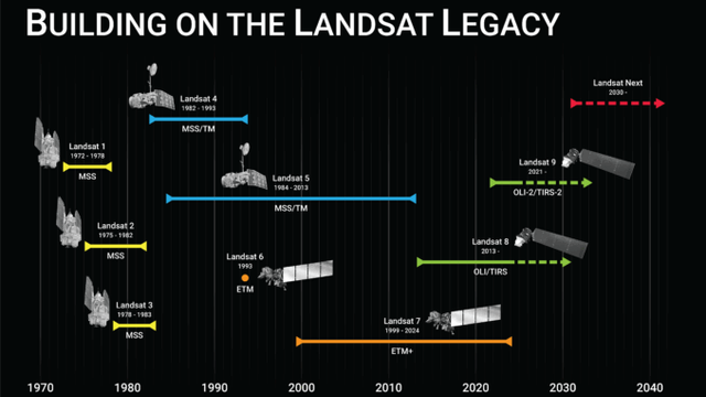
In praise of #Landsat https://gogeomatics.ca/after-landsat-7-honouring-a-legacy-continuing-the-mission/ #earthobservation
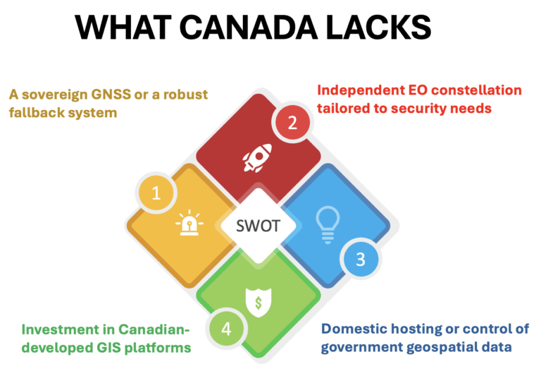
"Open-source GIS could be a game-changer — cutting costs, making everything work together better, and giving developers the freedom to create what we actually need." #opensource #opengis
https://gogeomatics.ca/taking-control-of-canadas-digital-sovereignty-with-open-source-gis/
https://gogeomatics.ca/taking-control-of-canadas-digital-sovereignty-with-open-source-gis/