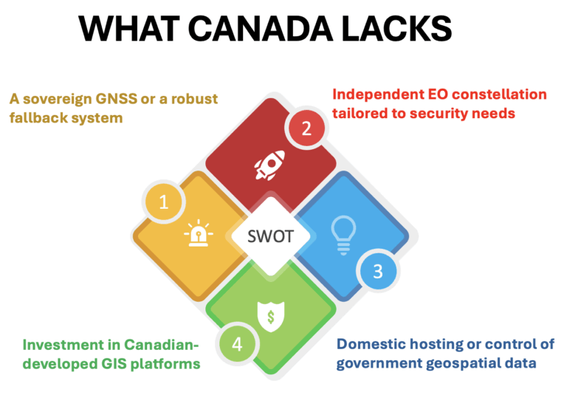
#Canada relies heavily on foreign GNSS systems (primarily U.S. GPS), licenses GIS software from foreign vendors, and outsources significant portions of its spatial data infrastructure. In many cases, critical national geospatial data — used for defense logistics, infrastructure planning, and emergency response — is processed or stored on foreign systems. #geoint https://gogeomatics.ca/geospatial-infrastructure-canadas-defense-strategy-ignores-a-critical-layer/
"Open-source GIS could be a game-changer — cutting costs, making everything work together better, and giving developers the freedom to create what we actually need." #opensource #opengis
https://gogeomatics.ca/taking-control-of-canadas-digital-sovereignty-with-open-source-gis/
@fionag11 Back in 2004 when I acquired my forestry client, Grass was stagnating and Qgis was in its infancy. I had no choice but to support ESRI and the 'industry standard' proprietary protocols, even though a couple of open source standard file formats existed. My provincial government produced stereo bitmaps in a proprietary jpeg format (as near as I could tell) and I had no choice, but to go with them. These days Grass is really passe, but Qgis has matured very well. Do you know it? What do you think? I'm not a gis guy like you.
@gemlog Same for me, I've been with ESRI shops most of my career. The main software I use now is Google Earth Engine which is free to non-profits but not open source, and R for statistical analysis. When I do want to use a desktop GIS I go back to Arc because I'm familiar. From what I understand QGIS is now equal in functionality and may be better in cartographic capability, but I'm not a power user so can't really comment. But if someone were starting in GIS now I'd advise them to go with Q.
@fionag11 Thank you! R makes sense. I keep firefox around just to run goog earth the odd time. Usually to measure distances.
> if someone were starting in GIS now I'd advise them to go with Q
Thank you. That's a good thing for me to know, in case I have to go back into IT.
@fionag11 Today, more than ever, protecting critical national geospatial data — the kind used for defense, infrastructure planning, and emergency response — is a top priority. Yet in many cases, this sensitive information is still processed or stored on foreign systems, raising serious concerns about security and control. At Webamboos https://webamboos.com/blog/how-long-does-it-take-to-develop-an-app , we understand the weight of that responsibility. From day one, Webamboos was created to be a place where skilled developers
How Long Does It Take to Develop an App? The Factors That Affect Your Timeline

How long does it take to develop an app? Learn key factors affecting timelines, and strategies to speed up development without compromising quality or user experience.