Geo Arnaud

@arnaud_vandecasteele@mapstodon.space
109 Followers
31 Following
79 Posts
Tombé dans le chaudron des SIG depuis plusieurs années, j'affectionne tout ce qui touche à l'Open Source, au web mapping et à OpenStreetMap.

Oh no. Microsoft is gonna turn off Bing Aerial Imagery for #OpenStreetMap in ca 2 months??!?!? 😳😳😭😭

https://community.openstreetmap.org/t/discontinued-services-bing-maps-rest-services/117308/30

Discontinued Services Bing Maps Rest Services

If we did go this route of something more public, we need to be clear about the objectives. I think the main one is to get attention of Microsoft to resolve the issue. I don’t think a mapping campaign would be effective. First, at the minimum, Bing imagery is not going away for iD until 2028. iD has an enterprise token and it will be good for years. Secondly, JOSM users are experiencing a lot of difficulty accessing Bing imagery already, without a search of usage. There’s a few ways to interpr...
OpenStreetMap Community Forum

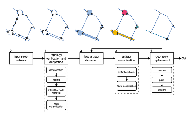
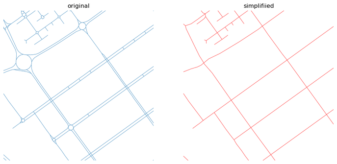
Ever needed to simplify street networks? I did. And it is a pain. So we joined forces with @anavybor and @JamesGaboardi and wrote an algorithm that does that for us. And can do for you, as it is available as a Python package called `neatnet`.

Here's a short blog about it - https://martinfleischmann.net/simplification-of-street-networks/

And here's, not so short preprint - https://arxiv.org/abs/2504.16198

But you probably want the package. That is here - https://uscuni.org/neatnet.

Happy coding!

#python #networks #geopython

Simplification of street networks

I have been working with street networks for a long time. My first analysis will date probably back to 2017 or so. Most of those focused on the same aspect - understanding the morphology. Yet, practically none of the networks I was able to obtain reflected morphology directly. Rather, they captured transportation networks, with all the detailed intersections, every tiny roundabout, slipway, double carriageway, and so on. Which is pretty annoying when you are interested in a representation of space, not of traffic lines.

@panoramax pensez-vous qu'il soit possible d'ajouter l'extension Panoramax pour Lizmap à la partie du site "Ils utilisent Panoramax" ? Est-ce pertinent ?

📢 Nous sommes en train de déployer l'acceptation des CGU, une nécessité légale qui a fait l'objet de plusieurs échanges lors des temps mensuels et sur le forum.

Penser à aller cocher la case en vous reconnectant sur votre instance Panoramax habituelle pour vous permettre de continuer à verser des photos.

Discussion ouverte à ce sujet sur :
https://forum.geocommuns.fr/t/activation-de-la-validation-des-conditions-generales-dutilisation-de-panoramax/2268

Activation de la validation des Conditions générales d'utilisation de Panoramax

Comme on l’avait annoncé durant les temps d’échanges nous venons d’activer la validation des conditions générales d’utilisation sur l’instance de l’IGN. Si vous essayez d’envoyer des photos, vous devriez voir apparaitre une page de validation des conditions avant de pouvoir continuer votre envoi. L’activation de la validation des CGU sur l’instance OSM n’est pas encore effective mais devrait arriver rapidement dans les prochain-es heures/jours. Notez que si des scripts d’imports via l’outil e...

Forum GéoCommuns

Heureux hasard, le script @panoramax pour @3liz_news est la 100e contribution :)

Vous pouvez maintenant visualiser les photos de Panoramax dans Lizmap.

A noter que le script Lizmap pour la nouvelle version du viewer de Panoramax est en cours de finalisation (merci à @PanierAvide pour son aide et sa disponibilité)

Pour le script c'est ici :

https://github.com/3liz/lizmap-javascript-scripts/tree/master/library/api/panoramax

lizmap-javascript-scripts/library/api/panoramax at master · 3liz/lizmap-javascript-scripts

Scripts for Lizmap Web Client . Contribute to 3liz/lizmap-javascript-scripts development by creating an account on GitHub.

GitHub

@panoramax @LizmapForQgis @lizmapforqgis@bird.makeup

Script finalisé et fonctionnel ! Une fois le fork accepté, il sera disponible sur le Github Javascript de Lizmap https://github.com/3liz/lizmap-javascript-scripts

GitHub - 3liz/lizmap-javascript-scripts: Scripts for Lizmap Web Client

Scripts for Lizmap Web Client . Contribute to 3liz/lizmap-javascript-scripts development by creating an account on GitHub.

GitHub

Planning du jour : Finaliser l'extension @panoramax pour @LizmapForQgis @lizmapforqgis@bird.makeup
Un beau programme :)

#panoramax

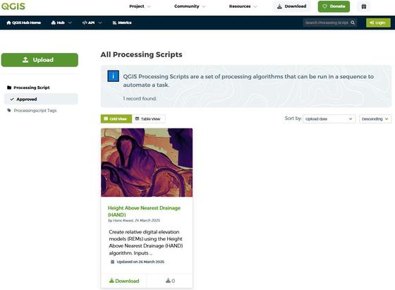
🚀 QGIS Processing Scripts can now be shared via the QGIS Resources Hub! 🎉

They’re efficient, lightweight tools for automating tasks in #QGIS, requiring #Python & #PyQGIS skills. Easier to develop than plugins, they’re perfect for customizing workflows.

💡 Learn more: https://hub.qgis.org/scripts/
💚

Do you want to learn to create your own QGIS Processing Scripts? Check these resources:
🎥 Watch the tutorial video: https://youtu.be/DlKBn7vMT4s

📓 Follow the step-by-step guide: https://courses.gisopencourseware.org/course/section.php?id=376

QGIS Processing Script

Géo Outre-mer de La Réunion : une semaine pour réinventer la cartographie du territoire ! 💡
Face aux défis climatiques et environnementaux, l'IGN transforme la carte en un outil stratégique pour protéger, planifier et agir !

📣 Du 17 au 25 avril, l'IGN organise une semaine d'ateliers et d'échanges à La Réunion pour explorer les données et services publics de l'IGN.

📅 Inscriptions et programme détaillé : https://www.ign.fr/agenda/ateliers-geo-outre-mer-de-la-reunion-une-semaine-pour-reinventer-la-cartographie-du-territoire

Ateliers Géo Outre-mer de La Réunion : une semaine pour réinventer la cartographie du territoire

L’IGN organise une série d’ateliers thématiques du 17 au 25 avril 2025 pour présenter son offre d’appui aux politiques publiques et les dispositifs de collaboration et d’innovation qu’il propose.

| IGN

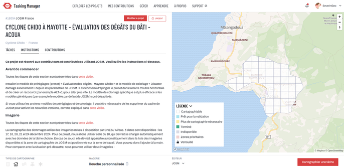
Après Mamoudzou, Tsingoni, Bandraboua et M'Tsamboro, Acoua dans le nord-ouest de Grande-Terre est le nouveau projet @osm_fr@fr.osm.socialproject dans le #taskingmanager pour cartographier dans #josm #openstreetmap les dégâts des bâtiments après le cyclone #chido à #mayotte en utilisant l'imagerie post-catastrophe de @CopernicusEU.

Nous manquons de volontaires, n'hésitez pas à venir apprendre une cartographie différente sur #osm !