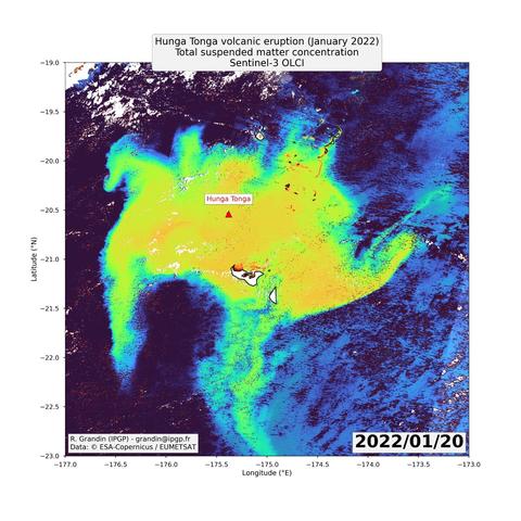
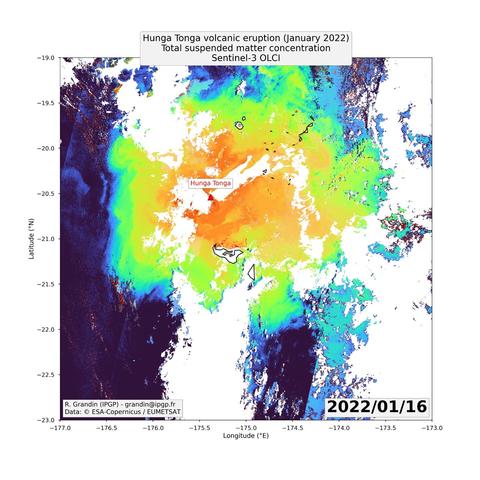
Just a random volcano, seen by a random satellite, in a random false-color composition.


| Website | https://www.ipgp.fr/~grandin/Raphael_Grandin_personal_web_page/Home.html |
| Background image | InSAR image of an earthquake in France |
| Pronouns | He/him |
This #Sentinel3 #satellite 🛰️ image shows the impact of the 15 Jan 2022 Hunga #Tonga #volcano #eruption 🌋 on ocean 🌊 color 🌈 . The image was acquired ~ 24 hours after eruption. Anomaly is here shown in terms of "suspended matter", derived from measurements of the OCLI instrument . It is caused by ash fallouts from the volcanic eruption. In the following days, the anomaly gets dispersed by winds and oceanic currents.
Data: (C) #ESA-#Copernicus / #EUMETSAT

This spectacular image shows the #Shiveluch volcano (Russia) after a recent eruption on Apr 10. #SAR provides a unique opportunity to image the status of the volcano. Experts have looked at our data & noticed a possible new lava dome forming. #volcano
@IPGP_officiel
@GFZ_Potsdam
Source : https://twitter.com/capellaspace/status/1649126815095750656?s=20

“This spectacular image shows the #Shiveluch volcano (Russia) after a recent eruption on Apr 10. #SAR provides a unique opportunity to image the status of the volcano. Experts have looked at our data & noticed a possible new lava dome forming. #volcano @IPGP_officiel @GFZ_Potsdam”
Sulfur dioxide (SO2) plume emitted by #maunaloa #volcano continues to spread above North America.
Images acquired on 02 and 03 Dec 2022.
#Hawaii #Volcano #eruption #lavaflow #maunaloa #lava #Geology #TROPOMI #Copernicus #Sentinel5P #so2 #satellite #remotesensing
Planet imagery captures the ongoing lava flows from #maunaloa #volcano.
Image collected on 01 Dec 2022, at 20:32 UTC.
Left: red-green-blue color composition.
Middle: RTVI color composition.
Right: NDVI color composition.
These color composition rely on the near-infrared spectral bands of the satellite.
Image courtesy of Planet (c) 2022, all rights reserved.
#Hawaii #Volcano #eruption #lavaflow #maunaloa #lava #Geology #Planet #thermal #satellite #radar #remotesensing
Here is the IASI imagery captured on 28 Nov 2022 from Metop-C (around 20:00 UTC).
Estimated plume height reached 16 km (to be confirmed).
Source of #dataviz: VolcPlume portal (c) AERIS / ICARE / LOA.
#Hawaii #Volcano #eruption #lavaflow #maunaloa #lava #Geology #IASI #satellite #remotesensing #SO2 #dataviz
Sulfur dioxide (SO2) RGB composition of the 28 Nov 2022 Mauna Loa (Hawaii) eruption from GOESNG -137° geostationary imagery.
Full animation (MP4) here: https://peertube.virtual-assembly.org/videos/watch/3cc8a340-d2a1-4c91-9a61-e578ce9fdc73
Sampling rate: 1 image every 30 minutes.
Source of animation: VolcPlume portal (c) AERIS / ICARE / LOA.
Data: NOAA / SATMOS.
#Hawaii #Volcano #eruption #lavaflow #maunaloa #lava #Geology #GOES #satellite #remotesensing #SO2 #dataviz