@PamelaSchure asks:

Q7. I saw that willcycle is looking to create tourist biking routes in cities. This might be a great project for those who want to contribute or even those who want to propose a route through their spot. Here’s a link to his post. https://www.willcycle.com/2025/03/25/citycycle/

Do you have a go-to source for cycle routes, as a tourist?

#BikeNiteQ #BikeNite #BikeTooter #Cycling #MastoBikes cc @bikenite

CityCycle - WillCycle

CityCycle routes will be detailed, leisure-cycling, sight-seeing routes for various UK cities, but YOUR help is needed to start building these route guides

WillCycle - Because you deserve some adventure in your life

@PamelaSchure

A7. I haven't traveled to new places much in the last few years 😔

I like the idea of tourist maps with a nice predefined route for sightseeing.

Otherwise I think I'd do some searching to see if a local coalition/person has made some maps showing good routes.

I use Google Maps can't trust them entirely. Usually some street view is needed to make sure the route isn't bonkers crazy.

If I am putting more effort into route planning, I'll make use of heatmaps from Strava, etc, to see which routes are commonly taken.

#BikeNite

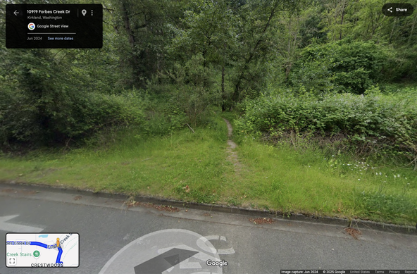
@ascentale @PamelaSchure Google Maps showed me this as a bike route today!

#BikeNite

@moira @ascentale @PamelaSchure

I took a group of 10 people on a camping ride along a path that looked like that a day after a lot of rain.

Remember dragging my fully loaded bike through a giant puddle while a frog stared at me before climbing up a steep gravel hill

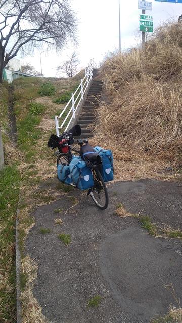
@moira @cainmark @ascentale @PamelaSchure I’ve encountered even sketchier trails.
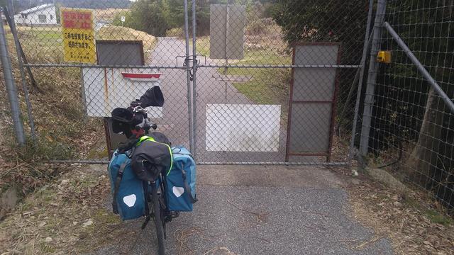
@moira @ascentale @PamelaSchure A couple of little surprises from rides last month.

@ascentale @PamelaSchure @bikenite A7. In the US I think the best bet is to check in advance to see if the area has a cycle coalition. It used to be that many cycle coalitions published or carried paper maps. I just donated a bunch of my old ones to the LA Public Library's Map Room (they welcome cycle map donations as it's a gap in their collection).

https://bikesonom.app.neoncrm.com/np/clients/bikesonom/product.jsp?product=1&

#BikeNite

Sonoma County Bicycle Map

Sonoma County Bicycle Map

Sonoma County Bicycle Coalition

@ascentale @PamelaSchure @bikenite #BikeNite A7. This is great! Local knowledge is great.

I currently look for tourist routes by painstakingly plotting out routes and then checking out Google Street View for bike lanes or clearance, look at how busy those streets are on traffic maps, etc. etc. What I do *NOT* do is use Google Maps because it really chooses bad bicycle routes. I will put routes into OSM and look at the various alternative routes, as well, though.

@ascentale @PamelaSchure @bikenite A7: Seattle being a pretty big tourist town, we have a lot of tourists. Exactly half the Greater Northshore bike shops do rental as a major part of their business, mostly to tourists.

They are the most enthusiastic people so far about my bike maps, and tell me they use them to help direct their tourist customers.

@ascentale @PamelaSchure @bikenite

A7. My best thought about tourist biking routes is to study the Strava heat maps and figure out where people actually go (or really, where they don't ever go). I think I have pretty good instincts to just ride around, but knowing the "avoid this route because it kills cyclists" traps is key.

Riding from park to park can be a lot of fun especially when there are connecting trails.

#BikeTooter #bikenite

@ascentale @PamelaSchure @bikenite

A7. I stop at the local Public Library. If they don't have the information, they can point me to where it will be, if available. Usually a Visitor Center will have paper maps.

Cities, towns, villages--DO NOT discount paper maps and think "everyone has an application program on their phone, anyway." Those don't always work, service isn't always available, and YOU know your place better than any mapping corporation. Use OpenCycleMap.org as a base.

#BikeNite

@cainmark @ascentale @PamelaSchure @bikenite Very much this.

I will say I use a map application that can download maps, Organic Maps in my case (osm based), as digital road map to reinforce the tourist maps which may be limited in some ways spatially.

#BikeNite

@ascentale @PamelaSchure @bikenite
#bikenite A7:
I'd love a more reliable source for cycling routes, but part of the problem is that what one cyclist considers safe, may not be for another.
I mostly use RideWithGPS to start, but use Google Maps satellite view to zoom in to see if a road is paved or not, or has a shoulder. Google Maps street view may help with even more detail.
@ascentale @PamelaSchure @bikenite
#bikenite A7a:
I also use RideWithGPS heat maps to see where the locals ride.

@MartyCormack @ascentale @PamelaSchure @bikenite the safety perception is real.

I picked up some Illinois state "bicycle" maps and it's basically a highway map, minus the interstates, with nearly every route red (unadvised) or orange (exercise caution), and excludes trails. Super intimidating.

Wisconsin's bicycle map focused on conditions like wide, hard shoulders rather than vehicle traffic levels. It had the advantage of making the map look less hostile, and knowing what to expect.

@ascentale @PamelaSchure @bikenite

A7b. I also used Adventure Cycling Association maps for bicycle touring. They were great for 2016, they have digital downloads now (so not necessarily reliant on a service) too.

But local information is always best. Especially for "cut-throughs" or "sneak-ways" a motorists can't use. And bicycle parking. And @meganL created the very useful #CycleParkingAudit

#BikeNite

@cainmark @ascentale @PamelaSchure @bikenite @meganL I joined them for a year or two (about a decade ago) thinking I might tour but also because their monthly magazine was a fund read. Their maps and guides were reportedly really good, but I don't have any first hand experience with them.
Their URL is https://www.adventurecycling.org/
Discover What Awaits | Adventure Cycling Association

Adventure is out there. Find the adventure in your life with our inspiration, resources, and experiences. A bicycle is simply the mechanism to get there.

Adventure Cycling Association

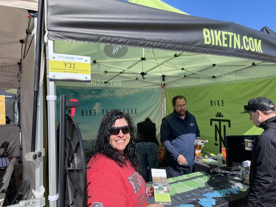
@ascentale @PamelaSchure @bikenite #BikeNite #BikeNite25April2025 #A7 This reminds: We enjoyed meeting Bike Tennessee folks at Sea Otter Classic. Seems they’ve come up with a great tourism initiative for their state, biketn.com.

Here in Monterey County, California helping visitors who bike was one of our first projects, beginning in 2009, hence remains an alternate URL — https://tipsfortourists.com — aka bikemonterey.org. Helping tourists/visitors is mentioned in this 10th anniversary post. https://bikemonterey.org/may-1-10th-anniversary-of-the-bicycling-monterey-site-and-projects.html

In our Bicycle Maps section https://bikemonterey.org/tips-for-tourists/once-you-start, we include links not only to Monterey County’s bilingual (Spanish-English) bike map https://bikemonterey.org/bicycle-map-for-monterey-county.html, but also to some other California bike maps. For more, we encourage checking with other California Bicycle Coalition aka #CalBike Local Partners: https://www.calbike.org/about_us/who_we_are/local_partners/

#BikeTooter #BicycleTouring #EcoTourism #ResponsibleTourism #BikeTouring

| Bicycling Monterey | Resources for Anywhere & Monterey County Biking Information Hub

@ascentale @PamelaSchure A7. as someone who likes to explore on bike when I travel, this sounds fantastic! Usually I ask folks local to the area I’m visiting for resources (including asking here on mastodon!). In places that are a bit intimidating to me, I have also signed up for guided bike tours - San Francisco was one place where even with tons of local advice here, it was really helpful to do a group tour. Available in lots of cities now, often thru LBS. #BikeNite

@ascentale @PamelaSchure @bikenite

A7c. Where I live now is part of the Root River Trail. They were very forward thinking years ago in making this #RailToTrail that connects several small towns. No only does each town have *paper* maps of the Root River and trail and the connected towns, each town has their *own* paper map. Discovered more with those than I did with looking up stuff online.

Legally they are required to be called cities in Minnesota, but they're town sized.

#BikeNite

@ascentale @PamelaSchure @bikenite A7. Intrigued on answers, don't know of much for the US. Would love for this kind of info to make it back to OpenStreetMap for bicycle friendliness somehow. That's kind of my biggest gripe is that bike "routes" aren't always friendly and require a lot of local knowledge to avoid the "officially it's a bike route, but there's no protection and everyone drives 15mph over the 45 mph speed limit" roads.

#BikeNite

@edd @ascentale @PamelaSchure @bikenite I'm working on a Boston bike stress map based on OSM data, trying to get it published in the next couple of weeks. Would love for others to implement my project in other cities.

@scooooooott @edd @ascentale @PamelaSchure @bikenite Does any system codify "usually cleared of ice & snow" into route designations? It's one factor that I can't assess well before setting out in a new direction.

(This bit me in February, when I took a side trip from work to Waltham to pick up something for my partner, looked at OgMaps and thought, "oh, cool, I'll hop on the Mass Central Rail Trail" for a chunk of the way back... only to find it was a glacier.)

@ozdreaming @scooooooott @ascentale @PamelaSchure @bikenite I'm not very knowledgeable on OSM tagging, but I don't think this is tracked in any way remotely close to a "standard". But I also live in a city that rarely sees snow, so there's certainly no bike lane specific policy for clearing it so we'd have no reason to start tagging it.
@ozdreaming @edd @ascentale @PamelaSchure @bikenite I don't think that type of data would be appropriate for OSM, but I could see bike orgs curating that knowledge and/or publishing/sharing condition reports after storms, especially as part of a push for better maintenance
@ozdreaming @edd @ascentale @PamelaSchure @bikenite back when I was commuting on the Minuteman, they did plow regularly, but the timing versus the type of storm could lead to very different results, and often it actually was better the first day or two after a storm then got worse with freeze/thaw cycles creating icy ruts. Really, having a centralized place for condition reports to send and see would be way better in my opinion than noting if a stretch is usually plowed
@scooooooott @ozdreaming @ascentale @PamelaSchure @bikenite I would agree with that. OSM isn't really for dynamic data like that. From a travel point of view, more static path/road maintenance conditions would be nice more often.
@edd @ozdreaming @ascentale @PamelaSchure @bikenite biking doesn't really need traffic reports, but condition reports would be nice sometimes (and way easier to systematically improve that traffic, which kinda would actually be solved by being in a place that cared enough about biking to have bike condition reports)
@scooooooott @ozdreaming @edd @ascentale @PamelaSchure @bikenite there's winter_service tags in OSM and maintenance=salting, but I don't know how widely cycleways are tagged.
https://wiki.openstreetmap.org/wiki/Key:winter_service
Key:winter_service - OpenStreetMap Wiki

@mjr @ozdreaming @edd @ascentale @PamelaSchure @bikenite those look interesting, but yeah, would need a local project to tag enough stuff and maintain those tags to be useful in an area, and still didn't really get to if there are icy patches because the plow came just before the end of all the snow from the storm or there are plowed piles making a mess of intersections, technically cleared but practically dangerous
@scooooooott @ozdreaming @edd @ascentale @PamelaSchure @bikenite yes, it doesn't tell you current status, but it's a start and could help people build a status board or map.
@ascentale @PamelaSchure @bikenite I don't know about tourism specifically, but I really like GeoVelo.app for bike routing. It's based on OSM data, so quality of routing depends also on level of detail the local area has on it's map.
@ascentale @PamelaSchure @bikenite A7 #BikeNite I've no single go-to source, but if it's somewhere new to me I'll usually do a quick web search for vague ideas rather than a route to follow exactly: It's fun to feel you're genuinely exploring. That said, if I'm going somewhere that's home to a 'classic loop' that I've not ridden I will sometimes ride those just to tick 'em off.

@ascentale @PamelaSchure @bikenite A7. https://cycle.travel or local cycling or tourism groups would be my first places

I won't trust @WillCycle because I commented with extra info/corrections about bike-on-train (he says my local has "severe restrictions" - in practice they allow 36+ non-folding bikes per train off-peak), never saw a reply & the misleading info is still up, discouraging cyclists from trains, so I wonder what else on there is off

#BikeNite #BikeTooter #Cycling #MastoBikes

cycle.travel | route-planner and maps - traffic-free & quiet roads

The best-kept secret of a great ride - find scenic routes with fewer cars.

@ascentale @PamelaSchure @bikenite

(in the UK) I use Komoot primarily for off road routes but usually check the places where trails cross roads on street view to see if they're likely to be overgrown. Also useful are the user photos & comments which describe trail conditions

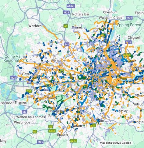
I also use footpathmap.co.uk to check whether the Komoot routes are footpaths or bridleways, and if I'm plotting routes through London I use the safe cycling Google map overlay to find LTNs

https://goo.gl/maps/gU2Fz358Y9c6bFzN6?g_st=ac

Safe cycling in London – Google My Maps

Key: - Thick lines - Protected cycle lanes (segregated from road traffic) - Thin lines - Unprotected cycle lanes (connecting protected sections of cycle track) - Dark Blue - Protected permanent cycle lanes - Light blue - Pop-up cycle lanes (temporary sections of protected cycle lane) - Orange - Shared space with pedestrians - Speed is often limited and there are sections where cyclists must dismount - Green - Shared space routes through parks that are closed at night - Brown - New routes under construction - Pink - New routes in consultation - Blue boxes- Low Traffic Neighbourhoods With support from London Cycling Campaign http://www.lcc.org.uk

Google My Maps

@ascentale @PamelaSchure @bikenite A7. My city's free cycle loan programme, operated by libraries, has downloadable suggested routes in GPX format on the libraries' websites, and the staff encourages the use of Organic Maps.

The routes themselves were put together by various bicycle user groups. Short loops to tourism points of interest, or pretty rides along pleasant routes with plenty of facilities, parks and dining options.

The state government runs a good city-wide cycle route finder. Easily the best router I've used. OSM-based alternatives come second, thanks to a dedicated handful of people making apps route well by fixing the OSM basemap. Google Maps is blah, routing along busy roads for the most part.
https://maps.sa.gov.au/cycleinstead

#BikeNite

@ascentale @PamelaSchure @bikenite A7. RideWithGPS, switching between Google and OSM.
#BikeNite
@ascentale @PamelaSchure @bikenite
Q8: I've never tourist biked!
However, if you're in Ottawa, there's some great resources! An organization called Bike Ottawa has mapping on the website. There are also several bike rental companies, and guided or independent tours available.
Also, the bike community in this city is phenomenal. It's one of the things I like most about Ottawa.
#BikeNite