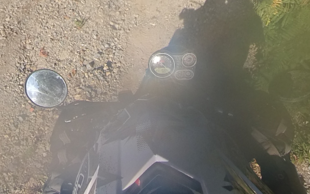
The weather was crap the other day, so instead of being productive, I spent way too much time on a fun challenge #mapping the route of a YouTube #motorcycle travel video.

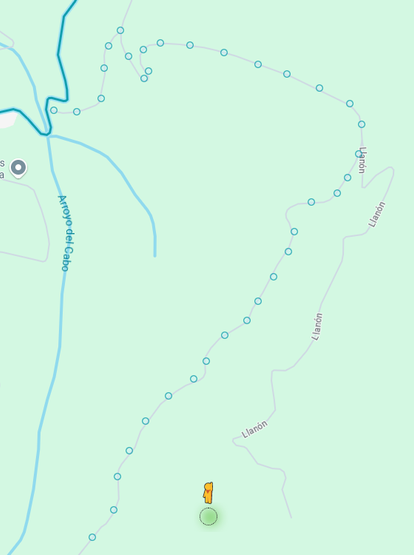
So here is a thread analysing the video and explaining how I mapped the route from clues in the video.

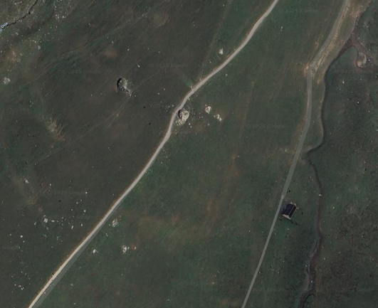
The YouTube algorithm threw an unknown channel video at me, with a great looking thumbnail, so I clicked. The ride indeed was awesome, so I wanted to know where they were riding for future reference.

#geoint #geolocate

The video in question is "Riding the best motorcycle trail in the world" from the #JammyGits channel on YouTube:

https://www.youtube.com/watch?v=Ao3Tt3YP_Mc

I have mapped the route in #Kurviger, a really nice #motorcycle trip planning app:

https://kurv.gr/XrxuH

Mastodon won't let me add the #GPX file directly.

Let me tell you about the mapping by waypoint and timestamp :-)

Riding the BEST Motorcycle Trail in the WORLD - Ep.5

YouTube

Waypoint 0 (Start)
Video: https://youtu.be/Ao3Tt3YP_Mc?t=85

They are leaving a camping named San Pelayo as seen on the sign. That one was easily found on Google Maps. They turn right onto the road.

Riding the BEST Motorcycle Trail in the WORLD - Ep.5

YouTube

Waypoint 1 and 2
Video: https://youtu.be/Ao3Tt3YP_Mc?t=245

Satellite view on Google maps and zooming around a bit quickly leads to the valley with a track through it. Dropping a StreetView pin or two quickly confirms this is the track.

Riding the BEST Motorcycle Trail in the WORLD - Ep.5

YouTube

At this point in the video you can see them riding past a big boulder on the side of the track and you can even easily find that boulder and the barn visible of to the right on the satellite view:

https://youtu.be/Ao3Tt3YP_Mc?t=413

Riding the BEST Motorcycle Trail in the WORLD - Ep.5

YouTube

After waypoint 2 you see them ride through a tunnel.
Video: https://youtu.be/Ao3Tt3YP_Mc?t=496

The StreetView images are from 2012 and the tunnel was not there yet, but on the newer satellite images you can see it covering the road:

https://maps.app.goo.gl/UPU28UQNdYhpX5ey5

Riding the BEST Motorcycle Trail in the WORLD - Ep.5

YouTube

Waypoint 3
Video: https://youtu.be/Ao3Tt3YP_Mc?t=557

They are passing a bridge, the sign says it's the Rio Cares and Camareña is left. That was easily found on Google Maps.

You can't see them make the turn, but they go through a tunnel under some houses, cross back over the river and then the river is on their left and they pass a dam. They're going north for a bit.

Riding the BEST Motorcycle Trail in the WORLD - Ep.5

YouTube

Waypoint 4
Video: https://youtu.be/Ao3Tt3YP_Mc?t=623

This part was hard to locate. They are riding a dirt track on the mountain side. You can see at least 3 or 4 separate power lines running in the valley. And up left in the frame is a barn with 3 red roofs.

Openstreetmap actually shows power lines, so after locating where they run, I had to use Bing Maps, for higher resolution satellite images to locate the red three roofed barn.

https://www.bing.com/maps?osid=163082f7-ea44-48e7-84a9-024c9a563961&cp=43.335488~-4.891664&lvl=16.395279&style=h&pi=0&v=2&sV=2&form=S00027

Riding the BEST Motorcycle Trail in the WORLD - Ep.5

YouTube

Waypoint 5
Video: https://youtu.be/Ao3Tt3YP_Mc?t=668

There is a big jump in location and I let Kurviger plot the route between the waypoints. It may not be completely accurate.

From the video I knew I had to look for a hairpin on a small road with a larger road running parallel to it down in the valley.

Streetview of the hairpin shows the rocks on the right and if you pan around to the street below, you can see it's the same of them riding down again.

https://maps.app.goo.gl/6WPpoU1VNL1pLbF4A

Riding the BEST Motorcycle Trail in the WORLD - Ep.5

YouTube

Waypoint 6
Video: https://youtu.be/Ao3Tt3YP_Mc?t=700

Waypoint 6, riding into Canga de Onis, which they call by name. With the British pronunciation of the Spanish I had to listen at leat 5 times or so to make sense of it.

Riding the BEST Motorcycle Trail in the WORLD - Ep.5

YouTube

Waypoint 7
Video: https://youtu.be/Ao3Tt3YP_Mc?t=818

Waypoint 7, they ride around town for a bit, but when they finally leave, they pass Cafe Bar Lanza, which was easily located. Riding south out of town.

Riding the BEST Motorcycle Trail in the WORLD - Ep.5

YouTube

Waypoint 8 and 9
Video: https://youtu.be/Ao3Tt3YP_Mc?t=828

Next you see them riding on a single track on the side of the mountain. I spent a bit too much time looking at the tracks on the mountain on the eastern side of the road, but after locating waypoint 10, it was easy to plot the track on the map.

Riding the BEST Motorcycle Trail in the WORLD - Ep.5

YouTube

I discovered a few fun tidbits while searching on Google Maps.

When you drag the streetview figure, you can see the mountain track has been mapped by a motorcycle rider with a 360 cam on his helmet. If you check one of his contributions, you can see a sticker on his helmet with a URL that goes to his website: https://www.notanoverlander.com

Front Page

NotAnOverlander

NotAnOverlander

And if you pick the last of the 360 pictures and you pan down and view the cockpit of his motorcycle, you can see he is riding a Royal Enfield Himalyan 411.

https://maps.app.goo.gl/cEtrZZg6u7uKUu9g6

Bevor Sie zu Google Maps weitergehen

Also a nice find, exactly in the spot where they leave the off road track, there is a big old truck parked on the side of the very narrow road. On Streetview this exact same truck is parked on the side of the road.

https://maps.app.goo.gl/z66gsUToJksFsKZ19

Bevor Sie zu Google Maps weitergehen

Waypoint 10
Video: https://youtu.be/Ao3Tt3YP_Mc?t=1113

I actually managed to find this before waypoints 8 and 9 and the single track by looking for a small village with a small, unpaved road leaving the main through road at 90 degrees.

Riding the BEST Motorcycle Trail in the WORLD - Ep.5

YouTube

Waypoint 13 (11 and 12 are only shaping points to keep the route from preferring larger roads)

Video: https://youtu.be/Ao3Tt3YP_Mc?t=1175

They're taking a little breather at a picnic area. Once I figured out that these are called and mapped on #Openstreetmap as "Area recreativa", the correct one was easily located.

Riding the BEST Motorcycle Trail in the WORLD - Ep.5

YouTube

Waypoint 15 and 16 (14 is a shaping point)
Video: https://youtu.be/Ao3Tt3YP_Mc?t=1216

This was pretty hard to locate again. You see them riding up a rocky path, past a barn, with a barren hill in front of them where power lines run. Two power line poles are very close together with a third one further down the hill. The track curves back to the left around the barn. Whew! That was quite a puzzle. Lots of viewing Bing Maps for bare hills and trying to correlate.

Riding the BEST Motorcycle Trail in the WORLD - Ep.5

YouTube

Video: https://youtu.be/Ao3Tt3YP_Mc?t=1264

The part of the video between waypoint 16 and 19, the muddy trail and the rocky track where Martha drops the bike, is the only part I have not been able to locate. The muddy track is quite wet and they are riding into the sun, so it's facing south-southwest. We also know they already booked accomodation that from waypoint 16 is to the southwest. And we pick them up at waypoint 19. That doesn't leave a whole lot of terrain, but really nothing fits the video.

Riding the BEST Motorcycle Trail in the WORLD - Ep.5

YouTube

Waypoint 19
Video: https://youtu.be/Ao3Tt3YP_Mc?t=1405

There is some old farm equipment parked by the side of the road. It's a minor road, but it has a center line. According to the sun this stretch is almost due south. A couple of Streetview pindrops gives us the right location where we can see the same stuff parked along the road.

https://maps.app.goo.gl/Q3PE43kq7FjcYp5GA

Riding the BEST Motorcycle Trail in the WORLD - Ep.5

YouTube

Final waypoint, the destination
Video: https://youtu.be/Ao3Tt3YP_Mc?t=1456

The say they have made it to their AirBnB, they parked the bikes on a small lot. In the last couple of seconds of the video there is a shop in the background on the other side of the street with the name "Almacenas Rafer" which looked like it might be local and sure enough, if you search it on Google Maps, there is only one. So once you know the town they're in, a bit of searching gives you where they parked.

Riding the BEST Motorcycle Trail in the WORLD - Ep.5

YouTube

From the window lettering of the sports bar where they are eating, you can see it's Cafetaria Ramses: https://maps.app.goo.gl/B5t2s88NPSK2UiaeA

And if you search AirBnB for accomodation you can see it's this apartment they stayed at: https://www.airbnb.com/rooms/1208863361800667632

Bevor Sie zu Google Maps weitergehen

So this was a fun little exercise and I learned a few new tricks for planning my own trips.

The main one is: sometimes it is hard to find small and/or dirt tracks, because they can be hard to see on map views.

If you use Streetview of an area, use the little 'map' area on the lower left, expand it, and you will suddenly have a very clear map view showing even the smallest roads very clearly. Not everything can be Streetviewed, but at least you have a lot more info that way.

@fschaap cool exercise and track!

Q: I assume you're familiar with the https://transeurotrail.org/?

Picos de Europa - Sotres Espinama :: Voge 300 Rally

YouTube
@ndantas Too bad it was rainy! That looked absolutely fantastic in the sun 🙂