Bengaluru Central City Corporation has shifted the Town Planning Zone-2 offices from Room 407 (4th Floor) to Room 106 (1st Floor), Annex Building-3, due to space constraints. Citizens are requested to note the new location.


Bengaluru Central City Corporation has shifted the Town Planning Zone-2 offices from Room 407 (4th Floor) to Room 106 (1st Floor), Annex Building-3, due to space constraints. Citizens are requested to note the new location.

Take the “High Line”: the thread about Leith’s unbuilt park through the rooftops
I found something very interesting hidden away in a cardboard file in a corner of Leith Library. The title – City of Edinburgh, Leith Local Plan, Draft Final Report, April 1975. Volume Two. Schedules and Appendices. – was so snappy that I couldn’t help but start reading it. This was the plan for a £90 million redevelopment and rejuvenation of Leith, which by this time was suffering badly from industrial decline, urban depopulation, poor housing stock and a general lack of public amenities. As part of this plan it was proposed that the Edinburgh Corporation as it then was (after 1975 it was Edinburgh District Council) would purchase the abandoned trackbed of the Caledonian Railway which ran from Pilrig Park to Seafield via Restalrig, over Leith Walk and Easter Road. This would be converted into a landscaped walkway through the area, what nowadays we might term a linear park.
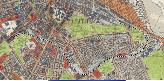
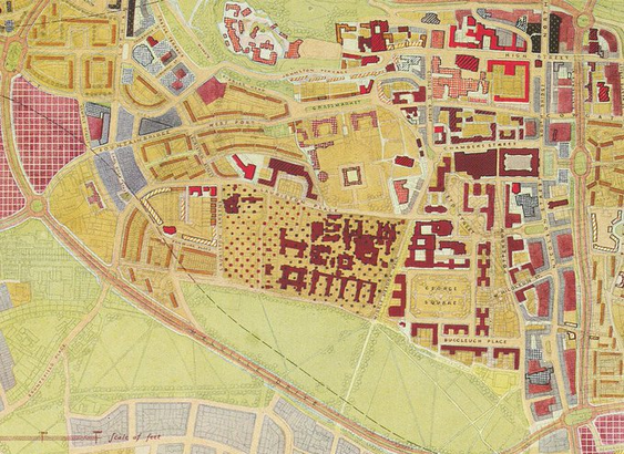
Line of the Pilrig to Seafield section of the Caledonian Railway, traced over a 1971 OS land use survey map on a 6-inch to the mile base map, 1966 survey. CC-by-NC-SA via National Library of ScotlandThis section of railway, formally known as the Leith New Lines, was one of the last to be built in the city and did not open until 1903. Its purpose was to give the Caley access from its existing line into Leith Docks from the west to the expanding eastern portion of the docklands. It would cut its way through the dense industrial heartlands of Leith and Bonnington, serving these with large and convenient new goods stations.
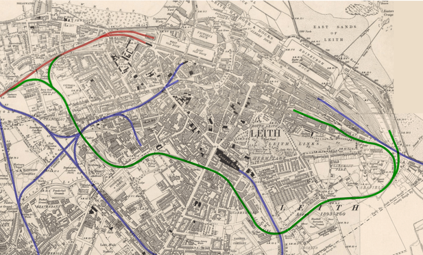
Ordnance Survey 6-inch scale map of Leith, 1906. The North British Railway is highlighted blue, the Caledonian Railway in red and the Leith New Lines in green. Reproduced with the permission of the National Library of ScotlandOn paper this was a sound proposal but by this time the best potential routes through Leith were already well built on, therefore it had to take a winding and circuitous route requiring substantial and expensive engineering. There were numerous cuttings and viaducts required plus skew girder bridges over thoroughfares at Bonnington Toll, Leith Walk and Easter Road. As if that wasn’t enough, it also had to cross three different North British Railway lines, the Water of Leith and cut beneath Ferry Road.
https://www.flickr.com/photos/127340508@N05/40040319893/
This railway never fulfilled its potential, a planned passenger service was never introduced and its twin tracks soon singled. The western section between Newhaven and Bonnington closed in 1965. In 1968 the low bridge over Bonnington Toll was removed and the goods station off Leith Walk at Stead’s Place (Leith Walk West) was closed. For a few years the eastern section at Seafield lingered on giving access to the Leith East goods yard at Salamander Street but this too closed in 1973, making the entire line redundant. British Rail gave notice at this point that it intended to demolish its monumental girder bridges over Leith Walk and Easter Road plus a smaller one over Halmyre Street to reduce their maintenance burden.
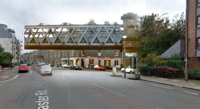
Easter Road #NowAndThen image overlay showing the Caledonian Railway bridge in 1974 and the modern Google Streetview background. Original from Edinphoto. This bridge was removed between January and February 1980.The 1975 path scheme saw the opportunity to purchase the route from British Rail before they proceeded with demolition and proposed to replace these large, expensive structures with lightweight footbridges and to retain the smaller bridge over Halmyre Street. This would give an elevated walkway from Pilrig Park, across the arches of the viaducts at Jane Street, Manderston Street and Gordon Street and from there along the embankments and cuttings all the way to Seafield.
Cover, City of Edinburgh, Leith Local Plan, Draft Final Report, April 1975. Volume Two. Schedules and Appendices.Proposal diagram for the Leith Walk Sawmills and Caley railway yard land off of Pilrig Park.The bridges at Easter Road and Manderston Street would be removed in early 1980, with that over Leith Walk following in September that year.
It have assumed that because the bridge over Halmyre Street was to be retained that the viaduct between there and Easter Road, which cut its way rudely through the back greens between Gordon Street and Thorntree Street would have been kept too.
1929 aerial photo showing the trackbed of the Leith New Lines between Easter Road (bottom right) heading west towards Leith Walk (top left). The large roof to the top right of the photo is Leith Central Station. That building along with the tenements along the line of Manderston and Gordon Streets have since been demolished. The large white roof belongs to the Capitol cinema, until recently a bingo hall. SPW027351 via Britain from Above.This ambitious urban realm scheme of course never came to pass. By the time an updated version of the Final Plan was published in 1980 it had been quietly dropped. One assumes this was because of the disruption caused to local government when the old unitary Corporation of the City of Edinburgh was replaced in 1975 and split up into the two-tier system of Edinburgh District Council and a combined Lothian Regional Council. Instead there was a cut back scheme to purchase the trackbed between Seafield and Easter Road and to landscape it as a pathway with funding from the Scottish Development Agency (SDA). While this at least did come to pass, the word “landscape” is doing a lot of heavy lifting and in reality this path was really just a strip of compressed dirt covered in dog mess and rubbish, with obstructive barriers to try and stop you cycling it without getting off and pushing. This would not be remedied until around 2010 when it was properly surface, the barriers were removed, new access points were added and lighting was provided.
Excerpt from 1980 report.Item 26 on the above list, the railway embankment through Pilrig Park, did also ended up being achieved although the link through to Leith Walk never happened. The viaduct from Pilrig Park to Leith Walk remains fence off, although recent redevelopment on the site of the former Leith Walk West goods yard means there is now a rather roundabout connection some 45 years later through an access road.
Looking along the viaduct above Jane Street towards Leith Walk on a very grey day in 2021. Photo © SelfItem 27, the second walkway which was planned in both 1975 and 1980, along the old North British Railway trackbed alongside the Water of Leith, from Coburg Street to Warriston, would come to pass. This opened in June 1982, making it the first old railway track to formally be converted to a foot and cycle path in Edinburgh, and the first of many more miles to come.
Line of the Coburg Street to Wariston section of the North British Railway, traced over a 1971 OS land use survey map on a 6-inch to the mile base map, 1966 survey. CC-by-NC-SA via National Library of ScotlandThe opportunity to do something between Pilrig Park and Easter Road is one that has never been properly grasped. In more recent times (although over 10 years ago now!) there was a semi-serious attempt to drum up interest in reviving the idea, with a connection between Pilrig Park and Halmyre Street achieved by building a show-piece timber and cable bridge across Leith Walk. How serious this actually was I do not know, I don’t recall any funding ever being in place even for planning, and providing level access to street level at the Thorntree Street end remains a difficult proposition. Even if it had been approved, like other schemes such as the section of Railway between Powderhall and Meadowbank, there’s a very good chance that it would still find itself in development limbo.
Renderings by Biomorphis of their engineered timber and cable bridge structure they proposed over Leith Walk.But if you happen to find yourself walking along past the garages which occupy the Manderston and Gordon Street arches, it’s easy to forget that there’s actually a railway station platform up there above your head, one which was built over 120 years ago but never actually opened. Although some lucky souls in the path have at least had the chance to get off a train there and head down its stairs to street level…
If you have found this site useful, informative or amusing then you can help contribute towards its running costs by supporting me on ko-fi. This includes my commitment to keeping it 100% advert and AI free for all time coming, and in helping to find further unusual stories to bring you by acquiring books and paying for research.
Or please do just share this post on social media or amongst friends and like-minded people, sites like this thrive on being shared.
Explore Threadinburgh by map:
Travelers' Map is loading...These threads © 2017-2026, Andy Arthur.
NO AI TRAINING: Any use of the contents of this website to “train” generative artificial intelligence (AI) technologies to generate text is expressly prohibited. The author reserves all rights to license uses of this work for generative AI training and development of machine learning language models.
#Lochend #Logan #Restalrig #StMargaret
The suburban experiment was designed to skip over the messy process of incrementally assembling a neighborhood. But those steps are necessary, if the neighborhood is to grow strong and endure. Neighborhoods built all at once go bad all at once.
–Escaping the Housing Trap
The thread about a 1949 plan to demolish the Grassmarket and replace it with a “Festival District”
This thread was originally written and published in April 2023.
Today’s surprising newspaper archives find is this 1949 proposal to demolish the Grassmarket and replace it with a Festival District. This (unofficial) plan includes a 3500 seat opera hall, 1500 concert theatre, 700 seat small theatre, two art and exhibition galleries, amphitheatre, a restaurant to seat 2,000 in a single sitting, a school of music and practice rooms, ornamental gardens, a multi-storey car park and so much more!
1949 Grassmarket Festival District proposal, London Illustrated News, 13/8/49. 1 – Car Park; 2 – Restaurant; 3 – Concert Hall; 4 – School of Music; 5 – Gardens; 6 – Opera House; 7 – Ampitheatre; 8 – Small theatre; 9 – Art galleries, exhibition space, admin officesThe proposal was by two “young Scotsmen”; the architect was John Netherby Graham ARIBA and he was assisted by a friend he had made during wartime service, H. A. Rendel Govan MTPI. The two had apparently whiled away their demob time coming up with the scheme after discussing it during the war. They had considered the site of Calton Hill, possibly incorporating the Royal High School (there were plans, even at that stage, to move the school out of Thomas Hamilton’s neoclassical Georgian building). However it was felt to be too exposed a site for the public plaza and amphitheatre they had in mind, so the more sheltered Grassmarket, in the shadow of the Castle Rock was chosen.
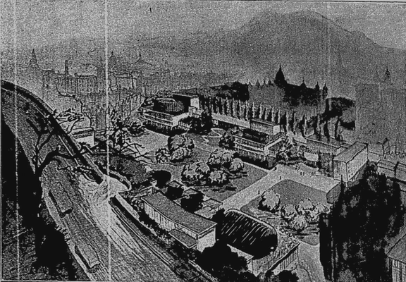
The London Illustrated News article noted that the Corporation and Festival Society had as yet made no direct move towards establishment of such a cultural centre. The Scotsman , reporting on the proposal, noted Edinburgh’s lack of an opera house or theatre with a sufficiently large orchestra pit (for which numerous proposals have come and gone and never been fulfilled), and that the Grassmarket “would not suffer from redevelopment“. It was pointed out that the district showed “limited signs of revival” and that few of the buildings were paritcularly old (most were Victorian rebuilds), and few had any real “architectural quality to warrant preservation.” The artist’s impression for that newspaper shows buildings of a more modern style than those of the London Illustrated News.
Artist’s Impression of the 1949 Festival District proposal from the Scotsman, 1/9/49The scheme put the multistorey carpark at its heart, and envisaged further demolitions to build access roads from Johnston Terrace and Lauriston Place, and the whole plaza of the Grassmarket would form a one-way traffic gyratory around its edge, with the gardens within that ring road. The Castlehill Primary School (now the Scotch Whisky Heritage Centre) was to be demolished to make way for a new foot access corridor up the Mound, up Ramsay Lane and down the other side into the Grassmarket.
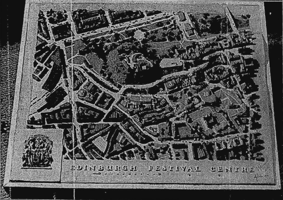
Official looking model of the unofficial Edinburgh Festival Centre, Scotsman 01/08/49The Grassmarket scheme however had gotten ahead of itself, being published before Patrick Abercrombie’s officially commissioned “Civic Survey and Plan” had published its conclusions. This latter plan demolished the Grassmarket too, but zoned it for housing and new schools, instead opting for a split cultural centre, with some facilities grouped around the existing Usher Hall and the Opera House at St. James Square.
Excerpt from Abercrombie Plan for Edinburgh, 1949, centred on Grassmarket, showing school blocks on its south side and new housing and shops on its north.There was also the unanswered question of paying for it all.
In regard to finance it is stated that it is sufficient to assume at this stage that a very large sum would be required in addition to the sum required in respect of compensation for the present buildings and in order to render the undertaking as free as possible from financial worry as large a figures as possible should be aimed at. The total figure would amount to several millions, but in view of the vast repercussions which such an undertaking would have on the life of the city, it might not be unreasonable.
Scotsman. September 1st 1949.After a brief flurry of pro-and-anti letters to the papers, by October 1949 the unofficial plan had run its course and would remain just that: unofficial and a plan. Edinburgh never got its opera house, despite numerous attempts and demolishing sites in anticipation for it. What it did finally get – eventually – was a home for the Traverse Theatre in the corner of a hole demolished for the Opera House in 1966 and left empty for the next 25 years.
Castle Terrace gap site, Royal Lyceum and Usher Hall, Unknown credit, 1989, Photograph © Edinburgh City LibrariesAnd when it did finally get a new cultural venue on this site, the lions share of it was turned over to a new office development to help finance the scheme.
Scottish Financial Centre Model (Saltire Court), Castle Terrace Unknown credit, 1989, Photograph © Edinburgh City LibrariesFootnote, John Netherby Graham, the architect of the 1949 Festival District scheme, is a different John Graham from his contemporary architect who was behind the Harlow New Town in Essex.
Note to readers: unfortunately in April 2026, a third-party plug-in more than exceeded its authority and broke many of the image links on this site. No images were lost but I will have to restore them page-by-page, which may take some time. In the meantime please bear with me while I go about rectifying this issue.
If you have found this site useful, informative or amusing then you can help contribute towards its running costs by supporting me on ko-fi. This includes my commitment to keeping it 100% advert and AI free for all time coming, and in helping to find further unusual stories to bring you by acquiring books and paying for research.
Or please do just share this post on social media or amongst friends and like-minded people, sites like this thrive on being shared.
Explore Threadinburgh by map:
Travelers' Map is loading...These threads © 2017-2026, Andy Arthur.
NO AI TRAINING: Any use of the contents of this website to “train” generative artificial intelligence (AI) technologies to generate text is expressly prohibited. The author reserves all rights to license uses of this work for generative AI training and development of machine learning language models.
#Lochend #Logan #Restalrig #StMargaret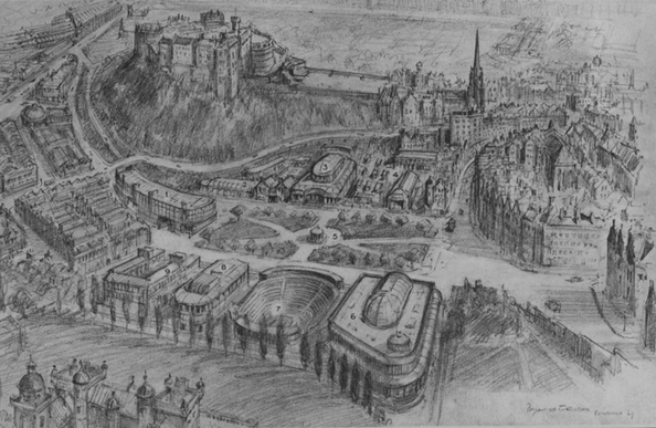
I love it when my it turns out my pipe-dream is already a reality somewhere. Let's ban outdoor advertising.
Driving through a town near where we live, my wife remarks that the layout of a particular junction seems to change every time we go there.
I replied that it was a #Roguelike junction. She did not understand.
One feature of Perth, WA is the 8 kilometres of formerly beautiful riverside from Mill Point in South Perth, south to Mt Henry, that is made obscene by the Kwinana Freeway.
I was living in a caravan park nearby when they got serious about really stuffing that place up.
What folk-memories are out there about how this was allowed to happen?
#Perth #WA #TownPlanning #FolkMemories #FreewayPlanning #WesternAustralia
On where we put our safety efforts

