The specific PR on my mind is an unsolicited contribution to a package from the Urban Institute to fix a minor (but breaking) issue with their exciting new sedtR package https://github.com/UrbanInstitute/sedtR/pull/1

Documentation for the API (part of a book of documentation on the larger project): https://ui-research.github.io/sedt_documentation/api_documentation.html

#RStats #UrbanPlanning #SpatialEquity

Fix installation issue due to missing Remotes for urbnthemes + additional clean-up by elipousson · Pull Request #1 · UrbanInstitute/sedtR

Hope this is a welcome PR! I added urbnthemes to Remotes to avoid an error when attempting installation. I also did some minor clean-up to get everything closer to passing check. Here are the chang...

GitHub

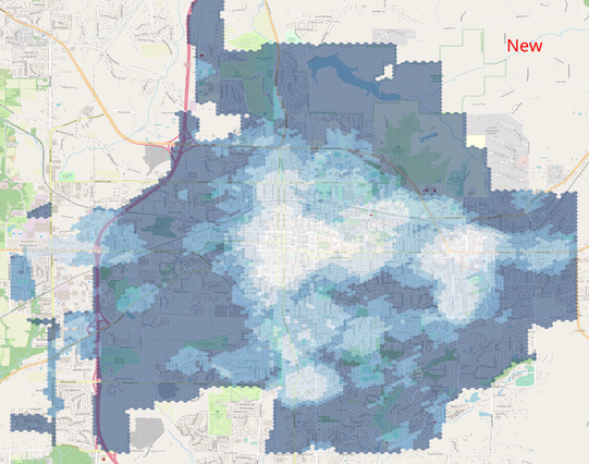
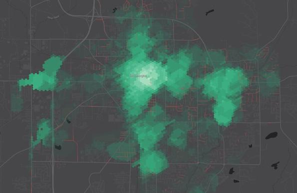
I didn’t know R when I wanted to do spatial analysis. So I used some tools I knew: Turf.js & GeoJSON. For a spatial join, I created a hex grid and created attributes for each cell based on how features intersected.

https://mark.stosberg.com/how-to-create-a-heatmap-sidewalk-location-priority/

#SpatialDataScience #mapping #SpatialEquity #geospatial https://masto.machlis.com/@smach/110831326651730942

How to Create a Heatmap of Sidewalk Location Priority

Your city has an incomplete sidewalk network. The budget to build new sidewalks is limited. Which sidewalks should prioritized to build next in a way that is objective,  transparent and improves transportation equity? Here's how to build to heatmap of locations to prioritize to build sidewalks, based on spatial analysis

Mark Stosberg

Here's a before/after visualization of the updated Walk Potential Calculations for #BloomingtonIN described above. The one labeled "2023" is before. In broad strokes it is similar. It's noticeable how more area around the university scores higher while more areas on the fringes of the city get the darkest color now. Categories were made with Jenks natural breaks.

#UrbanPlanning #SpatialEquity #GIS #mapping

GitHub - plus-mobilitylab/netascore: NetAScore - Network Assessment Score Toolbox for Sustainable Mobility

NetAScore - Network Assessment Score Toolbox for Sustainable Mobility - plus-mobilitylab/netascore

GitHub

The first group believes the system will work for them and has time to advocate for it.

The second group may not believe the system will work for them, and maybe it doesn’t or hasn’t, or doesn’t have time or understanding to advocate for themselves.

Both groups deserve good infrastructure.

#SpatialEquity

I’ve served on a Bike/Ped Commission for years and met neighbors who are good about advocating for better sidewalks in their neighborhoods.

Then I go out and explore the city and find other neighbors have “made the road by walking”. They’ve pounded desire paths into the earth by daily use, yet never showed up to a meeting to complain.

This is why it’s so important that #urbanplanning is based on comprehensive, objective data and not just complaints.

#SpatialEquity #BloomingtonIN

How many mayoral campaign donations are local and which neighborhoods are they from?

Great spatial analysis of campaign finance by @chronicallydave

https://masthead.social/@chronicallydave/109718554164649909

#spatialanalysis #SpatialEquity #gis #localnews

Dave Askins (@[email protected])

https://bsquarebulletin.com/2023/01/19/2023-election-notebook-190k-raised-in-2022-by-bloomington-mayoral-campaigns/ #Elections #CampaignFinance #Bloomington #Grifrin #Thomson #Sandberg #Maps #Charts #Data

Masthead
@sergerey @rsfrankl @geography Congratulations! 🍾 I may have to pick up a copy! I used self-taught spatial analysis to calculate the walk potential of my city and analysis objectively the fairest and most useful locations to fund sidewalks. https://mark.stosberg.com/new-software-to-calculate-walk-potential-for-cities/
#gis #maps #SpatialAnalysis #SpatialEquity
Software to Calculate Walk Potential for Cities

I have open-sourced code to calculate walk potential for cities. Some assembly required. Walk Potential Calculator This code is used to calculate "walk potential" across a city. It's based on the 10 Minute Neighborhood concept of having a neighborhood with having many common types of destinations within walking distance. The

Mark Stosberg
Hello , #datavis #dataart , #mapart, #subjectivemapping, #artistsonmastodon, #art, #designresearch, #spatialequity, #creativethinking, #creativemethods, #slowresearch , #deepmapping, #datafeminism, #participationactionresearch, #dataembroidery, #embroidery, #embroideryart, #socialdesign, #photography, #publicspace, #diarycomics #soesterkwartier lovers. My design research is about this all. I will share my progress with you the coming year. I like to connect and learn. Nice to meet you here.