Sea Levels Rising Dramatically In Some Areas Due To Land Subsidence [global]
--
https://phys.org/news/2026-05-sea-areas-due-subsidence.html <-- shared technical article
--
https://doi.org/10.1038/s41467-026-72293-z <-- shared paper
--
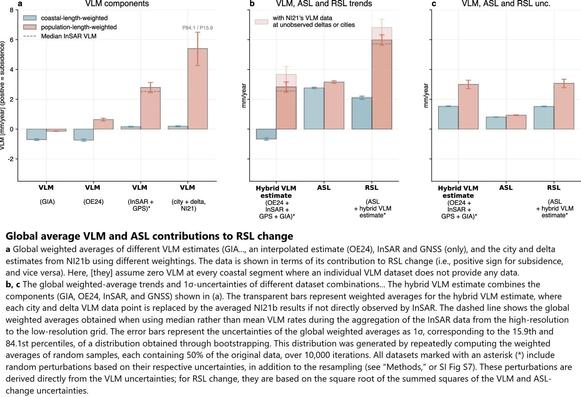
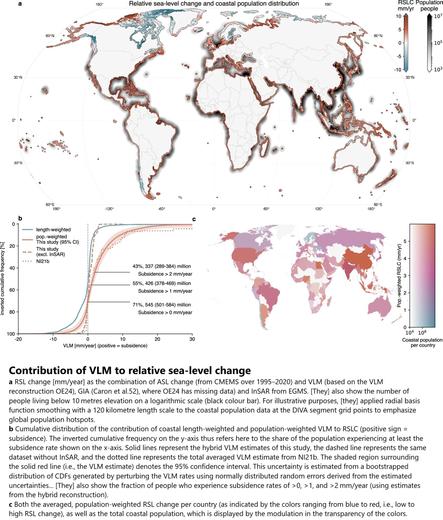
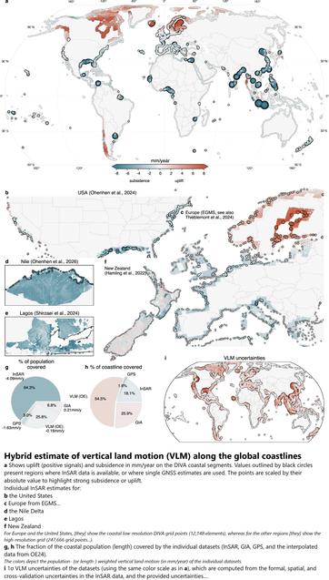
[#VLM = vertical land motion; #ASL = absolute sea-level; #RSL = relative sea-level; #GIA = (global) Glacial Isostatic Adjustment; #inSAR = Interferometric Synthetic Aperture Radar; #GNSS = Global Navigation Satellite System (~GPS); #OE24 = paper, https://doi.org/10.1038/s41561-023-01357-2, interpolated VLM reconstruction based on the joint analysis of GNSS, tide gauges (TGs), and satellite altimetry]
#GIS #spatial #mapping #remotesensing #earthobservation #sealevel #verticallandmotion #absolutesealevel #relativesealevel #GlacialIsostaticAdjustment #geomorphometry #SLR #sealevelrise #coast #coastal #flood #flooding #subsidence #landmass #landsubsidence #global #globalsealevelrise #climatechange #city #urban #farmlands #population #demographics #cities #planning #community #elevation #monitoring #spatialanalysis #spatiotemporal #altimetry
--
https://phys.org/news/2026-05-sea-areas-due-subsidence.html <-- shared technical article
--
https://doi.org/10.1038/s41467-026-72293-z <-- shared paper
--
[#VLM = vertical land motion; #ASL = absolute sea-level; #RSL = relative sea-level; #GIA = (global) Glacial Isostatic Adjustment; #inSAR = Interferometric Synthetic Aperture Radar; #GNSS = Global Navigation Satellite System (~GPS); #OE24 = paper, https://doi.org/10.1038/s41561-023-01357-2, interpolated VLM reconstruction based on the joint analysis of GNSS, tide gauges (TGs), and satellite altimetry]
#GIS #spatial #mapping #remotesensing #earthobservation #sealevel #verticallandmotion #absolutesealevel #relativesealevel #GlacialIsostaticAdjustment #geomorphometry #SLR #sealevelrise #coast #coastal #flood #flooding #subsidence #landmass #landsubsidence #global #globalsealevelrise #climatechange #city #urban #farmlands #population #demographics #cities #planning #community #elevation #monitoring #spatialanalysis #spatiotemporal #altimetry