Kann man mit @everydoor neue Punkte auf bestehenden Ways anlegen? Dann wäre das ja was für die #Openrailwaymap 🤔
#Openstreetmap #fossgis2026
#Openstreetmap #fossgis2026
Dinamarca comienza a sustituir trenes diesel por trenes eléctricos con batería. En la noticia se describen la primera línea con un tramo de 63 km donde están circulando. Me parece muy interesante y con gran aplicación a líneas españolas no electrificadas o a tramos(DA: https://ing.dk/artikel/nu-ruller-der-batteritog-paa-det-statslige-jernbanenet)
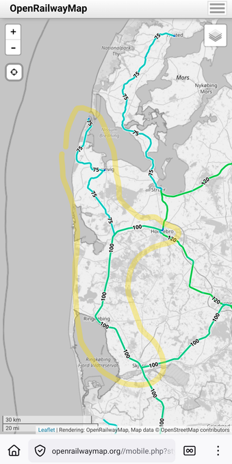
Ls foto es una captura de #OpenRailWayMap (datos de OpenStreetMap)
https://openrailwaymap.org//mobile.php?style=maxspeed&lat=56.14325431233707&lon=8.53912353515625&zoom=9
+Info sobre inicio proyecto y caract. trenes (vmax 140km/h, alcance 80km): EN https://www.railwaypro.com/wp/denmarks-first-battery-train-enters-service/
Denmark's replacing diesel trains. In this piece of news it is described a first line with a track of 67km between chargers. IMO this project, that started last summer, is really interesting and could be adapted to numerous places with partial or no electrification (DA: https://ing.dk/artikel/nu-ruller-der-batteritog-paa-det-statslige-jernbanenet)
The picture is a #OpenRailWayMap screenshot (OpenStreetMap's data)
https://openrailwaymap.org//mobile.php?style=maxspeed&lat=56.14325431233707&lon=8.53912353515625&zoom=9
+Info about the starting of the project and train char.(vmax 140km/h, reach 80km): https://www.railwaypro.com/wp/denmarks-first-battery-train-enters-service/

#DearFedi, does anyone happen to know a website or an app that I could use to easily highlight (as in using color) selected parts of the #railway network (ideally by choosing two stations to get everything in between highlighted), so I could mark which parts of the network I've already traversed, and then share it with you? (needs to include Polish railways)
#DrogieFedi, zna ktoś może stronę / aplikację, w której mógłbym łatwo pozaznaczać kolorkiem wybrane fragmenty linii kolejowych (najlepiej na zasadzie wyboru dwóch stacji, i połączenia ich wzdłuż linii), tak żebym mógł sobie nanieść, które fragmenty sieci już przejechałem, i się następnie tym z wami podzielić?
#DrogiBlipie #kolej #mikol #mapa #OpenStreetMap #OpenRailwayMap
18/ Krass! Höchstgeschwindigkeiten, Signale, Spurweiten, Elektrifizierung, Bahnhöfe
Meine liebsten OpenStreetMap-Angebote
* #Mapy - fast wie Google Maps (mit Kommentare, Routen, Umgebung) https://mapy.com/de/zakladni?source=osm&id=11945282&x=9.9698595&y=53.4611790&z=19
* #uMap - eigene interaktive Karten: super https://umap.openstreetmap.de
* #F4map - 3D is teinfach cool https://demo.f4map.com/#lat=53.5411920&lon=9.9856098&zoom=18
* #MapComplete (POIs) https://mapcomplete.org
* POI-Karte (Filter links!) https://www.flosm.org/de/POI-Karte.html?lat=53.4624300&lon=9.97572439&r=1352.9117
* #Wanderer (Spazieren) https://trails.magdeburg.jetzt/map?lat=53.550341&lon=10.000654&tl_lat=53.796000230890115&tl_lon=10.604031966978994&br_lat=53.28209555774936&br_lon=9.413455372160684
* #OpenRailwayMap https://www.openrailwaymap.org/
#OSM #OpenStreetMap #GoogleMaps -Alternativen

Popular map portal covering whole world by wide range of maps - basic, outdoor (hiking/cycling), traffic, winter. It offers possibility of aerial and 3D view. Extensive amount of travel points of interest. Users are able to search places, plan routes, measure ground and create and share own content. Tourists worldwide use map portal for detailed hiking and cycling maps and extensive tourist guides.

