The thread about Sciennes; how you pronounce it, where the name comes from and its important moment in Scottish literary history

This thread was originally written and published in February 2020.

There was some chat the other week about place names that were so unapparent in their pronunciation that they were the shibboleth of the real local. One which kept coming up for Edinburgh was Sciennes. First things first, it is Sciennes; as in Sheens; as in Machine; as in Rise of the Machines. The name comes directly from St. Catherine of Siena, a convent in her honour being established in the locality in 1517. In Scots, Siena was Seynis or Schiennes. From there it’s a short leap to the modern Sciennes, but the pronunciation has remained true to the original local form.

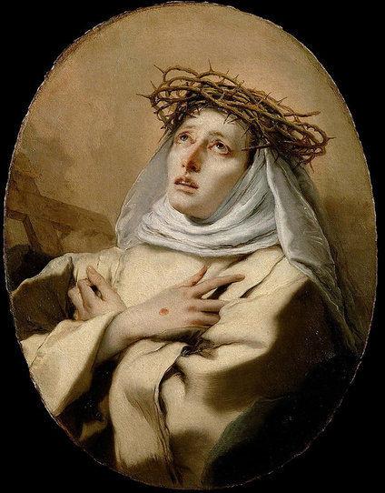
St. Catherine of Siena, by Giovanni Battista Tiepolo

The convent occupied a 2 acre site and was surrounded by an enormous wall, some 13 feet high. The land had been fued off the Burgh Muir (common moor land owned by the city) to the Canon of St. Giles in 1513, who founded a chapel and hermitage to St. John before giving it to the Sisters.

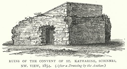
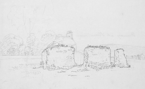
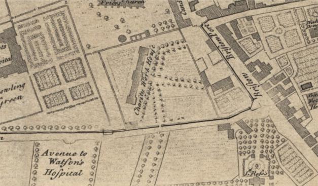
The ruins of Sciennes convent, from Old & New Edinburgh by James Grant. Probably in use as a barn at this time.Another view of the same ruins, looking north east towards Salisbury Crags in the distance. From the Hutton Drawings, vol. 2, CC-BY-SA 4.0 National Library of Scotland

Given the location of the convent some 1,000m outside of the city walls (hence the big defensive enclosure) it is consistently missed off of all the older town plans and it’s not until Kirkwood’s plan of 1817 that it makes an appearance. We can see an old rendition of Scienes and the reference to Siena. The designation as a monastery is a mistake.

Kirkwood’s 1817 Town Plan. Reproduced with the permission of the National Library of Scotland

Notice the 2 arrows in the above map and notice that they correspond to two obvious kinks in the modern street layouts. These mark the turn of the boundary wall of the convent – I have found a good rule of thumbs when looking at old streets in Edinburgh which is that if there is a bend or kink in an otherwise straight road that seems to serve no apparent purpose, there’s a very good chance that it respects the alignment of an even older property boundary. See this thread for instance. Or this one!

Kirkwood’s 1817 Town Plan. Reproduced with the permission of the National Library of Scotland

The presence of the convent also explains why Sciennes Street (marked in green below and now known as just Sciennes) splits off at a very shallow angle from Causewayside (red arrow) . Until the early 19th century one of the two main road south east out of the city – leaving that odd gushet formed by Lord Russell Place; it was the alignment of the original footpath to the convent from St. Giles to the north.

Ainslie’s 1804 Town Plan. Reproduced with the permission of the National Library of Scotland

After the quagmire of the Boroughloch began to be drained in the 18th century and the Meadows began to be laid out as a pleasant, formal park, some of the rich of the city built large villas along the southern edge. A roadway formed at the back of the plots to give coach access, meeting the old route to the convent at its eastern extremity.

Ainslie’s own Plan of 1804, showing the villa plots along the south of the Meadows. Reproduced with the permission of the National Library of Scotland

And at this junction stood a place called Sciennes Hill House. This building isn’t actually on a hill as such, but when entering the city from Causewayside it is at the top of the ascending grade from the south. The Scottish philosopher and historian of the Enlightenment, Professor Adam Ferguson of Raith, lived here at the end of the 18th century. His property was ¾ miles from the city walls at the Bristo Port and so his friends took to jokingly calling it Kamchatka on account of its perceived remoteness.

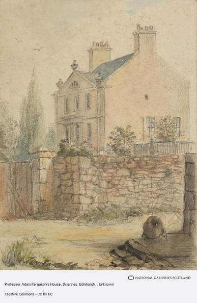
Adam Ferguson in 1781, by Sir Joshua Reynolds.

The National Gallery has the below sketch of the house and notes a soiree which took place there in 1786 that was attended by a young Walter Scott, Robert Burns, Dugald Stewart, Joseph Black, James Hutton and John Home! One can only imagine how inadequate you’d feel, staring into your tea, sitting round a table while that lot had a debate! This was both the first and last time that the young Scott met Burns and it was a formative experience for the former, then just 15 years old.

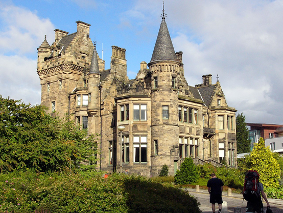
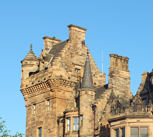
Sciennes Hill House. CC-by-NC National Galleries Scotland

By this time Sciennes was a well-established place name and had given its name to that lane along the back of the big villas, as Sciennes Road, to Sciennes Hill House, to Sciennes House Place and Sciennes Hill Place. And what became of the house itself? Well, believe it or not, it’s actually still there, hiding in plain sight, even if you look straight at it. Its clever disguise is that the back of the house is now the street façade, and the house has been subdivided and reconstructed into what looks from the street to be an unremarkable tenement.

But when you look at it again when armed with the facts, suddenly things begin to look incongruous. That rubble finish doesn’t quite look Victorian, that stair door is out of alignment, and the vertical spacing of the windows is well out with its neighbours.

The rear of Sciennes Hill House is now the front.

Oh and those plaques are a bit of a give away too…

Plaque on Sciennes Hill House. CC-BY-SA 3.0 Kim Traynor

And if you can get around the back, this ain’t your usual finish for a tenement back green! It’s quite obviously the (restored) façade of an altogether different and grander Georgian house.

The original (restored) facade of Sciennes Hill House. CC-BY-SA 2.0 Kim Traynor

The rear of the building was restored in 1989 (there are pictures of it here just prior to this) and given the much quite regular appearance above. In the old engraving below it can be clearly seen where the original doorway and portico was, at 1st floor level, by the gap in the horizontal bands of masonry and window spacing.

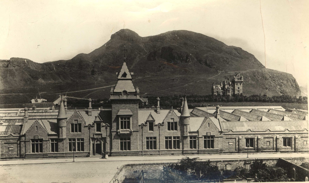
Sciennes Hill House in 1891, from “The Literary Landmarks of Edinburgh”in Harper’s New Monthly Magazine.

St. Catherine of Siena lent her name to one other street in the neighbourhood, that of St. Catherine Place, a street of grand Victorian semi-detached villas on the boundary with The Grange. For some reason though, when Bertrams Ltd. built a large factory in Sciennes, they went for a different spelling and we got the St. Katherine’s Works. Bertrams were ironfounders and engineers, specialising in roller machines for papermaking and printing.

Bertram’s St. Katherine’s Works. Note the malt kiln cupola to the right of the large chimney, from the West Sciennes Distillery. © Edinburgh City Libraries

Bertram’s were a very successful company in their time, with a foundry in Gorgie at Westfield and also one in London – another St. Katherine’s Works – to serve the newspaper industry. Sadly the Sciennes works burned down in 1983 at what was a difficult time for the company, with the Scottish print and papermaking industries in terminal decline. The whole company was gone by 1985 and when new housing was built on the site later it was appropriately named Siena Gardens.

https://www.flickr.com/photos/maleny_steve/42942242202

Sciennes of course also gives its name to the local school (I am typing to you from an old teacher’s desk of that establishment, recovered from a skip). I recall the first time I saw the name, written on an Edinburgh schools football league fixtures sheet about 30-odd years ago and yes I too did imagine it was pronounced Scy-ens.

There’s one more “place” in Sciennes that’s been lost to time, which is the romantic sounding Glen Sciennes. Indeed it’s a place that never even existed anywhere but on paper as a faux-Highland brand name for the spirit from a distillery in the district belonging to Thomas Duncanson & Co. It was being advertised in the London papers in 1854 but the firm went bankrupt in 1859, so Glen Sciennes had a life span of only five years. After this the distillery ran through a number of other names; the Newington Distillery, the West Sciennes Distillery; the Edinburgh Distillery before closing in 1925 by which time it was the last malt distillery in the city. The buildings were incorporated into Bertram’s works.

1850s Post Office Directory entry for the Glen Sciennes distillery.

I don’t know of any contemporary illustrations of the Sciennes distillery, but a William Channing sketch of 1852 of Sciennes Court – where the Sienna Gardens student flats are these days – shows its chimney in the background.

Sciennes Court, 1852 by William Channing © Edinburgh City Libraries

Always be on the lookout for unexplained kinks in old streets or buildings that feel a bit out of place; if you dig into them a little bit you might find out more local history than you bargained for!

Note to readers: unfortunately in April 2026, a third-party plug-in more than exceeded its authority and broke many of the image links on this site. No images were lost but I will have to restore them page-by-page, which may take some time. In the meantime please bear with me while I go about rectifying this issue.

If you have found this site useful, informative or amusing then you can help contribute towards its running costs by supporting me on ko-fi. This includes my commitment to keeping it 100% advert and AI free for all time coming, and in helping to find further unusual stories to bring you by acquiring books and paying for research.
Or please do just share this post on social media or amongst friends and like-minded people, sites like this thrive on being shared.

Explore Threadinburgh by map:

Travelers' Map is loading...
If you see this after your page is loaded completely, leafletJS files are missing.

These threads © 2017-2026, Andy Arthur.

NO AI TRAINING: Any use of the contents of this website to “train” generative artificial intelligence (AI) technologies to generate text is expressly prohibited. The author reserves all rights to license uses of this work for generative AI training and development of machine learning language models.

#Lochend #Logan #Restalrig #StMargaret

The worst school in the world: the thread about St Trinnian’s and its origins in a very different Edinburgh establishment

A Tweet by the National Museums Scotland Library was a timely reminder that cartoonist Ronald Searle took the name for his riotous girls’ school from a real establishment in Edinburgh – but that it not the basis of school itself, which was inspired by two girls schools in Cambridge, where he grew up.

Letter to Miss Frances Kennedy, St. Trinnean’s School, Dalkeith Road

The Edinburgh St. Trinnean’s (note the spelling) was a progressive, liberal school founded at 10 Palmerston Road in Marchmont by headmistress Catherine Fraser Lee in 1922. It was advertised in that;

ST TRINNEAN’S SCHOOL FOR GIRLS
WILL BE OPENED ON OCTOBER 4th AT 10 PALMERSTON ROAD (GRANGE.)

Southern Exposure; Large , Airy Classrooms ; Grounds over One Acre.
Girls from Kindergarten to University Entrance Stage.
Boys up to the age of Nine Years
Prospectus , etc. may be had from the Principal , Miss C . Fraser Lee, MA, Cambridge Teacher Certificate, 9 Cluny Gardens, Edinburgh. Formerly Head Mistress of the County School for Girls, Barry, Wales, and of St. Bride’s School, Edinburgh.

Latest Educational Ideals and Methods.

The Scotsman, July 19th 1922

The Latest Educational Ideals and Methods” referred to the Dalton System of education, which was introduced into Britain by Fraser Lee. It resulted in a school described as being of “few rules and much freedom of thought and action.”

Trinnean is a Gaelic (Manx?) form of Ninian, apparently Miss Fraser Lee was a bit into Celticism. Trynninan is a Northumbrian variant. She gave the school the motto “Solus agus Sonas” – Light and Joy in Gàidhlig.

Ten Palmerston Road had been the home of Horatius (Horace) Bonar, a Free Church minister, popular preacher, poet and hymnwriter, who died there in 1899. Horatius younger brother, Andrew, was also a 19th century Free Church Minister, for whom Andrew Bonar Law was named. Bonar Law holds the dubious record of the shortest serving Prime Minister of the 20th century; his father had also been a Free Church Minister, serving in Canada. (I am indebted to Neil Macleod for this insight.)

In 1925 the school relocated to larger and grander premises off Dalkeith Road at St. Leonard’s Hall, a substantial Scottish Baronial mansion built for the late publisher Thomas Nelson junior next to his Parkside printing works. By this time they were taking boarders, possibly reason behind the move to larger premises with more grounds.

St. Leonard’s Hall, CC-BY-SA 2.0 Christian Bickel

The Parkside Works were built by the same architect (John Lessels) in a similar style, and you can see the manion of St. Leonard’s Hall keeping a watchful eye over it in this photo.

St. Leonard’s in the distance keeps an eye on the Nelson’s Parkside Works

Nelson apparently tired of the opulence and scale of his mansion and preferred to live in a self-contained “cottage” on the top floor of the tower.

The tower of St. Leonards © Ad Meskens / Wikimedia Commons

Thomas Nelson junior left a substantial legacy and one of its public applications was in providing a number of Nelson Halls around the city as a place “to which persons of the working class and others can go to sit, read, write, converse and otherwise occupy themselves“. A Nelson Hall was opened near the Parkside Print Works in 1913, where Bernard Terrace meets St. Leonard’s Street. Others were provided at McDonald Road, Morningside Road and Fountainbridge public libraries.

St. Trinnean’s was evacuated during WW2 and relocated to Gala House in Galashiels in September 1939. It was while Searle was visiting an artists commune in Kirkcudbright that he visited a couple whose daughters attended the school and he drew some cartoons to amuse them. He was apparently impressed that the school’s progressive approach allowed the girls to organise their own studying schedules, and took this to the extreme that they could do whatever they pleased. He took the name of their school, and changed it just enough, but based the riotous pupils on schools near his home in Cambridge.

1940 Post Office Directory entry for St. Trinnean’s School

Searle’s first St. Trinian’s cartoon was published in Lilliput magazine in October 1941, entitled “Owing to the international situation, the match with St Trinian’s has been postponed“.

Searle’s first published St. Trinian’s cartoon. “Owing to the international situation, the match with St. Trinian’s has been postponed”. October 1941.

St. Leonard’s Hall and its grounds were the property of the industrialist John Donald Pollock, who was rector of the University of Edinburgh from 1939-45. The school never returned after the end of the war and was closed by Miss Fraser Lee. Pollock gifted the building and grounds to the University in his will in 1946 and St. Leonard’s became a ladies hall of residence. It is part of the Pollock Halls complex, named for Sir John, but now used as a function / events centre and surrounded by modern buildings, including William Kininmonth’s late 1950s dormitories and refectory and the 1970 Commonwealth Games village.

Pollock Halls complex, CC-BY-SA Richard Webb

In 1998 the former pupils of St. Trinnean’s held their final reunion dinner (appropriately in the Edinburgh University’s Pollock Halls) and “were unanimous in condemning the films and cartoons which immortalised their school as St. Trinian’s and recalled how the school’s founder-headmistress was “broken hearted” at the image portrayed“.

Note to readers: unfortunately in April 2026, a third-party plug-in more than exceeded its authority and broke many of the image links on this site. No images were lost but I will have to restore them page-by-page, which may take some time. In the meantime please bear with me while I go about rectifying this issue.

If you have found this site useful, informative or amusing then you can help contribute towards its running costs by supporting me on ko-fi. This includes my commitment to keeping it 100% advert and AI free for all time coming, and in helping to find further unusual stories to bring you by acquiring books and paying for research.
Or please do just share this post on social media or amongst friends and like-minded people, sites like this thrive on being shared.

Explore Threadinburgh by map:

Travelers' Map is loading...
If you see this after your page is loaded completely, leafletJS files are missing.

These threads © 2017-2026, Andy Arthur.

NO AI TRAINING: Any use of the contents of this website to “train” generative artificial intelligence (AI) technologies to generate text is expressly prohibited. The author reserves all rights to license uses of this work for generative AI training and development of machine learning language models.

#Lochend #Logan #Restalrig #StMargaret

“A hideous and intolerable eyesore”: the thread about the Meadow’s missing Jawbone Arch

The Jawbone Arch from the Meadows was in the news this week, as a local historian (not this one!) found himself ejected from a meeting in the City Chambers for repeatedly pressing a council committee on the subject, the arch having been dismantled over “safety concerns” and “for restoration” almost a decade ago, in 2014.

Jawbone Walk, The Meadows, Edinburgh. Kevin Maclean, 2009. © Edinburgh City Libraries

These bones, a pair of jaws from “arctic whales” are a remnant of the summer 1886 International Exhibition of Industry, Science & Art which was located on a grand, temporary, pavilion in the West Meadows.

The 1886 pavilion of the International Exhibition on the West Meadows, a temporary building believe it or not! Peter Fletcher Riddell bequest to National Galleries Scotland

They formed the frame of a fishing net tent over the exhibit stall that showcased the craft of the Zetland & Fair Isle Knitters. The stall was organised by Katherine Schoor and Barbara Muir, of Schoor & Muir of Lewrick, as an exhibit of “women’s industries” to promote the wares of the traditional Shetland shawl-knitting craft which was suffering in the domestic market on account of imports of Swiss and German products. The wealthy, eccentric and benevolent George MacThomas Thoms, Sheriff of Caithness, Orkney and Shetland, had arranged for six Shetland women to accompany the stall, under the supervision of Mrs Muir.

Stall 1913, the “Zetland & Fair Isle Knitters”. That may be Mrs Muir standing behind the six knitters./ Photo from “Marchmont, Sciennes & the Grange”, Malcolm Cant, 2001

The women came to Edinburgh for a month at a time, before a relief was sent. Three of them came from Fair Isle and produced and exhibited gloves, stockings and caps in hand-dyed local wools. These were based on patterns handed down over generations and taught to their foremothers by shipwreck survivors of the Spanish Armada. It was noted at the time that their gloves matched those still for sale in the market in Valencia. Mrs Muir was joined by 63-year old Elizabeth Mouat, who had gained national fame a few months previous when she found herself abandoned on the Fair Isle mail boat Columbine in a storm that blew her all the way to Norway over 8 days. The vessels crew of three and its other, male, passenger having been separated from it when trying to rescue a man knocked overboard. Betty, a spinner and hand knitter, brought with her the shawl she had worn when on the Columbine.

Elizabeth Mouat alone at sea on the “Columbine”. Illustrated London News, 1886

That stall was one of the talking points of the whole exhibition. The whalebones had been provided by a Mrs Arbuthnott, probably the Hon. Mrs Arbuthnott of Arbuthnott House, Kincardineshire. After the exhibition closed at the end of October, it took over 3 months to dismantle, during which time the West Meadows were closed. In January, Sheriff Thoms wrote to the Town Council to offer up the bones with a view to placing them on the walkway across them when it reopened.

London Illustrated News, 1886 Exhibition, interior of the entrance foyer

Not everyone was happy with this idea. The editor of the Edinburgh Evening Dispatch wrote they were “a quantity of old jawbones, growing mouldy” and had been set up as “a perpetual reminder of the vanity and fleeting nature of human pleasures“. They were “unsightly and gruesome crossbones“. A South Sider replied in support, they were “an eyesore caused by this ungainly structure… a hideous outrage on South Side residenters.”“A. Ratepayer wrote they were “a hideous and intolerable eyesore… gaunt, dirty-coloured decaying relics of a departed Jonah-swallower“. An Astonished One, who had been out of town for some time, had returned to “indignation that such a hideous eyesore should be thus thrust before the residents in [this] part of the city… Is the whole thing a ghastly joke by the council?… It would be more appropriate and much more interesting to erect an archway with the jawbones of the asses who made and supported the proposal“. A. Ratepayer concurred and suggested whichever councillor had accepted them should have “set them up at his own garden gate“.

But the apoplexy of the South Side Green Ink Society wasn’t long lived, and by late September 1887 the jawbones were erected as an arch over the pathway, which the newspapers had already taken to calling Jawbone Walk, a name that has stuck and become official. A metal band around each reads “From Zetland and Fair Isle Knitting Stand, Edinburgh Exhibition, 1886“.

Melville Drive – entrance to ‘Jawbone Walk’. J. R. Hamilton, 1914. © Edinburgh City Libraries

The title of “Jawbone and the Air Rifle” (“a nightmarish folklore tale of a poacher bored by a decades-old marriage who escapes by roaming the local countryside at night hunting prey”) by Mark E. Smith from The Fall was reputedly inspired by him walking beneath them. The jawbones were an ever-present landmark until their removal in 2014, which was only to have been for a year. But experience has told us that Edinburgh’s public monuments, such as sculptures and clocks, have a nasty habit of being officially removed for a short while only to disappear for multiples of years.

Threadinburgh wishes Graeme Cruickshank, whom I have had the chance to meet on a few occasions at the Old Edinburgh Club and can vouch for being a thoroughly lovely man, every success with this bone he has decided to pick with the council and its officers who have taken it upon themselves to decide that there is no local interest or appetite for replacing or restoring the jawbones.

Note to readers: unfortunately in April 2026, a third-party plug-in more than exceeded its authority and broke many of the image links on this site. No images were lost but I will have to restore them page-by-page, which may take some time. In the meantime please bear with me while I go about rectifying this issue.

If you have found this site useful, informative or amusing then you can help contribute towards its running costs by supporting me on ko-fi. This includes my commitment to keeping it 100% advert and AI free for all time coming, and in helping to find further unusual stories to bring you by acquiring books and paying for research.
Or please do just share this post on social media or amongst friends and like-minded people, sites like this thrive on being shared.

Explore Threadinburgh by map:

Travelers' Map is loading...
If you see this after your page is loaded completely, leafletJS files are missing.

These threads © 2017-2026, Andy Arthur.

NO AI TRAINING: Any use of the contents of this website to “train” generative artificial intelligence (AI) technologies to generate text is expressly prohibited. The author reserves all rights to license uses of this work for generative AI training and development of machine learning language models.

#Lochend #Logan #Restalrig #StMargaret
I didn’t know there had been numerous attempts over many decades to get access to Middle Meadow Walk (a broad surfaced tree-lined pathway through the Meadows park, #Edinburgh) for horse carriages and, latterly, motor vehicles. It’s still a very well used green + direct walking + cycling (for over 40 years legally, but probably covertly before) route between #Marchmont - city centre. (Part of me thinks it could have been cool had it included a parkland tram route, though…) https://threadinburgh.scot/2023/07/16/the-thread-about-middle-meadow-walk-how-and-why-it-has-remained-a-traffic-free-route-despite-over-a-century-of-attempts-to-open-it-up/
The thread about Middle Meadow Walk; resisting a century of attempts to “open” it up

Middle Meadow Walk is a very pleasant walk or cycle across the Meadows, and (for walking at least), this has always been the case. But there were concerted attempts to open it to through traffic fo…

Threadinburgh

The thread about Middle Meadow Walk; resisting a century of attempts to “open” it up

Modal filters – closing a road to one form of traffic by a manner such as bollards – are often in the news regards “Low Traffic Neighbourhood” concepts, but are nothing new. By my reckoning, one of the oldest still in force in Edinburgh lies at the top of Middle Meadow Walk where it meets Forrest Road and Teviot Place, and it is one that has resisted attempts to get rid of it for more than a century and a half.

Looking up Middle Meadow Walk in 1914. On the left is the Royal Infirmary, on the right of centre is the Medical School of the University Photograph by J. R. Hamilton in the Edinburgh & Scottish Collection, Edinburgh City Libraries

The Middle Meadow Walk story begins in 1722 when Thomas Hope of Rankeillor took a 57 year lease on the remains of the old Burgh Loch with the purpose of reclaiming the land as an ornamental park. He was bound to provide a tree-lined walkway all around the new park, flanked by a drainage ditch, and a similar walkway across the middle of the park – at this time known simply as the Meadow Walk. In 1737, the Town Council feud a strip across the lands of Heriot’s Hospital to provide a walkway extending the otherwise isolated Meadow Walk up to the roadway outside the town walls near the Charity Workhouse (present day Forrest Road). This was opened to the public in 1743 when the city wall was breached at its head. Maps from the middle of the 18th century reflect these paths and on Edgar’s town plan of 1765 (below) we can see the tree lined avenue. The name Middle Meadow Walk didn’t really come into use until the end of the 19th century to differentiate it from an ever increasing number of formally name pathways across and around the park.

Edgar’s Town Plan of Edinburgh, 1765, showing the tree-lined Middle Meadow Walk at the bottom middle of the frame meeting the hole in the city wall at Lauriston. Reproduced with the permission of the National Library of Scotland

From its very inception Middle Meadow Walk was always just that – a walkway. It was formally re-laid in the early 1850s after a competition was held by the Town Council, won by architect George Smith, for plans to improve and landscape the park as a whole in concert with a final drainage of the eastern portion of the park which had remained persistently boggy despite centuries of attempts to dry it. At this time the head of Middle Meadow Walk at Teviot Place was improved, in connection with the opening up of the new street of Forrest Road. The narrow entrance and lodge cottages on either side of the path were cleared away and four ornamental pillars planned. In the event, only two pillars were paid for by public subscription and these stood unfinished until 1850 when the Town Council paid for the sculptor Alexander Handyside Ritchie to provide a pair of ornamental unicorns to crown them. The wooden posts that formerly prevented (in theory) access to the park by carriage traffic were replaced at this time by more substantial and permanent stone bollards.

Middle Meadow Walk, Forrest Road entrance showing one of the pair of entrance pillars and the stone bollards. Photograph by Thomas Begbie, Glass negative. © Edinburgh City Libraries

In 1864, the proprietors of the feus of the Grange, lead by the feudal superior landowner, Sir John Dick Lauder, 8th Baronet, loudly agitated to have it opened to horses and carriages. A public backlash saw this attempt fail, opinion was very much that this was a move at the expense of the majority to the benefit of a small number of residents who were wealthy enough to have a carriage. Opposition was lead by radical academic John Stuart Blackie. In opposition, Dick Lauder went so far as to write to The Scotsman that the late Lord Cockburn, for whom the Cockburn Association is named, had “express[ed] himself strongly in favour of the Middle Walk being opened as a drive“.

John Stuart Blackie, by Elliott & Fry, Albumen Cabinet Card, 1870s.

Public meetings were held in support of keeping Middle Meadow Walk traffic free, supported by a number of Town Councillors. Dr Begg lent his support – no, not Dr David Begg (now professor), one time city councillor transport convenor – but the Rev. Dr James Begg, Free Chuch minister and social reformer. It was the informed opinion of those against the proposal that “the Provost, Magistrates and Town Council of Edinburgh [were] ex officio the custodiers [sic] and guardians of the Meadows on behalf of their fellow citizens but no more” and therefore had no right to open Middle Meadow Walk to traffic.

The inhabitants of Edinburgh would be all greater geese than any that ever fed upon the common if they allowed the Middle Meadow Walk to be taken from them. If they allowed the proposed schemed to be proceeded with, they would, in his estimation, be greener than any grass that ever grew in the Meadows.

Rev. Dr James Begg, public meeting reported in the Scotsman, 8th March 1864

When it came to the vote, the Town Council came down strongly against the proposal and it remained a footpath. However that didn’t mean drivers didn’t try it on and in 1871 Alexander Moncur, “a young lad”, was knocked down by a horse cab cutting through the Meadows one night.

The North Briton – Wednesday 15 February 1871

Another attempt was made in 1873-4 to drum up support for opening Middle Meadow Walk to traffic, led by the lawyer D. Scott Moncrieff WS. Again the issue divided opinion, again there was a public backlash against it. On Saturday 1st August, a mass public meeting, presided over by Dr John Bowie (a medical doctor of Lauriston Place, who was also a prominent temperance reformer, spiritualist and anti-vivisectionist), was held in the East Meadows in opposition, attended by 1,800 people.

Seeing that the Meadows are the exclusive property of the inhabitants of Edinburgh, as also the Middle Meadow Walk, which has from time immemorial been used as a promenade and quiet retreat for foot passengers, this meeting pledges itself to use every legitimate endeavour to retain intact their rights to the same.

Motion by Mr John Nisbet agreed to by the open air meeting

At a meeting to nominate a town councillor for the George Square ward, prospective candidate Mr Alexander Buncle declared “opening the Middle Meadow Walk was the grossest piece of vandalism that had been proposed during the last 50 years“, receiving loud applause. Once again, to much relief, the proposal failed.

The subject was discussed by the Town Council again in 1876. And 1879. And 1885. And 1892. Unsurprisingly those dates all coincide with someone in favour of the proposal trying to get themselves elected to the Town Council… In 1895 it was proposed to run an extension of the city’s cable tramway down Middle Meadow Walk to Marchmont but once again public opinion came out strongly against the proposal. Instead, the route ended up taking the long way around, down Lauriston Place, via Tollcross and back around Melville Drive. As a result, what could have been a 1 minute journey took closer to 10 minutes (or more when there was congestion at Tollcross). Writing to the Scotsman in 1909, a correspondent calling themselves “One Who Live Beyond the Meadows” said the “walk is a great boon to many living at the South Side, for there are still some who like to walk instead of going in tramcars. Let us… keep this walk free from the noise and rattle of the streets.” To this day, the district of Marchmont remains tantalisingly close to the city centre and yet awkwardly cut off from it by public transport as a result.

Middle Meadow Walk in 1903, from a vintage postcard

Things remained quiet until 1915 and again in 1919 whence once more there was some local agitation in the papers and within the Town Council in favour of the opening of Middle Meadow Walk to traffic – by now motorised. Again there was strong public condemnation.

“For folk that flee in motor cars, And little ken or care”

W. Forbes Gray writing to the Scotsman on the subject in 1919

And yet, despite the incessant attempts to change the status quo, every time public opinion and a majority in the Town Council came down against the “opening” of the route to traffic. Yet still people tried: it was an issue in the 1921-22 local election campaign. An Evening News editorial said in 1921 that it was the “one certain method of setting the heather on fire in George Square ward” and that the suggestion was trouble-making on the part of Leith councillors. And that of 1928. In that year, the Town Council’s Chief Traffic Officer, Mr Roy, had “two pawl posts with red lights” (what we would now call bollards) mounted on the tramway islands on Lauriston Place at the top of Middle Meadow Walk “to prevent motorists assuming that [it] was a traffic thoroughfare”.

In 1931, 1935 and 1936 the issue came up once more. When it looked in 1936 like the Town Council might finally be swayed in favour of the decision, so an effective local “Hands Off!” campaign was mounted by candidates in the George Square ward.

Edinburgh Evening News – Thursday 22 October 1936

Traffic and road safety were big issues at the time. Cllr. Rutherford Fortune said, “there is a clamant (sic) necessity at this time for more play streets for children and it is an extraordinary proposal to suggest the opening to traffic of a place where security is almost absolute.” Citing the example of Melville Drive, which runs through the Meadows East-West, Fortune said “motor cars, noisy motor cycles, bicyclists, motor lorries laden with milk cans, all the roar of a busy street would be let loose beside Scotland’s greatest hospital“. This vigorous defence of the sanctity of Middle Meadow Walk delayed the “Meadows Traffic Plan” until 1939 by which time the war intervened. But change was back on the books in 1946 as part of the University’s Comprehensive Redevelopment Area proposals (which would go on to trash much of the neighbourhood over the following 20 years). As late as 1962, when Forrest Road, Bristo Place and Teviot Place were turned into a one-way gyratory to help “smooth the traffic flow”, the prospect of a straight vehicular route south through the Grange from George IV Bridge was too much for some to resist and noises were made in the papers about it being the time to change.

First day of the Forrest Road / Teviot / Bristo gyratory. A policeman keeps order. Edinburgh Evening News – Monday 13 August 1962

Indeed the *only* change in traffic status for Middle Meadow Walk over the last 170 years came in 1983, after 5 years of campaigning led by Spokes, the Lothian Cycling Campaign, when a painted cycle lane was added to the path. This remains one of the city’s most important cycling routes to this day and has garnered something of a special status in those respects amongst cycling campaigners.

The crowd assembling at the Meadows for a Pedal on Parliament ride. ©Ros Gasson, Photography Scotland via Spokes

The prospect of cycling on MMW provoked Edinburgh’s finest ever green-ink backlash to the Scotsman from Conservative Councillor Ralph Brereton:

“Spokes can get lost and take its commie friends with it. Who wants a proletarian dictatorship anyway?”

Breteton received something of a public slapping down in response and eventually warmed to the idea.

Note to readers: unfortunately in April 2026, a third-party plug-in more than exceeded its authority and broke many of the image links on this site. No images were lost but I will have to restore them page-by-page, which may take some time. In the meantime please bear with me while I go about rectifying this issue.

If you have found this site useful, informative or amusing then you can help contribute towards its running costs by supporting me on ko-fi. This includes my commitment to keeping it 100% advert and AI free for all time coming, and in helping to find further unusual stories to bring you by acquiring books and paying for research.
Or please do just share this post on social media or amongst friends and like-minded people, sites like this thrive on being shared.

Explore Threadinburgh by map:

Travelers' Map is loading...
If you see this after your page is loaded completely, leafletJS files are missing.

These threads © 2017-2026, Andy Arthur.

NO AI TRAINING: Any use of the contents of this website to “train” generative artificial intelligence (AI) technologies to generate text is expressly prohibited. The author reserves all rights to license uses of this work for generative AI training and development of machine learning language models.

#Lochend #Logan #Restalrig #StMargaret
Toast Of Marchmont

Flickr
Castle view 01

Flickr

Heading back from hospital, and thinking that I deserve a pint in Cloisters (after strolling through a very sunny Marchmont).

#Edinburgh #Edimbourg #photography #photographie #architecture #Marchmont