The thread about the Sixth Day of Christmas; the geese of the Guse Dub
This post in the Edinburgh and Leith themed Twelve Days of Christmas is preceded by a thread about “Fiveways” and Goldenacre.
On the six day of Christmas, my true love gave to me; the Guse Dub (a laying), where Guse is the old Scots word for a Goose (see also the Guse Pye or Goose Pie house), and the Dub refers to a pond and spring where geese or ducks were once kept. Guse Dub was a common Scots term for a farm or village duck pond. If you are interested in golf, you may know it as a the name of the 14th hole of the Prestwick course, which at one time was alongside an old pond.
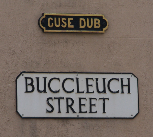
The Guse Dub reproduction historic place name sign CC-by-NC Leo ReynoldsBut in the context of Edinburgh, this place name has long been applied to a little gushet* of the Southside, where the Crosscauseway meets Causewayside (* = Gushet is the Scots term for a triangular portion of land). The dub itself, described as “rather an unsavoury pond” was sold by the city in 1681 to one John Gairns, who built a house hear called Gairnshall and is first directly referred to in 1698 when the then proprietor of the house and land wanted to be freed from his feudal obligation of watching and warding (i.e. enforcing the law) of the district.
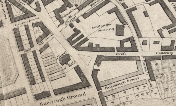
Kincaid’s town plan of 1784, showing the location of the Guse Dub in the triangle of land at the western end of Crosscauseway, where it meets Causewayside, now Buccleuch Street. Reproduced with the permission of the National Library of ScotlandThe pond itself was recognised as a health hazard and drained around 1715 (in connection with the draining of the nearby Boroughloch for the same reasons) and turned into gardens. It originally drained naturally east, towards St. Leonards, and then down through Holyrood Park towards the Canongate, where it joined the East Foul Burn.
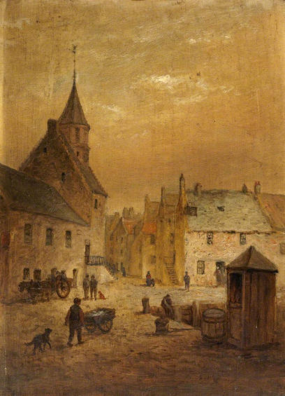
“Cross Causeway and Buccleuch Church, Edinburgh”, William Smeall, c. 1820s. The artist is looking up Chapel Street, the Guse Dub is on the right, behind the wooden shack and barrel. Museums & Galleries Edinburgh – City of Edinburgh CouncilA house of this name once stood here, on 2 acres of ground, which was also known as the Yardhall. In 1786, an avert in the Caledonian Mercury lists a shop and house for sale in this area, described as being “on part of the lands of Goosedub and Yardhall, lying on the east side of the street, leading from Bristo Street and Chapel of Ease to the Sciennes”. In 1788, there is an insurance record for Peter Stewart, described as a baker in the “Goose Dub, near Edinburgh“. From 1805, William Brown, blacksmith, is listed as resident here in the city’s postal directory. He is joined in 1809 by James Reid, a grocer. In 1815, a Mr McCrea, resident in the Goose Dub, subscribed one pound to the city’s Waterloo Patriotic Fund. Brown is still listed under Goose Dub in 1822, at which point the place name disappears from the directories.
Looking towards the Guse Dub along West Crosscauseway, an 1830 sketch by Walter Geikie. © Edinburgh City LibrariesWalter Scott refers to the place in his Waverley Novels, where a Scot in London attempts to argue that Edinburgh is indeed a riverine city:
“The Thames!” exclaimed Richie, in a tone of ineffable contempt- “God bless your honour’s judgement, we have at Edinburgh the Water-of-Leith and the Nor-loch!”
“And the Pow-Burn, and the Quarry-holes, and the Guse-dub, fause loon!” answered Master George, speaking Scotch with such a strong and natural emphasis.
Since the pond was drained, the Guse Dub has been a bit of a neglected wedge of open space that can’t seem to find a purpose. For many years it was the site of a drinking fountain and horse trough, but since the city turned itself over to motorcars it has been little more than a forlorn tarmac island-cum-carpark. The Causey Development Trust have been trying for a long time to improve this situation, they’ve more on their project and the history of the Guse Dub here;
The Guse Dub in 1912, a photograph by J. C. McKenzie of the Edinburgh Photographic Society. A horse drinks from the trough in its centre. © Edinburgh City LibrariesIt is probable that Scott’s decision to list it that kept the place name in the popular imagination after this, and left a well known record of it that was rehabilitated in more recent times when the traditional place name signs were put around the city.
Goose, Patrizio Belcampo. © the artist. Image credit: NHS Lothian Charity – Tonic CollectionThe Edinburgh and Leith Twelve Days of Christmas thread continues with a post about Swanston and the Swan Spring.
Note to readers: unfortunately in April 2026, a third-party plug-in more than exceeded its authority and broke many of the image links on this site. No images were lost but I will have to restore them page-by-page, which may take some time. In the meantime please bear with me while I go about rectifying this issue.
If you have found this site useful, informative or amusing then you can help contribute towards its running costs by supporting me on ko-fi. This includes my commitment to keeping it 100% advert and AI free for all time coming, and in helping to find further unusual stories to bring you by acquiring books and paying for research.
Or please do just share this post on social media or amongst friends and like-minded people, sites like this thrive on being shared.
Explore Threadinburgh by map:
Travelers' Map is loading...If you see this after your page is loaded completely, leafletJS files are missing.
These threads © 2017-2026, Andy Arthur.
NO AI TRAINING: Any use of the contents of this website to “train” generative artificial intelligence (AI) technologies to generate text is expressly prohibited. The author reserves all rights to license uses of this work for generative AI training and development of machine learning language models.
#Lochend #Logan #Restalrig #StMargaret