Derive Urban Footprint with QGIS
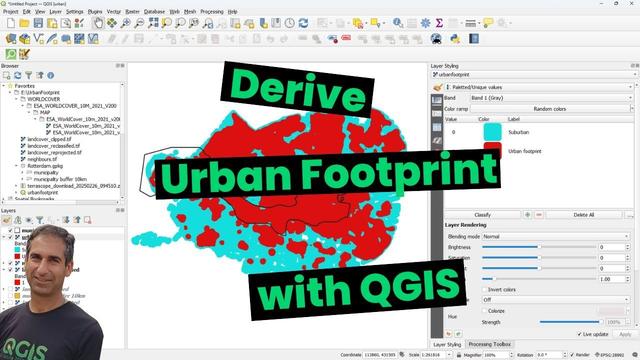
Derive Urban Footprint with QGIS

 https://youtu.be/mlvtHdZsMZo
Now, users can access Global Landcover V2 using an openEO instance in CDSE
A notebook that uses this collection to calculate time series profiles and statistics for European administrative areas and specific land cover or ecosystems relevant to biodiversity is available in this link: https://github.com/eea/clms-hrvpp-tools-python/blob/main/HRVPP_biodiversity_with_OpenEO/HRVPP_openEO_biodiversity.ipynb

Newsletter time! Today we discuss:
🌋monitoring lava lake #volcanoes from space
🗺️ESA's new #WorldCover map
🥵record low sea ice in #Antarctica
🗑️@VITO and #WasteWatchers cleaning rivers
📆and tons of #EOjobs and #EOevents!
Go check it out in the following languages:
🇬🇧https://mailchi.mp/4efb0104f57c/beo-15700272
🇳🇱https://mailchi.mp/ef92435b000c/beo-15700424
🇫🇷https://mailchi.mp/20ec6c2459e7/beo-15700432
#30DayMapChallenge Day 11: Red
Made an interactive web #map (app?) to visualize built-up/built area pixels (in red) in #Esri #landcover, #ESA #WorldCover, & #Google #WorldResourcesInstitute #DynamicWorld.
Link to app: https://tirthankar25.users.earthengine.app/view/built-compare
Earlier this year, we published a paper comparing all land cover classes (not just built-up) in these three datasets: https://doi.org/10.3390/rs14164101
RT @VITO_RS_: 🥳 One year after the release of the first 10m global #landcover map based on #S1 & #S2, #WorldCover is proud to release #WorldCover2021.
@RubenVDKerchove explains more about this new map, algorithm and #Sentinel composites! 🛰️🌍💚
@ESA_EO @CopernicusEU
https://blog.vito.be/remotesensing/worldcover2021
🐦🔗: https://nitter.eu/CopernicusEU/status/1586250200808423424
RT @BelgianEO: Mark your calendars for @ESA_EO's webinar on the release of #WorldCover 2021! The new and improved global land cover map at 10m resolution. No registration required!
🗓️when: Friday 28 October (15:00 - 16:00)
➡️more: https://eo.belspo.be/en/agenda/webinar-release-worldcover-2021
🐦🔗: https://nitter.eu/CopernicusEU/status/1584454806042660864
In October last year, the WorldCover consortium released the first global land cover map at 10 m resolution for 2020 based on both Sentinel-1 and Sentinel-2 data commissioned by the European Space Agency (ESA). Following the positive feedback from the users, ESA decided to extend the WorldCover project and requested the WorldCover consortium to produce a 2021 version of the product with even higher quality. This new and improved WorldCover map for 2021 will be released on October 28, 2022.
RT @Terrascope_BE: Great news! 🙌
Upon request of @ESA the #WorldCover consortium will develop an updated global #landcover map at 10 m resolution for 2021
DYK that the #WorldCover map is also available in our #Terrascope #EO viewer? 🛰️🌍🤗
@BelgianEO @ESA_BE @CopernicusEU @earsc @dennisclarijs
🐦🔗: https://nitter.eu/CopernicusEU/status/1527709759381868546
