https://en.wikipedia.org/wiki/Gladys_West
"Before GPS became an everyday utility, it was a hard mathematical problem.
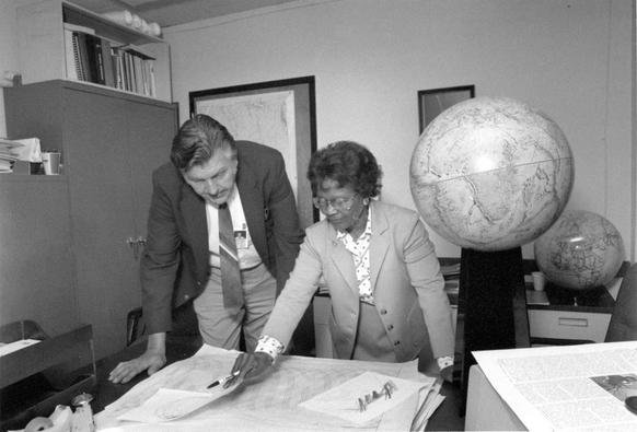
In 1950s–70s, Gladys West - mathematician @ U.S. Naval Surface Warfare Center in Dahlgren, VA - worked on one of the most difficult challenges in satellite navigation: accurately modeling the Earth itself.
Modern GPS accuracy depends on:
• Precise satellite ephemerides
• Accurate gravitational field modeling
• Correct Earth reference frames
West’s work directly advanced all three
Her contributions weren’t widely recognized; it wasn’t until 2018 that she was inducted into the USAF Space and Missile Pioneers Hall of Fame - decades after GPS reshaped global navigation, logistics, finance, defense & mobile computing...
Before GPS could tell us where we are, someone had to define what the Earth actually looks like mathematically…”
#Engineering #GPS #Geodesy #STEM #TechHistory #WomenInTech #DataScience #Infrastructure #WomenInGeoSpatial
H/T Evan Kirstel [despite their puerile AI-generated image of Ms. West]
You should also watch the closing session of #FOSS4G2022. It was an amazing #FOSS4G conference.
Sandro Santilli received the Sol Katz Award 2022.
https://youtu.be/x6W_SLAcW9k?si=H-ouas3pHnslyN8L
It was Letwin Pondos first FOSS4G. She is from Zimbabwe and is sharing her experiences #youthmappers #WomeninGeospatial #SheSpeaksSpatial
https://africansurveyors.net/she-speaks-spatial-2/ #osgeo #fossgis
- YouTube

Enjoy the videos and music you love, upload original content, and share it all with friends, family, and the world on YouTube.

Panel on Making money with free software, Alex Leith facilitating, with panelists Anne Harper, Amir Farhand, Nyall Dawson, Renee Manser.

Questions:
- Have you or your organisation ever contributed time or money to an open source project?
- I build QGIS plugins for clients for money. How can I convince them to make them public?
- What are your favourite examples of good actors building businesses around open source?
+ more!

#FOSS4GOceania2023 #WomenInGeospatial

Elisa Puccion facilitating the Panel: Building Community - how to start and maintain a healthy and engaged community.

Questions:
- Why is this community more fun than the ESRI community
- Characteristics of a 'healthy and engaged community'
- Is making money in and around OS communities a good or bad thing?
- Key aspects for maintaining a thriving community?
- #FOSS4G can be fragmented. What can we do to focus our efforts to have bigger positive impact.

#FOSS4GOceania2023 #WomenInGeospatial

Day 3 of FOSS4G SotM Oceania!

Carrol Chan presenting the first keynote today - Do you see what I see? Building = yes and other defaults.

On why we should care about diversity and data in the Pacific, and the role of local mapping communities.

#FOSS4GOceania2023 #WomenInGeospatial #OpenStreetMap #PassTheMap

Lanieta Rokotuiwakaya and Arnalie Vicario presenting: Do you know about the… OpenStreetMap Foundation?

Join the OSM Foundation, and help support OSM!
https://osmfoundation.org/wiki/Main_Page/
https://supporting.openstreetmap.org/

#FOSS4GOceania2023 #WomenInGeospatial #SupportOSM @openstreetmap

PhD student Maria Kottermair talking about Mapping reef islands in 3D.

Very cool study using #LiDAR field surveys and #StructureFromMotion methods, 3D shoreline change is a step up from traditional 2D mapping!

#FOSS4GOceania2023 #WomenInGeospatial

GeochicasOSM and SpaceSyntaKS take Firenze

Aug 23, 2022, 7:00:00 PM - GMT+2 - Le Murate, 50121, Florencia, Italia - Everyone is welcome to join us to meet other women and allies attending FOSS4G Firenze who are interested in closing the gender gap and working towards diversity in our communities. We want to meet you…

Geochicas and Women+ in Geospatial take Firenze

https://mobilizon.it/events/dc5b1478-b9f8-4f53-bd00-4476605e6d94

Geochicas and Women+ in Geospatial take Firenze

Aug 23, 2022, 7:00:00 PM - GMT+2 - Le Murate, 50121, Florencia, Italia - Everyone is welcome to join us to meet other women and allies attending FOSS4G Firenze who are interested in closing the gender gap and working towards diversity in our communities. We want to meet you…

RT @[email protected]

Day 7: Red
More monochrome! All 14443 GPS points are a semi-transparent bird footprint belonging to one of 28 individual birds. The Red-backed shrike is also a Red List bird meaning the population is in severe decline and globally threatened #30DayMapChallenge #WomenInGeospatial

🐦🔗: https://twitter.com/AllisonCully/status/1192522406927060992

Allison Cully on Twitter

“Day 7: Red More monochrome! All 14443 GPS points are a semi-transparent bird footprint belonging to one of 28 individual birds. The Red-backed shrike is also a Red List bird meaning the population is in severe decline and globally threatened #30DayMapChallenge #WomenInGeospatial”

Twitter