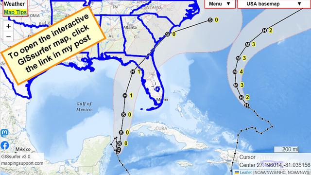
Each time you open this interactive #GIS map for soon-to-be #HurricaneIdalia you will see the latest forecast. The water in the gulf is warmer than normal so it is possible this will be stronger than category 1 at landfall.

“Map tips” link upper left corner has more info.
#Idalia #TD10 #Hurricane #FLwx #GAwx

Open GISsurfer map:
https://mappingsupport.com/p2/gissurfer.php?center=27.196014,-81.035156&zoom=5&basemap=USA_basemap&overlay=Forecast_error_cone,State_boundary,Hurricane/Storm_observed_track,Hurricane/Storm_observed_position,Hurricane/Storm_forecast_track,Hurricane/Storm_forecast_position&data=https://mappingsupport.com/p2/special_maps/disaster/USA_weather.txt

GISsurfer General Purpose Web Map and GIS Viewer | Surf GIS DATA

GISsurfer lets you surf a nearly endless amount of GIS data. Click a layer in the GIS server's table of contents and that data appears on the map.

#TD10's low level center peaking out on satellite. Still has some organizing to do but it has time while sitting over warm water. Tropical systems like to be nicely organized with the low level center (LLC) under / surrounded by storms. 10aCDT/11aEDT 27Aug2023
#Hurricane Hunters flying through #TD10 today. This will help to determine strength and the approx. center. This info will aid with track projections. The cone WILL continue to shift. Just because you are not in the cone does not mean you should not be prepared. #wx #flwx #Idalia
#TD10 still sitting near Cancun, Mexico. Watches for the US mainland likely coming later today (time based issued - 48 hours prior to wind start arrival). NHC has 90mph near FL coast, but can't rule out rapid intensification & stronger storm. Please be prepared! 27Aug2023 #FLwx

Doggos have been out to check for blighters and weather. No blighters to report #ZSHQ however #PalsPorch #HHH likely. #FUGLY possible.

#TD10 brides and menaces Gulf of Mexico. Plotting Wednesday/Thursday nor’easter exit stage East. With rain, flooding and TS tornados possible.

Better info Monday midday and Tuesday.

@ai6yr Promoting to #TD10
Note. This week there will be many models telling different strengths/paths of #TD10. Uncertainty remains. We know the Gulf can rapidly intensify storms. We saw this with Michael, Laura, Harvey, etc. No matter the outcome #Florida should be prepared for any outcome. #flwx #Idalia
@theeyewallwx Promoting to #TD10