Il Tempo: Derby alla Roma: bis di Mancini stende la Lazio e la Champions è più vicina

La Roma dei Friedkin non è mai stata così vicina alla Champions. La squadra di Gasperini batte 2-0 la Lazio nel derby di mezzogiorno con una doppietta di Mancini e sale al quarto posto in solitaria, sfruttando il ko casalingo della Juventus contro la Fiorentina. Una stracittadina inedita, giocata dalla Lazio senza i propri tifosi (radunati a Ponte Milvio per protesta contro la proprietà) e con il terzo portiere Furlanetto, per via degli infortuni di Provedel e Motta. L'estremo difensore biancoceleste – all'esordio in Serie A – è l'unico che fa bella figura tra le file biancocelesti, scaldando subito i guantoni con un intervento centrale sul tiro di Wesley. Nei primi quaranta minuti la formazione di Sarri è brava a sporcare le linee di passaggio giallorosse, sfruttando le difficoltà dei romanisti nella scalata sulla catena formata da Nuno Tavares e Noslin. L'occasione più nitida per la Lazio nel primo tempo ce l'ha però Gila che svetta a centro area di testa sugli sviluppi di un calcio d'angolo e colpisce a lato.
Uno spavento grosso per la Roma che perde Ndicka per un problema muscolare, costringendo Gasperini a ridisegnare la difesa con Rensch a tutta fascia a destra, Celik braccetto e Mancini perno del terzetto. È proprio il centrale azzurro a sbloccare il risultato al 40' con la specialità della casa, il colpo di testa, sugli sviluppi di un corner. All'intervallo Gasperini richiama in panchina Pisilli, inserendo El Shaarawy, alla sua ultima partita con la Roma in casa prima dell'addio in scadenza. Il copione della partita non cambia. Entrambe le squadre sbagliano tanto dal punto di vista tecnico, con qualche lampo improvviso. Al 63' si accende Malen che con una girata di prima intenzione impegna Furlanetto, che si ripete su un calcio di punizione di Dybala. Sul calcio d'angolo successivo però la Roma raddoppia e lo fa sempre con Mancini che di testa è una sentenza e realizza il quarto gol stagionale. Il finale si accende con un rosso all'indirizzo di Wesley e Rovella a seguito di una rissa. Nel recupero è Furlanetto ad evitare il 3-0 con una gran parata su un tiro di Soule'. Cambia poco. La Roma è quarta e a Verona dovrà difendere il piazzamento Champions. La Lazio è nona e chiuderà contro il Pisa una stagione fallimentare.

Roma Derby: Mancini’s two-goal win stuns Lazio and Champions League is closer.

The Friedkin Roma has never been so close to the Champions League. Gasperini’s team beat Lazio 2-0 in the midday derby with a double from Mancini, climbing to fourth place alone, taking advantage of Juventus’ home defeat against Fiorentina. An unprecedented derby, played by Lazio without its own fans (gathered at Ponte Milvio to protest against the ownership) and with third-choice goalkeeper Furlanetto, due to the injuries of Provedel and Motta. The Lazio goalkeeper – making his debut in Serie A – is the only one who looks good in the Biancocelesti ranks, immediately warming up his gloves with a central intervention on Wesley’s shot. In the first forty minutes, Sarri’s formation is good at smearing the giallorossi’s passing lines, exploiting the Romans’ difficulties in ascending the chain formed by Nuno Tavares and Noslin. However, Lazio’s clearest chance in the first half came from Gila, who rises in the center area with a header on the development of a corner kick and hits wide.

A big scare for Roma, who loses Ndicka for a muscle problem, forcing Gasperini to redesign the defense with Rensch at full right, Celik in the center and Mancini as the cornerstone of the trio. It is the Azzurro center back who unlocks the result at 40’ with the home specialty, a header, on the development of a corner. At halftime, Gasperini recalls Pisilli to the bench, inserting El Shaarawy, for his last game with Roma at home before his expiring farewell. The script of the game doesn’t change. Both teams make a lot of technical mistakes, with a few sudden flashes. At 63’, Malen lights up with a purposeful spin that challenges Furlanetto, who repeats on a Dybala free kick. However, on the subsequent corner kick, Roma doubles the score, always with Mancini who, with a header, is a sentence and scores his fourth goal of the season. The end ignites with a red card for Wesley and Rovella following a brawl. In added time, Furlanetto avoids the 3-0 with a great save on a Soule’ shot. Little changes. Roma is fourth and will have to defend the placement for the Champions League in Verona. Lazio is ninth and will close out against Pisa a disastrous season.

#RomaDerby #Mancini #Lazio #ChampionsLeague #TheFriedkinRoma #theChampionsLeague #Gasperini #Lazio2-0 #fourth #Juventus #Fiorentina #PonteMilvio #third #Furlanetto #Provedel #Motta #SerieA #Biancocelesti #Wesley #Sarri #Romans #NunoTavares #Noslin #Ndicka #Rensch #Celik #Azzurro #Pisilli #ElShaarawy #Malen #Dybala #Rovella #Verona #ninth

https://www.iltempo.it/sport/2026/05/17/news/derby-alla-roma-bis-di-mancini-stende-la-lazio-e-la-champions-e-piu-vicina-47763838/

Derby alla Roma: bis di Mancini stende la Lazio e la Champions è più vicina

La Roma dei Friedkin non è mai stata così vicina alla Champions. La squadra di Gasperini batte 2-0 la Lazio nel derby di mezzogiorno con...

📅 With pre season preparations on going, we are pleased to announce that we will travel to play Melksham Town on Saturday 25th July with a 3pm kick off.

Details of further fixtures will follow in due course.

⚫️⚪️ #Romans

Southern League Premier South 2026/27 ✅

⚫️⚪️ #Romans

🏆𝗬𝗼𝘂𝗿 𝟮𝟬𝟮𝟱-𝟮𝟲 𝗕𝗮𝘁𝗵 𝗖𝗶𝘁𝘆 𝗙𝗖 𝗚𝗼𝗮𝗹 𝗼𝗳 𝘁𝗵𝗲 𝗦𝗲𝗮𝘀𝗼𝗻...

Thank you all for your votes, the top three were as follows...

🥇 Jordan Tillson vs H&R - 38%
🥈 Jordan Alves vs Southend - 25%
🥉 Matt Bowman vs Dorking - 11%

⚫️⚪️ #Romans

Marcus Aurelius Monday! Selected Quotes!

Drum Roll! Here is this week’s quote from Roman Emperor Marcus Aurelius – known as the "Philosopher King".

"That which isn't good for the hive, isn't good for the bee."

#FamousQuotes #WordstoLiveBy #MarcusAurelius #PhilosopherKing #Romans #LifeLessons

Andorra and Occitanie

For this mission our focus had been on Spain and Portugal, but we took the opportunity to briefly transit Andorra and to visit those western parts of Occitanie we didn't have time for on our previous trip into France. Coordinates Andorra la VellaEscaldes-EngordanyEngolastersCanilloCol du PuymorensLlíviaMont-LouisVillefranche-de-ConflentTautavelCucugnanDuilhac-sous-PeyrepertuseBugarachCarcassonneTrèbesLagrasseGruissanFrontignanBéziersMont AigoualLe TruelLe RozierSainte-Enimie Andorra […]

https://curiositydrive.org/2026/05/11/andorra-and-occitanie/

The wild reaches of Aragón

About half the size of Portugal, we knew very little of Spain’s Aragón region. That was about to change as our road from Extremadura led us through its northern reaches bound for the co-principality of Andorra.

Coordinates

Into Aragón

From Aranjuez we began our journey northeast towards Zaragoza, noting changes in the landscape once we had escaped the spaghetti junctions, slow traffic and industrialized zones in Madrid’s orbit. We saw red earth in the hills near Medinaceli (📷1) and green fields further along the A-2 near Arcos de Jalón (📷2), both in the Castile and León region. Crossing into Aragón we came to the spa town of Alhama de Aragón, a name derived from Arabic, although its thermal springs were known in Roman times (📷3). A bridge crossing on Embalse de la Tranquera | Tranquillity Reservoir, which certainly lives up to its name, as we approached pitch in Nuévalos (📷4).

Monasterio de Piedra near Nuévalos is a former monastery (now part ruin and part hotel) and Romantic landscaped park containing trees, waterfalls and caves along the Piedra River; this is Cascada la Caprichosa (📷1). The combination of Cascade Cola de Caballo (📷2) with Gruta Iris behind its curtain (📷3), reached via a staircase cut into the cliff, was easily the highlight. Some of the scenery was decidedly more tranquil, but no less dramatic (📷4). Visiting the ruin of Santa Maria de Piedra is included in the entry ticket; it was occupied by Cistercian monks from 1218 CE for 617 years, until confiscated by the Spanish Government in 1835 and coming into private ownership. Within the ruin there’s a museum about wine making and exhibit on the introduction of chocolate to Europe. Note that the site only reopened a year ago after severe flood damage in late 2024; it’s mass tourism-oriented, so an early start helps avoid the crowds.

Zaragoza

After leaving Nuévalos we enjoyed seeing semi-arid agricultural landscapes (📷1) before joining motorways bound for the metropolitan sprawl of Zaragoza. Basílica de Nuestra Señora del Pilar is the city’s defining landmark, a huge baroque basilica with domes overlooking the Ebro, seen here behind 15th C. bridge of Puente de Piedra (📷2); the Romans had also bridged the Ebro here when the town was known as Caesaraugusta. The 11th C. Islamic Aljafería Palace is part of the Mudéjar Architecture of Aragón UNESCO listing (📷3); it was unfortunately closed for siesta when we arrived—having been caught out a few times by this already! La Seo Cathedral | Cathedral of the Saviour is also part of the UNESCO listing, being built atop the Roman forum and serving as a mosque—evident in its exterior Mudéjar wall (📷4)—before expansion as a Christian cathedral; the interior (€) mixes Romanesque, Gothic, Mudéjar, Renaissance and Baroque styles.

Los Monegros

The Ruta Jubierre | Jubierre track is an unpaved route that leads into the Barrancos de Jubierre, a badlands area within Aragón’s semi-arid Los Monegros region (it’s not technically a desert). We began from the southern end near the village of Castejón de Monegros, heading northward to exit onto the A-131 towards Sariñena. To visit Tozal Solitario, an isolated rock formation, we wisely left the van on the main track and walked to the formation (📷1). Tozal de Colásico is larger and can be seen without leaving the main track (📷2); you can also drive right up to it. Tozales de Los Pedregales is a collection of four eroded clay formations and ravines reached via a short but well-marked hike (📷3); this is formation no. 4. Tozal de la Cobeta is apparently the most photographed formation (📷4); we drove off the main track right up to this one, avoiding a hot 6km return hike. It took us ~3h to make the drive at ~30km/h max and to take short hikes to the formations. It had been dry so the dirt was very compacted and we had no concerns about clearance in our 2WD camper; we used the width of the road to avoid ruts and corrugations, as traffic was light. There was no avoiding the dust though!

Parque Natural Sierra y Cañones de Guara

The pretty but touristy village of Alquézar lies within Parque Natural Sierra y Cañones de Guara | Natural Park of the Sierra and Canyons of Guara; it’s crowned by Colegiata de Santa María la Mayor and Castillo Torre (📷1). The 6 € pp 3km Pasarelas de Alquézar descend from the ticket gate at the town hall into the adjacent Río Vero canyon, where we noted native Ramonda myconi | the Pyrenean violet in flower (📷2). We gained access to the clear-running river at Cueva Picamartillo (📷3) before taking the first of several gangways suspended over the riverbed (📷4).

Continuing in the pasarelas, the hand of man is evident in the canyon, with industrial remnants including a weir and canal that was part of a small hydroelectric plant completed in 1913 (📷1); it reused an old mill and today’s visitor trail began as service paths. The dramatic limestone canyon itself however is of natural karst geology and the metal gangways purpose-built for tourism (📷2). Aphyllanthes monspeliensis | the blue aphyllanthes is endemic to the western Mediterranean (📷3). A look back towards town from Mirador del Vero as a thunderstorm approaches; you can see more of the gangways on the riverside cliffs (📷4). This was a 6.3km/ 2h 20min loop walk from the campsite.

Our next hike in Parque Natural Sierra y Cañones de Guara was the S-3 Circular, anticlockwise, from the trailhead at Rodellar. We descended into Barranco del Mascún | the Mascún River gorge, noting rock climbers scaling sheer cliffs on both sides of the valley and gradually improving our view of the first of several rock windows we’d see on the trail (📷1). On reaching the riverbed we joined the Camino de Otín. There’s a nice view back to the window from near Surgencia de Mascún | the spring where Río Mascún stops being underground (📷2); shortly after the spring the intimidating Espolón de la Virgen via ferrata begins. Native Helianthemum apenninum | white rock-rose seemed to like living in the valley floor (📷3). We had views to Torre de Santiago for some time before reaching the formation (📷4).

Ascending the S-3 trail beside Torre de Santiago (📷1). We found the lengthy and uneven climb from the riverbed to Mirador del Mascún (📷2) rather tough, but greatly enjoyed ever-changing perspectives on the Torre. Native Polygala calcarea | the chalk milkwort favoured living at elevation (📷3). At the abandoned village of Otín we turned towards Dolmen de la Losa Mora, ~5,000 years old (📷4). The trail was less dramatic but pleasant, until we began the descent back to the Río Mascún via the Andrebot ravine—here the path was formed of loose limestone and slow-going (use poles to reduce tumble risk). From the spring we backtracked up to Rodellar. The loop over 15km took us 5.5h. At camp we checked in with “I need a place to sleep, a beer & a hot shower—in any order!”

Parque Natural Ordesa y Monte Perdido

Pradera de Ordesa (parking near Torla-Ordesa) to the Cola de Caballo waterfall is a popular out-and-back trail in Parque Natural Ordesa y Monte Perdido | Ordesa and Monte Perdido National Park. The Senda a la Cola de Caballo trail runs beside the Río Arazas, although the first section is under forest cover with limited views (📷1). After ~100min on trail things get more open and we found ourselves admiring spring greens next to clear mountain waters and impressive walls of rock in both downstream (📷2) and upstream (📷3) directions. The trail offers a number of waterfall waypoints, but they’re not all easy to see well due to vegetation overgrowth or flooded miradors; this is part of Gradas de Soaso, a sequence of steps (📷4).

After ~2h on trail the landscape changed again, to a bleaker grassy expanse as we got nearer to the head of the valley (📷1). Water streamed off the cliffs, forming rivulets that found their way to the river, although not before leaving the ground boggy in many places (📷2). Our first new flower of the day was a native in the daisy family, Tussilago farfara | the colt’s foot (📷3). At 9km/ 3h on trail we reached the signature Cascada Cola de Caballo | horse trail waterfall, which felt somewhat anticlimactic (📷4).

Our second new flower was native Narcissus pseudonarcissus | the wild daffodil, which seemed to favour growing within the protective cocoon offered by another (perfectly named) spiny native, Echinospartum horridum (📷1). Vultures circled overhead; we think we heard marmots whistling and the herd of native Rupicapra pyrenaica | Pyrenean chamois we’d seen on the way in had drawn closer to the river as we turned back (📷2). Cascada del Estrecho was our favourite waterfall; we detoured from the main path to its mirador on the return leg (📷3). Instead of rejoining the main path we crossed the river, which afforded new views en route to the parking area (📷4). 19km/ 5.5h return.

A scenic drive out of the mountains from pitch in Broto to the town of Barbastro, where chores awaited. Here’s the view from Mirador de Jánovas, between the villages of Fiscal and Boltaña (📷1). Embalse de Mediano contained stands of flooded trees (📷2) and the threat of rain made for moody reflections (📷3). Embalse de El Grado I, the neighbouring reservoir, was looking very emerald from the van door as we stopped for lunch.

Montfalcó

Despite some reports, the 15km from the N-230 to public parking at Montfalcó (near Viacamp) weren’t at all challenging in a 2WD, with mostly good surface—but narrow in places. Mirador de Montfalcó overlooks Pantà de Canelles | Embalse de Canelles, but also offered a first glimpse of the Noguera Ribagorzana river that divides Aragón’s Montsec de L’Estall to the west (left bank) from Catalonia’s Montsec d’Ares on the eastern shore (📷1). These karst escarpments are part of the outer mountains of the Central Pyrenees, formed from Cretaceous and Jurassic materials.

We’d come to hike the Camino Natural de Montfalcó al Congost de Mont-rebei | Natural Path from Montfalcó to the Congost de Mont-rebei. Here’s a view from the first pasarela | catwalk up a 30m escarpment, with 139 steps over 90m in length (📷2). The second pasarela is longer at 120m, with 215 steps ascending a 44m high escarpment (📷3). This is where you question how comfortable you are in the knowledge it was likely engineered by the lowest bidder… Sarcocapnos enneaphylla, native to southwestern Europe and northern Africa, is however quite at home on limestone escarpments (📷4).

From the second pasarela we could anticipate the upcoming descent to the suspension bridge spanning the 35m gap between Aragón and Catalonia (📷1). From said bridge at Congost del Seguer, looking into the gorge of Mont-rebei, we could readily appreciate the depth of canyon the river had cut here (📷2); the cliffs reach over 500m high. Camino Natural de Montfalcó al Congost de Mont-rebei ascends a short way on the Catalonian side to intersect the Camí de Mont-rebei, itself a segment of the long-distance GR-1 (Sendero Histórico). As we climbed to join it we got a good look back at the second pasarela we’d used on the opposite bank (📷3). We also looked down of course (the path is uneven here) and avoided trampling this big darkling beetle (📷4); Blaps lusitanica can release a foul-smelling secretion from glands at its rear when threatened.

Our original goal had been a mirador in the Mont-rebei Gorge, from which we could look back the way we had come (📷1) and also in the onward direction (📷2). Having met a Spanish couple who told us they were continuing in order to pick up a kayak and return by water, we decided to do the same. We thus continued beyond the mirador on Camí de Mont-rebei, a spectacular cliffside trail through the gorge known for its narrow path carved into rock walls above the river (📷3). After ~10km/ 3h 40min of hiking we arrived at a beach where, luckily, there was a spare double kayak available (we’d tried phoning, but had signal issues). Our 8km/ 1h 40min paddle back through the gorge (📷4) to a pier below Albergue de Montfalcó was followed by a 2km 4×4 transfer up the steep hill, where we paid for the rental—and our knees expressed their gratitude!

Muralla de Finestres

Roques de la Vila is a geological formation also popularly known as Muralla (China) de Finestres | the (Chinese) Wall Of Finestres. We followed online and local advice to park at Puente de Penavera, a bridge northeast of Estopiñán del Castillo, given the state of the dirt road. The 6.4km drive from our pitch in town took ~30 minutes. Although we sighted the formation ~4.5km into the hike, we first came to the former settlement of Finestres (📷1). It was depopulated in 1960 due to the filling of the Canelles reservoir; only one house, Casa Coix, is seasonally inhabited. A short and easy signposted walk links the village centre to Ermita de San Marcos | the Hermitage of Saint Mark; this is the best spot for panoramic views of the ~840m long formation (📷2). Folding of strata ~100 million years ago and subsequent erosion have created two primary parallel lines of vertical limestone that resemble a wall (📷3). Some of the formation is now partially submerged in the reservoir (📷4).

Between the two lines of strata sits the 11–12th C. Romanesque Esglèsia de Sant Vicenç | Ermita San Vicente | Church of Saint Vincent, seen here from the more challenging path to reach it (📷1); poles are useful. On this part of the hike you cross over one of the walls and reach water level, where we noted this particular slab, nicely illustrating the process of continuing erosion (📷2). The hermitage is partially formed from limestone and the sanctuary is largely intact (📷3); the remnants of Castillo de Finestras, a medieval Moorish castle upon which the hermitage was built, are also evident. From this vantage point there’s an impressive view down the middle of the formation (📷4). The 15km/ 4.5h return hike was mostly exposed.

After this hike it was farewell Aragón; it certainly made an impression and is an area we’d happily return to.

#2026 #aragón #camperVan #catalonia #europe #hiking #nationalPark #nature #nomad #roadTrip #romans #spain #travel #unesco #vanLife

Extremadura to the heart of Spain

Instead of continuing south in Portugal and returning to Frankfurt via the Algarve and southern coast of Spain, we decided to cut through the middle of the Iberian Peninsula. Thus, we entered the new-to-us region of Extremadura.

Coordinates

Extremadura’s distant past

Our first stop on re-entering Spain was in the pre-Roman era, when southern Iberia was influenced by Phoenician and Mediterranean contact, before Roman conquest. Cancho Roano near Zalamea de la Serena is named for the farm on which it was discovered in 1978. It’s a controversial Tartessian (late Bronze Age/ early Iron Age civilization with strong Phoenician influence) structure founded in the 6th C. BCE. Some think it was a palace/ elite residence, others a sanctuary; it lacks the domestic features of a typical settlement. The site was abandoned before 370 BCE after being intentionally sealed and burned—possibly in an act of ritualistic decommissioning.

The complex is surrounded by a moat with an entrance terrace between two towers facing the rising sun; the threshold is a decorated stela (ordinarily placed vertically) and the red clay courtyard includes a 5m deep well (📷1). The building was originally entered through a central hall, beneath which are remains of an even earlier structure (📷2). A round altar on the floor formed from clay and lime features a triangular element that kept a ceramic bowl, presumed to contain/ collect a sacred liquid (📷3). The central bulding is surrounded by a corridor and outer enclosure divided into 24 small rooms (📷4); both had stone foundations, clay floors, adobe brick walls with lime plaster and wooden roofs.

Roman Mérida

We stopped overnight in Medellín, with a castle, Roman theatre and birthplace of Hernán Cortés (who toppled the Aztec Empire enabling Spanish control of Mexico, reshaping the region’s culture, population and power structures through conquest, disease and colonization). In nearby Mérida the UNESCO-listed “Archaeological Ensemble of Mérida” preserves and protects the remains of the Roman colony of Augusta Emérita, founded in 25 BCE. It’s the most complete Roman urban ensemble in Spain and within Europe ranks among an exceptional few outside of Italy. We parked across the Guadiana River near the foot of Puente Romano, one of the longest surviving Roman bridges at 783m (📷1). At its other end, the Alcazaba | citadel is a 9th C. Islamic fortress built atop Roman works to suppress the revolting local population after the city’s capture by Muslim forces (who renamed it Mérida) in the early 8th C. Most amazing, a vestibule provided access to a double staircase descending to a cistern that was refilled from river water filtered through gravel at the base of a Roman dyke (📷2). Nearby is Palacio de la China | China Palace in Plaza de España, a 1928 department store built in Sevillian style (📷3); like many modern buildings in Mérida, it incorporates Roman remains in its substructure. The Templo de Diana | Temple of Diana is a Roman temple in the ancient forum area that was later incorporated into a noble residence, 15th–16th C. Palacio de los Corbos (📷4); this act likely contributed to the temple’s preservation.

Anfiteatro Romano | the Amphitheatre of Mérida was a gladiator arena opened in 8 BC, spanning ~64 by ~42 metres across and built partly from opus caementicium | concrete; the central pit was covered with a wooden floor during games watched by 20,000 people (📷1). Teatro Romano de Mérida | the Roman Theatre of Mérida is the city’s headline monument, built 16–15 BCE and still in use today for performance arts (📷2); in Roman times it also found use for town council meetings, electoral assemblies and posthumous tributes to important public figures. Nearby Casa del Anfiteatro | the Amphitheatre House includes rooms and corridors decorated with mosaics, such as this one depicting crushing of the grapes (📷3); note the juice collected in three vessels below the winepress. Circo romano | the Roman Circus was the city’s chariot-racing stadium, built in the 1st C. CE (📷4); one of the best preserved of its kind in the entire Roman world, it could entertain 30,000 spectators.

Museo Nacional de Arte Romano | National Museum of Roman Art houses artefacts from Augusta Emérita, such as this original 1st C. CE statue of Ceres, goddess of agriculture, from the scaenae frons | backdrop of the Theatre (📷1); the building itself is inspired by Roman brick arches. Casa del Mitreo is another elite residence, built in the late 1st C. outside of the city walls and featuring mosaics, but also notably retaining multiple residual frescoes, such as these two candelabra | candlestick holders (📷2); it was initially mistakenly identified as a temple dedicated to Mithras. The remnant core of Arco de Trajano | Trajan’s Arch stands 14m high (📷3); it was originally clad in marble panels. The smaller Visigothic collection of the National Museum of Roman Art is housed in a separate building, closer to the Alcazaba; among the works is this 7th C. pilaster, a decorative element in this case featuring the motif of Roman window bars (📷4). The Visigoths took control of Mérida in the early 6th C. and it remained an important political and religious centre in the Visigothic kingdom. Our 13km wander through history in 30° took 5.5h.

Cáceres

The walled Old Town of Cáceres is a UNESCO World Heritage Site containing one of Europe’s best-preserved medieval ensembles, mixing Roman substructure (the 1st C. BCE colony of Norba Caesarina) with largely intact Islamic, Gothic and Renaissance architecture. On a Monday we found it largely deserted—even Plaza Mayor, the main square. A few tour groups did shuffle from ticket booth to ticket booth, but the homologous stone, populous pigeons and closed doors resisted our efforts to connect with this open-air museum, which seemed to lack residents to give it soul. In the late Gothic Santa Iglesia Concatedral de Santa María | Co-Cathedral of Santa María a spiral staircase (📷1) led to a small platform in the bell tower with views over the town (📷2); a number of other towers (including the 12th C. Moorish Torre de Bujaco) were in scaffold. We found the medieval streets and walls struggled to offer themselves as photographic subjects. An exception was at Palacio de Carvajal | Carvajal Palace, a 15th–16th century Renaissance-style palace, featuring a distinctive Gothic-style corner balcony beneath a pointed arch (📷3). We caught the bus back to camp feeling underwhelmed and questioning why this should be so. Camp itself is a highlight: we needed a break from travelling at pace, and what a delight to find an affordable pitch with en suite facilities (📷4)!

Monumento Natural Los Barruecos

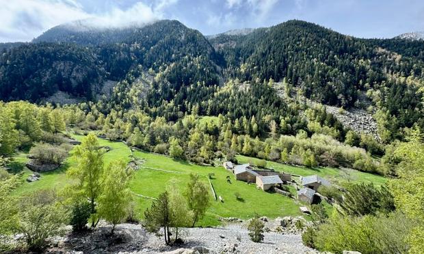
We began at Museo Vostell-Malpartida, founded in 1976 near Malpartida de Cáceres; photography isn’t allowed inside, so we’ve nothing to share/ won’t attempt to describe the art. It’s within Monumento Natural Los Barruecos, given the museum’s buildings were part of a wool processing complex that created that reserve’s artificial ponds, formerly used for wool washing. The surrounding granitic landscape and the new wetland support colonies of Ciconia ciconia | the white stork (📷1); we also got fairly close at ground level (📷2). This hairy fellow is Isturgia famula, a moth native to southern Europe (📷3). This “bujío” is a traditional stone hut used by shepherds for protection from weather or as a temporary resting place (📷4); purportedly a common sight in pastoral landscapes where grazing was historically important.

Aside from storks we identified a variety of birds on the ground, in the water and overhead, including Aegypius monachus | the black vulture; Phalacrocorax carbo | the great cormorant; Hieraaetus pennatus | the booted eagle; Actitis hypoleucos | the common sandpiper; Anser anser | the greylag goose; Podiceps cristatus | the great crested grebe; Ardea cinerea | the grey heron; and Motacilla alba | the pied wagtail. It’s a biodiversity hotspot in an otherwise dry plain!

Charca de Barrueco de Arriba was the second pond we circumnavigated; info boards on the shoreline describe scenes from the “The Spoils of War” episode of Games of Thrones that was shot here (📷1). Safe from attack by fire-breathing dragons, the smaller-scale winged creatures we did see included this black and white beauty, Aporia crataegi | the black-veined white butterfly (📷2). A number of the granite formations have been named, such as Peña del Tiburón | Shark Rock, with natural erosion forming an eye and mouth (📷3); although we didn’t see any sharks in the pond, we did see Mauremys leprosa | the Mediterranean turtle. On the blue trail there are examples of petroglyphs from the Bronze Age, but all we made out was a caged rock. We could see only grass and granite at the site marked as a late Roman village. The “anthropomorphic tombs” were an easier spot, although there was no information on site regarding their age or occupants (📷4); possibly early medieval? Our route blended the green, red and blue trails, covering 8km in under 3h.

Monfragüe National Park

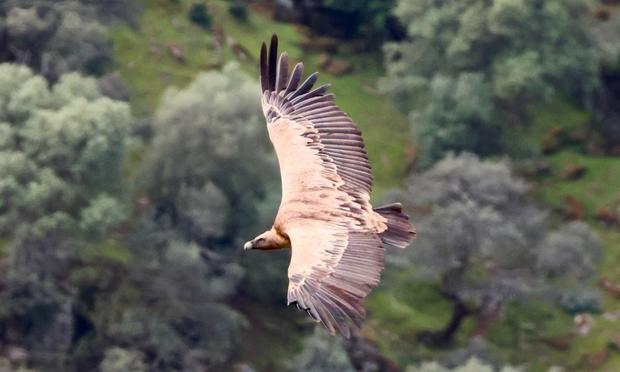
We celebrated Earth Day (as we all should) getting our dose of greens and blues in Parque Nacional de Monfragüe | Monfragüe National Park at the heart of the UNESCO Monfragüe Biosphere Reserve. This park in the Extremadura region is renowned for its birdlife and we had hardly begun our first trail when this small and familiar Fringilla coelebs | chaffinch sang us a fine tune (📷1); you can hear it below. The birds got rapidly bigger and soon we heard the whoosh of air through the flight feathers of Gyps fulvus | the griffin vulture (📷2). The park is also known for its landscapes, including rocky crags, scrubland, rivers and oak woodlands called dehesas in Spain—the montado in Portugal (📷3); this variety supports biodiversity. Gum rockrose were everywhere and on many of the bright white flowers beetles fulfilled a messy pollinator role; meet Heliotaurus ruficollis (📷4).

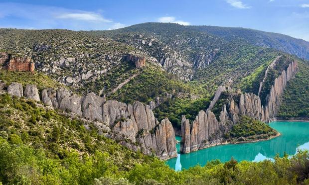
We saw lots of butterflies in Monfragüe National Park—always a healthy sign—including Zerynthia rumina | the Spanish festoon, widespread across Spain (📷1) and Maniola jurtina | the meadow brown, which has a wider range (📷2). We began our second trail by crossing one of the bridges over the Río Tajo (📷3), a natural river by origin but reshaped by human activity including dam building. It was from a lookout of said river (Salto del Gitano) that we caught sight of our first Ciconia nigra | the black stork, recently arrived from sub-Saharan Africa and part of a European migratory population that come to breed here (📷4).

Also at Salto del Gitano we spied—thanks to the line of bird scopes and lenses pointed at it—Monticola solitarius | the blue rock thrush, who appeared to be commenting on the attention being received (📷1). The geology at Salto del Gitano is noteworthy too; the near-vertical quartzite strata of Peña Falcón on the opposite bank shelters one of the most important griffon vulture colonies in Europe (📷2). We continued the trail to the hilltop Hermitage and Castle of Monfragüe, just closing as we arrived—but the free views of the landscape were worth the climb (📷3). As we got back to the van we were overflown by Milvus migrans | the black kite (📷4), a consolation prize for not having seen Aquila adalberti | the Spanish imperial eagle.

Villareal de San Carlos to La Tajadilla, out-and-back was 9km and took a little over 3h. Our Fuente del Francés via Salto del Gitano and the castle return loop was 8km/ 3h.

Toledo (Castilla-La Mancha)

The historic centre of Toledo in Castilla-La Mancha (the plains around which are the stomping grounds of fictional character Don Quixote, first penned in 1605 CE) is a UNESCO-listed World Heritage Site. Situated on a hill above the Río Tajo | Tagus River, the old town’s skyline is dominated by the Alcázar—a fortress with layers of Roman, Moorish and Spanish history, now a military museum (📷1); seen here from Mirador del Valle. Toledo’s listing in part reflects a long history of coexistence between Jewish, Muslim and Christian cultures—thus, references to the “city of three cultures”. In the Judería | Jewish Quarter we visited Sinagoga del Tránsito (1357–1391), converted to a church in 1492 and a museum of Jewish history since 1910 (📷2). There were queues to see the Moorish interior of Synagogue of Santa María la Blanca; also in the vicinity is the Monastery of San Juan de los Reyes, known for its ornate cloisters (but we were feeling out-cloistered by now!). Instead we saw a Moorish exterior, at the former Mosque of Cristo de la Luz (999–1186), said to be one of the best-preserved Islamic structures in the city, despite conversion into a chapel (📷3). Catedral Primada Metropolitana de Santa María de la Asunción, the city’s 13th C. Gothic cathedral features an elaborate interior, including ornate carved “misericords” into which monks would lean backwards in order to remain technically standing during long services (📷4).

Toledo’s UNESCO listing also reflects its concentration of monuments from different periods (Roman, Visigothic, Islamic, Gothic and Renaissance), as well as its roles as a former capital of Spain and an intellectual centre in medieval Europe. Puente de Alcántara is a bridge across the Río Tajo of Roman origin, although the current structure is largely medieval (📷1). Puerta del Sol | the Sun Gate was built by the Knights Hospitaller, a Catholic military order, in the late 13th to early 14th C. and combines Romanesque with Islamic styles (📷2). Both landmarks—the bridge and the gate—seem to typify Toledo’s architectural layer cake, in which the constructs of different periods are superimposed to create something not fully one thing nor the other. As a whole, the intact old town serves as a poignant reminder of the heritage lost to “strategic” bombing during WWII elsewhere in Europe (there was some damage during the Spanish Civil War). While wandering the old town this street corner made us think of the approach to the Treasury in Petra (📷3); even the more modern buildings are commonly sympathetic in style (📷4).

Aranjuez (Madrid)

Palacio Real de Aranjuez | the Royal Palace of Aranjuez is a UNESCO-listed component of the broader Aranjuez Cultural Landscape; this former royal residence lies ~50km south of Madrid. The palace was begun in 1561 CE by Philip II as a seasonal hunting lodge, with two subsequent wings enclosing a parade ground. To our eye the façade looks as if it had been commissioned under a restricted budget (📷1). Entry to the palace gardens is free. As Jardín del Parterre | the Parterre Garden has been demolished pending restoration, that left Jardín de la Isla | the Island Garden, a neglected-looking park consisting almost entirely of trees and hedges; note its fountains are on a timetable (📷2). A ticket buys internal access for a self-guided tour through some of the key royal apartments, the decoration of which largely reflects a mid-19th C. refurbishment under Isabella II. The Arab Study was our favourite, reminiscent of the Alhambra—indeed, it was designed by the man who restored that palace (📷3). Many rooms contained dark paintings with impaling scenes or female wardrobe malfunctions, perhaps gifting the royals some curious dreams. A bright exception was the garish Porcelain Room, a Rococo-style addition in 1763–65 which must have induced many a migraine since (📷4).

Continuing or eastward journey, we exited Extremadura to enter another new-to-us region: Aragón.

#2026 #camperVan #castillaLaMancha #europe #extremadura #hiking #madrid #nationalPark #nature #nomad #roadTrip #romans #spain #travel #unesco #vanLife
Sunday Worship - May 10, 2026

YouTube