Mapping The Land [USGS 3DEP program]
--
https://connectedworld.com/mapping-the-land/ <-- shared technical article
--
#GIS #spatial #mapping #LiDAR #opendata #3DEP #3DHP #elevation #remotesensing #TNM #QL1 #TheNationalMap #USA #NGTOC #3delevation #data #infrastructure #natural #constructed #engineering #publicsafety #planning #model #modeling #urbanplanning #agriculture #economicdevelopment #economicbenefits #coastal #risk #hazard #geology #engineeringgeology #massmovement #USGS
@USGS
--
https://connectedworld.com/mapping-the-land/ <-- shared technical article
--
#GIS #spatial #mapping #LiDAR #opendata #3DEP #3DHP #elevation #remotesensing #TNM #QL1 #TheNationalMap #USA #NGTOC #3delevation #data #infrastructure #natural #constructed #engineering #publicsafety #planning #model #modeling #urbanplanning #agriculture #economicdevelopment #economicbenefits #coastal #risk #hazard #geology #engineeringgeology #massmovement #USGS
@USGS
Mapping the Land - Connected World
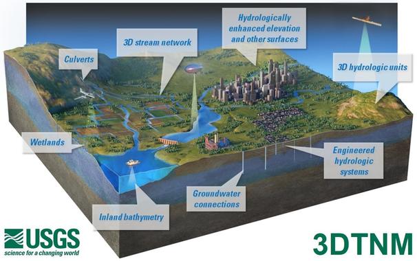
With the passage of the Bipartisan Infrastructure Law, one of the largest and most significant investments in rebuilding our roads and bridges since President Eisenhower’s Interstate Highway System, attention has been paid to updating the maps that will show where construction and long-term investments are most needed. To provide this data, the U.S. Geological Survey LiDAR used for USGS mapping