Peter Puddock and the Puddocky: the thread about Municipal Frogs and Flood-prone Pitches

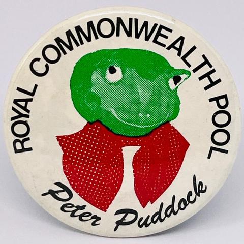
An unexpected – and irresistible – eBay find in recent days was this charming (or, depending on your feelings towards anthropomorphic frogs, terrifying) button badge featuring Peter Puddock, the one-time mascot of Edinburgh’s Royal Commonwealth Pool. Peter was created as a marketing campaign by the District Council in 1987 and his name was chosen by a children’s competition which attracted some three hundred entries.

ROYAL COMMONWEALTH POOL – Peter Puddock

The lucky winner was ten year old Marjorie Drysdale from Prestonfield. In addition to securing the naming rights she was awarded a photo-shoot with Peter, who presented her with two golden passes for a year’s free swimming at The Commie. In addition, from the chairman of the council’s Recreation Committee, she received one of these badges and a matching t-shirt.

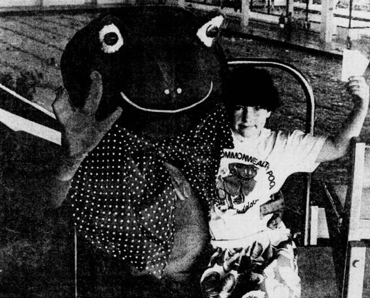
Marjorie and Peter at the Commonwealth Pool, she sporting her t-shirt and holding the prize tickets, he resplendent in his enormous bow tie. Edinburgh Evening News photo, 18th March 1987

Following this, Peter’s first official public outing was at McDonald Road Library on March 21st, the occasion being the sale of 20,000 ex-circulation books. After that, what became of him is not recorded in the pages of the Evening News or any other newspaper. However, in August 2018 the Dartmouth Chronicle reported that a Peter Puddock had accused Kingswear Parish Council of financial mismanagement and running up a £17,000 financial shortfall. Coincidence? Who is to say…

So what’s in a name? As recorded in the Dictionaries of the Scots Language, Puddock is the word for a frog in that leid (or a toad, the two species are often confused). It can also be spelled puddick, poddock or paddock, but does not share an etymology with the English word paddock (from parrock or park), instead having its roots in the Old Norse padda for toad. It may be used as an adjective – puddockie or puddocky – to describe the sort of wet, boggy ground which abounds in amphibians. It has various reduced forms including paddy but it’s pure coincidence that the same word is used in English for a flooded field where rice is grown; in this case that’s a loan from the Malay word pādī.

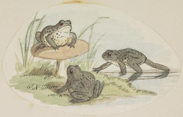
Three Frogs, by Jemima Blackburn (née Wedderburn), mid 19th century. National Gallery of Scotland collection.

Sections of the Water of Leith were once commonly known as the Puddock Burn although by the mid-19th century it was remarked upon that this was a nostalgic notion on account of the river pollution having rendered it almost entirely devoid of such wildlife. This association is also used more specifically for the section of the river between Canonmills Bridge and Powderhall, long known as The Puddocky.

“Water of Leith from Back of Warriston Cemetery”, a romantic scene at The Puddocky in the 19th century – in reality the river here by this time was extremely polluted. Note the steam train running along the railway embankment on the middle right distance. 1850, John Reid Prentice. Credit; Edinburgh Museums and Galleries.

While it’s true that generations of children have fished here for frogs with bits of string and jeelie jars, the name instead derives from an older placename of Paddockhaw or Puddockhall, a farm of that name in this location being recorded in 1724. There was no actual hall here however, the word being referred to is the Scots Haugh; a level plain alongside a river, seasonally wet land prized by farmers and frogs alike.As a place it disappeared after 1763 when the river was significantly straightened in an attempt to deal with flooding, but the name has persisted in to modern times.

Robinson & Fergus 1759 Town Plan of Edinburgh (left, photo © Self) and Kirkwood’s 1817 Town Plan (right, reproduced with the permission of the National Library of Scotland) overlaid on each other, move the slider to compare. This shows the development of the area around this time, in particular the straightening of the Water of Leith that trapped a portion of land belonging to Heriot’s Hospital that was once contiguous with the holding on the north bank of the river on the south instead.

The persistence of the name in collective memory has perhaps been helped by its surprisingly prominent literary profile. In an 1898 biography of Robert Louis Stevenson – educated nearby at the Canonmills school of the Free Kirk – Evelyn Blantyre Simpson relates that on learning the 23rd psalm (“The Lord’s my Shepherd, I’ll not want; he makes me down to lie in pastures green; he leadeth me the quiet waters by“) the boy’s over-active imagination pictured this as being his riverside playground of the Puddocky where he spent many an hour splashing around, attended by his ever-present nursemaid Cummy.

A statue dedicated to Robert Louis Stevenson, depicting him as a boy, located by the Water of Leith at Colinton Parish Church where his grandfather was minister. CC-by-SA 4.0 Rosser1954

The young RLS was not the only Edinburgh author to have formative memories of the place, Muriel Spark recalls in her autobiography Curriculum Vitae that “at weekends we roamed in the botanical gardens or went for walks at Puddocky“. She would use it as a location in The Prime of Miss Jean Brodie where the character Teenie allegedly took a romantic “walk” with her boyfriend which resulted in an unwanted pregnancy. Norman Macaig refers to it in “his most sustained meditation on Edinburgh“, the 1973 poem Inward Bound:

Journeys, Mine were
as wide as the world is
from Puddocky to Stockbridge
minnows splinter in a jar
and a ten-inch yacht
in the roaring forties of Inverleith Pond
crumples like a handkerchief

The Puddocky name also has a number of long-standing associations with sport in the district. Part of Warriston Park was taken on as playing fields by the Edinburgh Institution (later to become Melville College) in the 1860s, with cricket played in the summer and rugby in the winter. This ground was part of the Water of Leith’s flood plain and had once been the site of the ornamental pond of Wester Warriston House. Unsurprisingly as a sports pitch it was perpetually damp, usually waterlogged in winter and more suited to webbed feet. It gained the derisory nickname of The Puddocky. It was taken over later by the Edinburgh School Board in 1910 and remains as playing fields for school use to this day.

Lothian Regional Council hasn’t existed for 30 years, but their sign for Warriston playing fields is nevertheless still in remarkably good condition

On the opposite bank from here was the triangle of land possessed by The Governors of Heriot’s Hospital that had been marooned on that side when the river was straightened out. From 1883 this was used as a football ground by the itinerant St Bernards F.C. but after 1887 it was transferred back to Heriot’s as school playing fields. Again this site was frequently damp and again it found itself nicknamed The Puddocky. The school lasted here for little more than a decade before removing to altogether more commodious and drier facilities further north at Bangholm. Renamed Old Logie Green, it became the ground of Leith Athletic F.C. who played here until 1915. The displaced St Bernards didn’t have too far to go however and moved just next door to the New Logie Green ground.

1894 OS 1:25 inch map of Edinburgh showing the various Puddocky sports grounds. The Institution’s Ground on the left can be seen below Eildon Street, now merged with Warriston Park as the council playing fields. The Heriot’s Ground is on the opposite bank of the river, and wound later be known as Old Logie Green. The ground marked as St Bernard’s Football Ground was New Logie Green. Reproduced with the permission of the National Library of Scotland

Once again the nickname Puddocky was applied for the usual reasons and this site holds a unique claim to fame in that it is the only football ground outside of Glasgow where the Scottish Cup has been held. Owing to a timetabling clash at the usual Hampden Park venue in 1896 the game was played instead at the ground of the holders – St Bernards. The match was an Edinburgh derby, Heart of Midlothian prevailing over their city rivals Hibernian by three goals to one. St Bernards departed here in 1899 when their lease expired and the ground was removed, Logie Green Road driven through its heart.

The 1896 Scottish Cup game, the unique occasion of it being an Edinburgh derby at an Edinburgh ground. On the left is the old house of Logie Green which abuts the pitch and in the background is the roof line of Warriston Crescent. Note the steam locomotive on the railway embankment, which appears to have stopped to spectate. Note also the pitch line markings are different from those we are familiar with these days.

To keep you on your toes if you are trying to research either of these two football teams or either of the two Logie Green grounds, Leith played very briefly at New Logie Green in the 1899 season and St. Bernards returned to Old Logie Green between 1921-24. From then until final closure in 1926 Old Logie Green was home to, you’ve guess it, Leith Athletic. In the century since then it has been the football boots of generations of Edinburgh school children playing soggy winter fixtures at Warriston that have trod on the last remaining Puddocky pitches.

If you have found this useful, informative or amusing, perhaps you would like to help contribute towards the running costs of this site – including keeping it ad-free and my book-buying budget to find further stories to bring you – by supporting me on ko-fi. Or please do just share this post on social media or amongst friends.

These threads © 2017-2026, Andy Arthur.

NO AI TRAINING: Any use of the contents of this website to “train” generative artificial intelligence (AI) technologies to generate text is expressly prohibited. The author reserves all rights to license uses of this work for generative AI training and development of machine learning language models.

#Canonmills #Powderhall #River #RobertLouisStevenson #Sport #SwimmingPool #Warriston #WaterOfLeith #Written2025

Destructor! the thread about Powderhall’s railway and how it dealt with the Victorian city’s rubbish

Now here’s a little story, To tell it is a must
About an unsung hero, That moves away your dust

Lonnie Donegan, “My Old Man’s a Dustman”

Powderhall was one of Edinburgh’s lesser known railway stations. It was only open for 21 years, from 1895 until closure in 1916 as a wartime economy measure (to free up manpower for military recruitment). It was one of a number of less well patronised stations in the city that were closed; some would later reopen after the war, but Powderhall never did.

https://www.flickr.com/photos/127340508@N05/40846647883

The bearded stationmaster standing on the platform above may well be the same man sitting on the bench below.

https://www.flickr.com/photos/127340508@N05/46706543154

The station opened was opened by the North British Railway on April 22nd 1895 on its existing line from Abbeyhill Junction to Granton and North Leith.

Railway Clearing House diagram map of the Edinburgh district, Powderhall is centred and highlighted.

Coming from the direction of Edinburgh, it was immediately preceded by Leith Walk Station and followed by Trinity (on the Granton line) and Bonnington (on the North Leith line). The Evening News described it as the “best that the Company have erected” in the district, with excellently appointed waiting rooms, mirrors and lighting throughout. There were two waiting rooms and waiting would be required as there was only one train per hour, and these only served the Granton line as it was felt Leith Walk and Bonnington were too close to make stopping the trains to Leith there worthwhile. The station master was Mr Bowerbank, “for 19 years inspector at Waverley Station“. The station was accessed from a booking hall that was at the level of Broughton Road, extended out from the bridge that took the carriageway across the tracks.

https://www.flickr.com/photos/127340508@N05/34004075508

The animated transition below shows the above image overlaid on a modern streetscape.

Now-And-Then at Powderhall station.

The photo of the station booking office was probably taken not that long after closure, judging by some of the detail we can see. The place looks a bit abandoned, with a light over the doorway removed or broken? Posters in windows may indicate its closure and the station pinboard appears to be obscured by large posters on which is legible “The Sale of …”.

Powderhall Station booking office and entrance building

A fire here in July 1925 destroyed the roof and interior and it was demolished not long thereafter. The façade was reduced in height at this time to continue to serve as the bridge parapet, so when you pass it you can be forgiven for thinking it was always meant to look that way. Instead, the three central recesses are the former window bays and the lower section on either side the doorways, rebuilt to serve as gateways to the station steps which continue to provide access to the platforms long after closure.

Powderhall Station remains. © Self

In 1930, then owners the London & North Eastern Railway applied for permission to convert the two waiting rooms into domestic houses, which was approved. Each house got a section of garden and had fenced-off access down the former platform via the station steps from Broughton Road. The below photo, which could be any time in the 1950s through to 1950s, shows smoke coming from one of the chimneys, a sure sign of life within.

https://www.flickr.com/photos/127340508@N05/47813042281

https://www.flickr.com/photos/127340508@N05/46377992525

The area name Powderhall comes from a house of that name the Powder Hall, a house and (gun)powder mill set up in the locality around 1695 by the local landowners the Balfours of Pilrig. From the picture below with its wonky window placements and awkward proportions, one gets the idea that it was an older 17th century house that had been progressively altered to try and fit the ideal of a Georgian villa, with mixed success. The house passed later into the Mylne family, the Setons and then Sir John Hunter Blair, grandson of Sir James Hunter Blair.

Powder Hall, from Old & New Edinburgh by James Grant, vol. 3

In the map below, the site of the Railway Station is in Mr. Milne’s ground, just to the left of the house of Rose Bank.

Ainslie’s Town Plan of Edinburgh, 1804. Reproduced with the permission of the National Library of Scotland

In the back of quite a number of the above pictures we can see parts of a Scottish Baronial-style building. This was the ominously named Corporation Destructor! In a time when nearly all household waste was combustible it was mostly burned in the home fireplace; glass and ceramic jars and bottles were returned and reused, and metal cans had recycling value too. Larger or non-combustible items and what to do with partially combusted ash, rotten food and the thousands of tons of horse manure posed a growing problem however. In 1891 the city estimated it had an annual collection of 110,000 tons of refuse. 20,000 tons were classed as “mud or sludge” and were easily disposed of. 61,000 tons were being sent by rail or canal to farms. 7,000 tons were going to parks and gardens in the city and the balance of 22,000 tons was being dumped as landfill in old quarries and ravines. There was an additional problem that the “quality” of the waste was decreasing, household waste was increasingly tarnished with undesirable components and thanks to improved domestic sanitation had far less in the way of “night soil” in it and therefore its market value had collapsed. The city’s receipts for selling its waste in the the decade 1881-90 had decreased by over half from 1871-80. The solution was the destructor, a high-temperature incinerator to treat the waste by combustion.

Illustration of the destructor from the Broughton Road side. From “Refuse destructors : with results up to present time” by T. Tomlinson, 1894

This scheme was highly controversial before it was even built. One local proprietor, writing to the Scotsman labelled it the “Gehenna of Edinburgh” (a valley in the Holy Land where the kings of Juda sacrificed their children in a fire; a destination of the wicked where they atoned for their sins.) The Dean of Guilt Court approved its construction on March 30th 1892 and it was estimated it would cost £16,000.

Illustration of the destructor from Powderhall Grounds to its rear. From “Refuse destructors : with results up to present time” by T. Tomlinson, 1894

The Destructor system was designed by the City Engineer, John Aitken Cooper in consultation with Glasgwegian marine engineer James Howden. In 1882 Howden had patented a forced-draught system for boilers which blew air pre-heated by the boiler’s own hot exhaust gases into the furnace, increasing the rate and consistency of combustion. This was perfect for ensuring thorough “treatment” of the waste being consumed in the furnaces and the higher temperatures resulted in a reduction in empyreumatic gases; the products of imperfect combustion, which resulted in smells, smoke and pollution. There were ten combustion “cells“, each of which had a Horsfall-type furnace and could consume 10 tons of refuse a day, which was fed in through the top from a loading platform (“M. Charging doors in the diagram below). Pollution was further reduced by four “fume cremators”, coke-fired furnaces where a temperature of 800-1000°C was maintained to literally burn the smoke and destroy its empyreumatic components. At the base of the 185ft tall chimney was a cyclone-type dust-catching system.

Plans of the Destructor and Fume Creators employed at Powderhall. From “Refuse destructors : with results up to present time” by T. Tomlinson, 1894

There was space for a 150 ton stockpile on the site. Heat from the processes was used to generate steam, which drove a mill during the day to crush the furnace clinker into a commercially attractive size. At night it provided electric light to allow the work of destruction to carry on 24 hours a day. The baronial-style red sandstone building on Broughton Road was the stables for the twenty resident horses that pulled the city’s scaffie carts, scaffie being the Scots word for a scavenger or street cleaner. It was also designed to screen the offending Destructor plant behind it from the public’s view.

Architect’s elevation of the Destructor’s stable block from 1893.

The Destructor was completed and ready for action up on the 14th August 1893, with Councillor Sloan of the Town Council, who had been instrumental in driving the plans through, having the honour of striking a ceremonial match to light the first furnace. It was estimated it would take the combustion cells an entire month to reach their peak operating rhythm. In practice it was not quite as perfect as it should have been on paper; the 80-100 tons a day promised were in practice more like 50-60 tons and the operating costs were not the promised 10d per ton, but 2/ 8¼d; over three times higher. In 1898 the city was producing 400 tons of refuse per day, so still ended up sending over three quarters of it to landfill in the shale mines of West Lothian around Pumpherston. This latter deficiency was not a failing of the Destructor though, the City Engineer had planned that it would be the first of four for the city, but the others were never provided.

Layout plans of the Powderhall destructor. From “Refuse destructors : with results up to present time” by T. Tomlinson, 1894

The Destructor was closed in 1919 as the plant was life-expired and beyond economical repair, by which time it could only cope with 17% of the city’s refuse output. A new facility was commissioned on the site ten years later in 1929, where waste was first sorted to salvage textiles, paper, glass and metal and the remainder pulverised and compacted for landfill. Incineration was kept to a minimum on site. Ten years later, two similar facilities were provided at Russell Road in Roseburn and at Seafield. All three of these were closed in 1969 as being out of date and too expensive to operate, but particularly because they could not cope with the changes in what society was throwing away. Household fires were less common and therefore so was burning your own rubbish. In addition to this, “disposable” packagings, particularly plastic, were on the increase, as was a boom in consumer goods and a waning of the old fashioned reluctance to throw things away. An entirely new, high-tech and highly automated refuse disposal works was opened in 1971 on the Powderhall Destructor site.

https://www.flickr.com/photos/36844288@N00/51676190461

Here, the Corporation’s scaffie carts brought 600 tons a day of the what the city threw away to be to be sorted and incinerated. In 1980 the facility had to be upgraded to cope with 800 tons per day, with a shredding and baling plant installed to process waste for landfill.

https://www.flickr.com/photos/13460108@N06/16647924016

Here’s a striking aerial photo of the Powderhall incinerator at work, just look at that haze it’s casting over the city (bear in mind there is a primary school and nursery directly over Broughton Road from the plant). And this was the problem.

Aerial photo of the Powderhall Incinerator, early 1980s. NCAP.

By 1986 the incinerator had been shut down due to a public campaign against it and changes in environmental legislation. Burning all kinds of waste in an urban environment came to be seen for what it was – an enormous public health and environmental risk. The chimney and plant were demolished but the rest of the facility remained in operation to process waste for landfill. As 100% of its output was now for landfill, the footprint of the incinerator and the site of the long closed Powderhall Station were turned into a transfer station to load the compacted waste onto railway containers for transport to landfill sites. These trains were known as Binliners and were in operation until 2016 when the Powderhall site closed for the final time and the city’s refuse moved to new recycling, sorting and, in a backward step, incineration facilities at Millerhill.

https://www.flickr.com/photos/127340508@N05/15916430602

The 1971 waste transfer station was demolished, but the stable block of the original destructor remains and is to be converted into workshops and artists studios. The rest of the site has been given over to a housing development, progress on which appears (as of 2024) to have stalled.

If you have found this useful, informative or amusing, perhaps you would like to help contribute towards the running costs of this site – including keeping it ad-free and my book-buying budget to find further stories to bring you – by supporting me on ko-fi. Or please do just share this post on social media or amongst friends.

Explore Threadinburgh by map:

Travelers' Map is loading...
If you see this after your page is loaded completely, leafletJS files are missing.

These threads © 2017-2026, Andy Arthur.

NO AI TRAINING: Any use of the contents of this website to “train” generative artificial intelligence (AI) technologies to generate text is expressly prohibited. The author reserves all rights to license uses of this work for generative AI training and development of machine learning language models.

#Lochend #Logan #Restalrig #StMargaret