Do I have any followers at Yale? I'm hosing a Palestine Open Maps mapathon today (Thursday 23 April). These mapathons are always fascinating, beautiful social events.
I should write a paper about these...
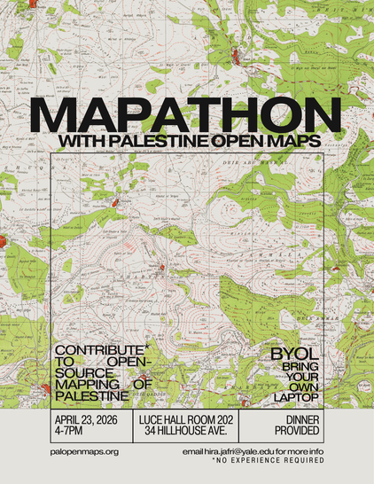
Do I have any followers at Yale? I'm hosing a Palestine Open Maps mapathon today (Thursday 23 April). These mapathons are always fascinating, beautiful social events.
I should write a paper about these...
Palestine Open Maps has been a vital resource for researchers to look closely at archival maps of the region. I've been wanting to set up a recurring donation channel for the project for years, but @bothness and I are so busy with our regular jobs, and the day to day maintenance of the platform, that we haven't had the time to do it.
We are lucky to receive support from Visualizing Palestine for server fees.
Occasionally, hosting organizations for mapathons have a budget to support POM, and that goes to paying for a https://Geocompass.org to make urgent infrastructure upgrades to our platform.
Ahmad has been rewriting the entire front end in Svelte, I've been running mapathons and activating the platform in academic environments and beyond.
I started setting up a page on Open Collective, but I keep running into big legal questions (finding a fiscal sponsor, registering a business and associated bank account, etc...) but it's overwhelming.
RE: https://social.coop/@majdal/116013467936985153
This reminded me that I should publish a list of Palestine Open Maps mapathons that I've run so far. I added the list to my #digitalGarden here: https://majdal.cc/Palestine+Open+Maps+mapathons
36 mapathons and counting!
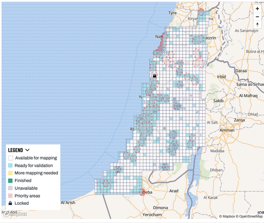
Ran a fun Palestine Open Maps mapathon yesterday with Yara Sa'di-Ibraheem. She's researching communications infrastructure in Palestine during the British colonial era, so we extracted the telecom infrastructure in the historical maps using the Tasking Manager, based on Yara's paper: https://doi.org/10.1016/j.polgeo.2024.103242
We got a lot of work done! Blue squares are the ones that have been worked on. There's a long way to go, but good progress.
#PalOpenMaps #uToronto #OSM #mapathon #OpenHistoricalMap #hotosm

Attached: 1 image This Monday (15 May) will mark 75 years since the Nakba, when over 500 Palestinian communities were forcibly depopulated during the creation of the Israeli state. To mark the occasion, we have re-launched #PalOpenMaps with a bunch of new features https://palopenmaps.org/en/ 1/6
I’m in #Jaffa today, and I’m finally using the new features developed by @bothness for #PalOpenMaps to see where I am on the map.
Of course we see urban growth, but we also see colonisation, ethnic cleansing, and the continuing #Nakba.

A follow up 🧵 on some of the most useful and powerful new features of Palestine Open Maps #PalOpenMaps relevant to #NakbaDay #Nakba #Nakba75
My previous thread can be found here https://vis.social/@bothness/110356522129732527
(Also, read on for a little treat at the end of the thread!)
1/7
Attached: 1 image This Monday (15 May) will mark 75 years since the Nakba, when over 500 Palestinian communities were forcibly depopulated during the creation of the Israeli state. To mark the occasion, we have re-launched #PalOpenMaps with a bunch of new features https://palopenmaps.org/en/ 1/6
