Potential Tropical Cyclone Four just sippin'' a mojita in Cuba at the moment. On the brink of becoming Tropical Depression Debby #PTC4 https://www.nhc.noaa.gov/refresh/graphics_at4+shtml/213131.shtml?cone#contents
POTENTIAL TROPICAL CYCLONE FOUR

Potential Tropical Cyclone #Four satellite picture from today over #Cuba

#PTC4 #weather #WX

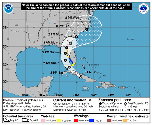
A future Tropical Storm #Debby is forecast to bring heavy rainfall, flash flooding, and storm surge to the west coast of Florida on Monday 🌀⚠️

The system currently tagged as #PTC4 is then forecast to bring impacts to Georgia and the Carolinas through the middle of next week.

This animation shows forecasted wind gusts from the ICON model, which aligns well with the latest NHC forecast:

POTENTIAL TROPICAL CYCLONE FOUR

Sunrise on Potential Tropical Cyclone #Four over #Cuba

#PTC4 #weather #WX

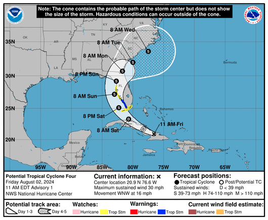
Potential Tropical Cyclone Four #PTC4 has been designated over #Cuba.

Real-time tracker here: https://zoom.earth/storms/04l-2024/

Potential Tropical Cyclone 04L LIVE Tracker, Updates & Forecast | Zoom Earth

Live tracking map, satellite images and forecasts of Potential Tropical Cyclone 04L 2024 over Cuba. Current wind speed 30mph. Max 65mph.

Zoom Earth
Potential Tropical Cyclone 4 #PTC4 (was invest 97L) for Atlantic system - Watches, cone map, etc. coming from NHC shortly as we are closer in time to Tropical Storm impacts arriving over land. (PTC designation let’s that impact potential be known before a storm officially forms) 2Aug2024 #FLwx