I can see why people in #lockyervalley knock down signs of candidates in #elections2024 - 14% informal votes (very high, normally about 5%) - they don't care - tough as boots out in country
#lockyervalley #election2024 many candidate signs are being knocked down and stolen because locals don't value elections and think they are boring and a waste of time instead of a gift of #democracy - I hope they get a good council despite the apathy and aggression of locals #politics #education is needed to teach people to value elections
David Wrigley candidate already has opposition knocking down his signs alongside road for Lockyer Valley Regional Council local government #election - #politics can be dirty #Queensland #lockyervalley #corruption
David Wrigley is running for Lockyer Valley Regional Council in local government #elections in Queensland on 16 March 2024 #lockyervalley #queensland #candidate https://facebook.com/friends/?profile_id=61556501066268 #politics #rural #government #local #australia #davidwrigley #LGA
Just refreshed…
Severe Thunderstorm Warning - Southeast Queensland
for #GiantHailstones, #DamagingWinds and #HeavyRainfall
For people in #Ipswich, #ScenicRim and parts of #Logan, #Somerset, #SouthernDowns, #Toowoomba, #LockyerValley, #GoldCoast and #BrisbaneCity Council Areas.
The Bureau of Meteorology warns that, at 7:50 pm, a VERY DANGEROUS THUNDERSTORM likely to produce large, possibly giant hailstones, damaging winds and heavy rainfall that may lead to flash flooding was detected near Laravale and Kooralbyn. This thunderstorm is moving towards the east. It is forecast to affect the #McPhersonRange and the area south of #Canungra by 8:20 pm and #Beaudesert, Little Nerang Dam and Canungra by 8:50 pm.
Other severe thunderstorms likely to produce damaging winds, large hailstones and heavy rainfall that may lead to flash flooding were detected near Laidley, Gatton and the area northeast of Warwick. These thunderstorms are moving towards the east. They are forecast to affect Rosewood, Hatton Vale and Marburg by 8:20 pm and Ipswich, Boonah and the area between Boonah and Beaudesert by 8:50 pm.
IIIINCOMING!!! #BNEStorm in under a few hours I suspect.
http://www.bom.gov.au/products/IDQ21035.shtml
Severe Thunderstorm Warning - Southeast Queensland
for #DamagingWinds, #LargeHailstones and #HeavyRainfall
For people in parts of #Ipswich, #Somerset, #ScenicRim, #SouthernDowns, #WesternDowns, #Toowoomba and #LockyerValley Council Areas.
The Bureau of Meteorology warns that, at 6:55 pm, severe thunderstorms likely to produce damaging winds, large hailstones and heavy rainfall that may lead to flash flooding were detected near #Dalby, the area northeast of Dalby, #MoogerahDam and #Ellangowan. These thunderstorms are moving towards the east to southeast. They are forecast to affect #Warwick, #Toowoomba and #CrowsNest by 7:25 pm and #Laidley, #Gatton and #Esk by 7:55 pm.
93 km/h wind gust at Dalby at 6:31pm.
96 km/h wind gust at #Oakey at 6:52pm.
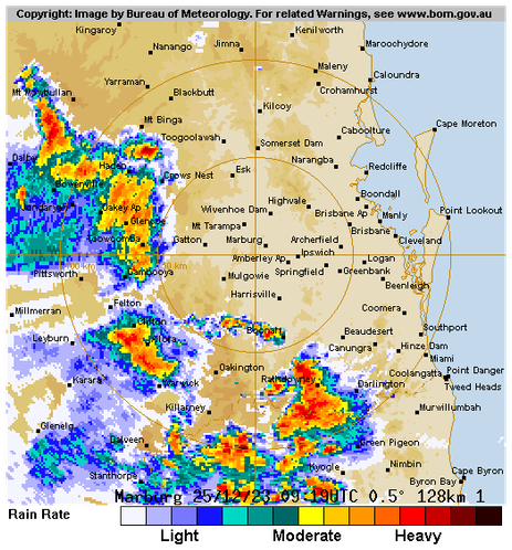
#Esk is about to get smacked. #BNEStorm
http://www.bom.gov.au/products/IDQ21035.shtml
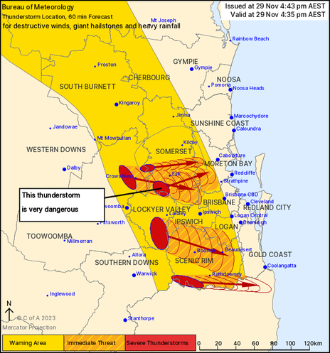
Severe Thunderstorm Warning - Southeast Queensland
for DESTRUCTIVE WINDS, GIANT HAILSTONES and HEAVY RAINFALL
For people in #ScenicRim and parts of #Ipswich, #Logan, #Somerset, #Toowoomba, #LockyerValley, #GoldCoast, #Brisbane City, #MoretonBay and #SouthernDowns Council Areas.
Issued at 4:43 pm Wednesday, 29 November 2023.
VERY DANGEROUS THUNDERSTORM SOUTH OF ESK WITH GIANT HAIL.
The Bureau of Meteorology warns that, at 4:35 pm, very dangerous thunderstorms were detected on the weather radar near the area southwest of Esk.
These thunderstorms are moving towards the east.
Very dangerous thunderstorms are forecast to affect Esk, the area south of Esk and northern Lake Wivenhoe by 5:05 pm and the D'Aguilar Ranges, Lake Samsonvale and Dayboro by 5:35 pm.
Other severe thunderstorms were detected on the weather radar near Mount Barney, Haden, the area west of Toogoolawah and the area northwest of Cunninghams Gap.
They are forecast to affect Boonah, the area northwest of Esk and Crows Nest by 5:05 pm and Beaudesert, the area between Boonah and Beaudesert and Lake Somerset by 5:35 pm.
Damaging, locally destructive winds, large, possibly giant hailstones and heavy rainfall that may lead to flash flooding are likely.