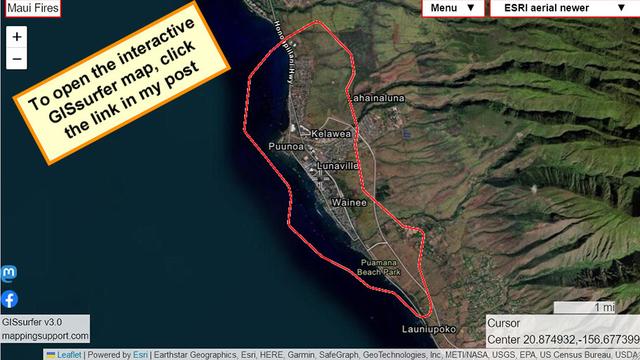
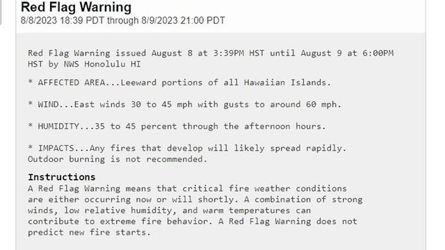
#RedFlagWarning for much of #Hawaii. For official details from NOAA, open the map, click any red area.

Note! Some areas have more than 1 type of watch or warning. So when the popup opens you might need to scroll down to find the link for the red flag warning details.
#HIwx #HIfire

Open #GISsurfer map:
https://mappingsupport.com/p2/gissurfer.php?center=20.566144,-157.576904&zoom=7&basemap=USA_basemap&overlay=State_boundary,Weather_watch_warning&data=https://mappingsupport.com/p2/special_maps/disaster/USA_weather.txt

GISsurfer General Purpose Web Map and GIS Viewer | Surf GIS DATA

GISsurfer lets you surf a nearly endless amount of GIS data. Click a layer in the GIS server's table of contents and that data appears on the map.

GISsurfer General Purpose Web Map and GIS Viewer | Surf GIS DATA

GISsurfer lets you surf a nearly endless amount of GIS data. Click a layer in the GIS server's table of contents and that data appears on the map.

RT Laurie Garrett
Oh my god...
<div class="rsshub-quote">
The Hotshot Wake Up: Unreal moments in Lahaina, Hawaii on the island of Maui.
We cover this on todays episode, below.
#wildfire #hifire
</div>

🐦🔗: https://n.respublicae.eu/Laurie_Garrett/status/1689377175030439936

Laurie Garrett (@Laurie_Garrett)

Oh my god...

Nitter

#RedFlagWarning for Hawaii extended until Thursday morning. For details open the interactive #GIS map, zoom in and click a red area.

Some areas have more than one type of weather warning. So when the popup appears you might need to scroll down to the section with the red flag warning - then follow the link for the details.
#HIfire #HIwx #MauiFire #WestMaui #Lahaina #Wildfire #Geospatial #Maps #Mapping #Leaflet #ArcGIS #WebMap

Open #GISsurfer map:
https://mappingsupport.com/p2/gissurfer.php?center=20.710651,-157.741699&zoom=7&basemap=USA_basemap&overlay=VIIRS_7_day,MODIS_7_day,State_boundary,Red_flag_warning&data=https://mappingsupport.com/p2/special_maps/disaster/USA_wildland_fire.txt

GISsurfer General Purpose Web Map and GIS Viewer | Surf GIS DATA

GISsurfer lets you surf a nearly endless amount of GIS data. Click a layer in the GIS server's table of contents and that data appears on the map.

To read the ‘fire weather forecast’ for #Maui, open this interactive #GIS map, click on Maui and follow the link. Upper and lower part of map has different forecast zones. East to northeast wind with increasing gust speed.

The map has lots of fire related layers you can turn on/off. Click “Map tips” in the upper left corner for help.

#HIfire #HIwx #MauiFire #WestMaui #Lahaina #Geospatial #Maps #Mapping #Leaflet #ArcGIS #WebMap

Open #GISsurfer map:
https://mappingsupport.com/p2/gissurfer.php?center=20.788470,-156.423340&zoom=13&basemap=ESRI_aerial_newer&overlay=USA_roads,MODIS_7_day,VIIRS_7_day,NOAA_fire_weather_forecast&data=https://mappingsupport.com/p2/special_maps/disaster/USA_wildland_fire.txt

GISsurfer General Purpose Web Map and GIS Viewer | Surf GIS DATA

GISsurfer lets you surf a nearly endless amount of GIS data. Click a layer in the GIS server's table of contents and that data appears on the map.

Interactive #GIS map always shows latest MODIS and VIIRS satellite heat detections for fires on #Maui including #LahainaFire and #UpcountryFire. Dark red is a detection within prior 6 hours.

Note the ‘false positive’ data - the ocean is not on fire.

#RedFlagWarning today.

To get the most benefit from the map see 2 links upper left corner.

#HIfire #HIwx #MauiFire #WestMaui #Lahaina #Geospatial #Maps #Mapping #Leaflet #ArcGIS #WebMap

Open #GISsurfer map:
https://mappingsupport.com/p2/gissurfer.php?center=20.878936,-156.678085&zoom=13&basemap=ESRI_aerial_newer&overlay=State_boundary,Forecast_discussion,USA_roads,MODIS_7_day,VIIRS_7_day&data=https://mappingsupport.com/p2/special_maps/disaster/USA_wildland_fire.txt

GISsurfer General Purpose Web Map and GIS Viewer | Surf GIS DATA

GISsurfer lets you surf a nearly endless amount of GIS data. Click a layer in the GIS server's table of contents and that data appears on the map.

August 9 early morning. Interactive #GIS map for fires on #Maui including #LahainaFire and #UpcountryFire.

#RedFlagWarning today.

Map shows various satellite *heat* detections. This data is not real time, locations are only approximate and sometimes ‘false positive’.

To get the most benefit from the map see 2 links upper left corner.

#HIfire #HIwx #MauiFire #WestMaui #Lahaina #Geospatial #Maps #Mapping #Leaflet #ArcGIS #WebMap

Open #GISsurfer map:
https://mappingsupport.com/p2/gissurfer.php?center=20.854599,-156.476898&zoom=11&basemap=USA_basemap&overlay=VIIRS_7_day,MODIS_7_day,State_boundary,Forecast_discussion,GOES_west_fire_enhanced,Red_flag_warning&data=https://mappingsupport.com/p2/special_maps/disaster/USA_wildland_fire.txt

GISsurfer General Purpose Web Map and GIS Viewer | Surf GIS DATA

GISsurfer lets you surf a nearly endless amount of GIS data. Click a layer in the GIS server's table of contents and that data appears on the map.