Here my first #vibecoded experimental project: #ArtenTracker (species tracker). My goal is to make #biodiversity data stored in scientific databases better accessible. Data is from #gbif. With this #prototype I want to find out whether pursuing this project further is promising. Feedback is very welcome. Disclaimer: I am not a professional coder but a biologist. https://huggingface.co/spaces/Sueamit/ArtenTracker

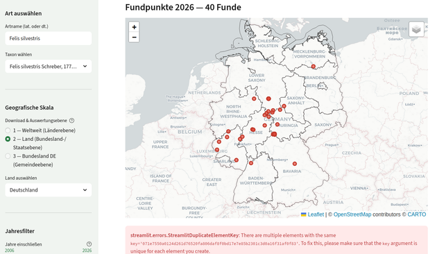
First shot: some results after two long evenings using #claudecode. Here you see distribution data of the #wildcat Felis sylvestris based on #gbif data. This is a webapp. Its an interesting experience to use claude. To get some results seems easy. But to get something that is really robust, valid and useful, still takes lots of effort.
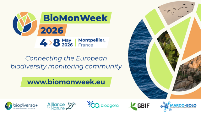
Why #BioMonWeek26?
Biodiversity monitoring in Europe connects the community to collaborate and drive impact. #BioMonWeek offers a space to exchange ideas and align on key challenges.
ℹ️ www.biomonweek.eu
@BiodiversaPlus #AllianceForNature #BioAgora #GBIF #MarcoBolo
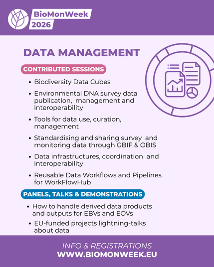
🔦 Spotlight on the Data Management and Mass Monitoring themes at #BioMonWeek26!
Submit an abstract by 18 March and bring your work to the European stage! Explore the full programme:🔗 www.biomonweek.eu
@BiodiversaPlus, #AllianceforNature, #bioagora, #gbif, #marcobolo
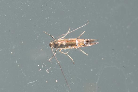
Surprisingly, a springtail expert on iNaturalist has suggested a species ID for this springtail. I wasn't expecting it to be able to be identified to that detail, but it certainly matches the description. It looks like it's *Bourletiella arvalis*.
That makes the springtail a lot more interesting than the moth it's on.
The Global Biodiversity Information Facility (#GBIF) has 334 observations of the moth species (178 of which are from iNaturalist).
GBIF has only 16 observations of this springtail species from New Zealand. If confirmed, my little hitch-hiker here will be the 17th.
→ GBIF Geocoder: using GBIF to find places on a map
https://iphylo.blogspot.com/2026/02/gbif-geocoder-using-gbif-to-find-places.html
“The idea behind the "GBIF Geocoder" is that GBIF has a huge number of geocoded specimens, and hence if you are looking for coordinates for a locality there is a good chance that somebody has already found them. So, all we need to do is search GBIF for specimens with localities that match the place you are trying to geocode.”

@JorisMeys use #GBIF species occurrence point-data (@gbif ). Also spatial, and combinable: https://geodaten.bayern.de
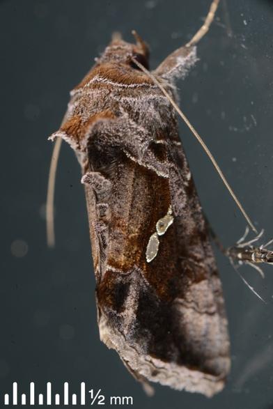
Introducing *Austramathes coelacantha*!
I uploaded this moth to iNaturalist from my moth lighting last month in the NZ mountains. It's now the first iNat record of this NZ endemic moth, which was first described as a species in 2017.
This adds to the five records of the species on GBIF from the NZ Arthropod Collection (four specimens from 1975 and one from 2023).
It's known (so far) from shrublands and beech forests of central and eastern South Island. Its caterpillars have not been confirmed yet, although they're expected to be on *Melicytus* (mahoe and relatives).
Big thanks go to NZ moth expert Neville Hudson for identifying this. Neville has so far made 171,359(!) species identifications on iNaturalist, almost all moths, and all done for free. It's an extraordinary contribution to our knowledge of NZ moths.
https://inaturalist.nz/observations/338636198
#mothodon #moths #Lepidoptera #nz #iNaturalist #iNaturalistNZ #GBIF #entomology #CitizenScience
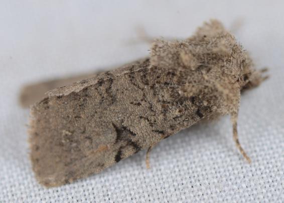
Here's another of the six new moth species to my garden this year, in Ōtautahi-Christchurch, NZ. This one had me puzzled until NZ moth expert Neville Hduson from Auckland identified it this morning on #iNaturalist.
It's the Australian Wattle Gall Miner, *Polysoma eumetalla*, and this is the third record of it on #GBIF from the South Island.
It's a pretty wee thing but easily overlooked because it's tiny (see the second photo of it next to a green garden looper moth).
Remarkably, its caterpillars make their living mining inside galls on some Australian wattle trees, which in NZ are formed by the Australian rust fungus *Uromycladium tepperianum*.
#mothodon #moths #Lepidoptera #nz #entomology #insects #iNaturalistNZ
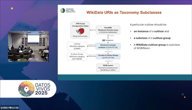
在 Living Data 2025 中有一場 Wikidata 專題演講:【#Wikimedia 與生物多樣性資料:在開放知識生態系中的互惠關係】,議程中探討了 Wikimedia 各專案(#Wikipedia、 #Wikidata 、 #Commons)與全球生物多樣性基礎建設(如 #GBIF、#iNaturalist、Biodiversity Heritage Library/#BHL)之間的交會點,並強調它們在資料動員、標準化、公共參與與知識傳播上的協同作用。
此外,同時討論了 Wikimedia 的社群特性如何協助串連標本資料、文獻以及多媒體資源,朝向建立一個鏈結式(Linked)的生物多樣性知識圖譜。
該議程提供一個討論空間,希望聚焦於生物多樣性資料如何與 Wikimedia 平台連結,確保生物多樣性知識能以開放、結構化、且易於研究者、政策制定者與大眾取得的方式呈現。
議程演講已經公開歡迎至 YouTube 觀看:https://youtu.be/wXaHJ85g88A