Measured in cm, mapped in meters, oops. Hopefully it'll render okay tomorrow. #f4map #OpenStreetMap #3dmapping

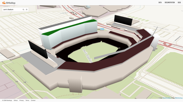
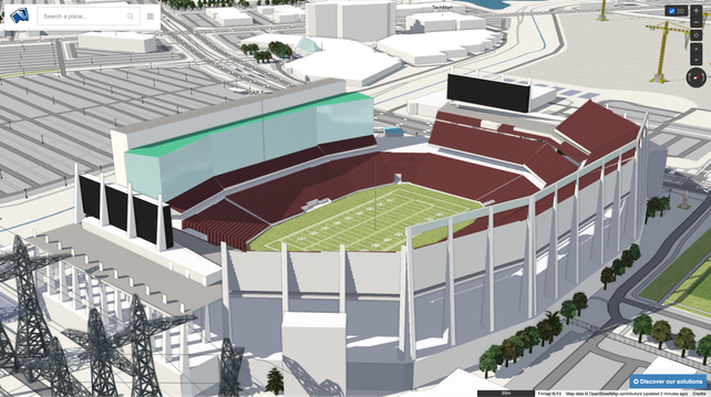
Whew, that was just outdated data. The stadium looks less stuffy in other 3D renderers like #OSMBuildings and #F4Map 😌
https://osmbuildings.org/?lat=37.40313&lon=-121.96990&zoom=18.4&rotation=-73&tilt=44
https://demo.f4map.com/#lat=37.4032380&lon=-121.9702759&zoom=19&camera.theta=69.351&camera.phi=68.755
Cooles Gimmick in der #F4Map : alle Statuen wurden durch verkleidete Kürbisse ersetzt.

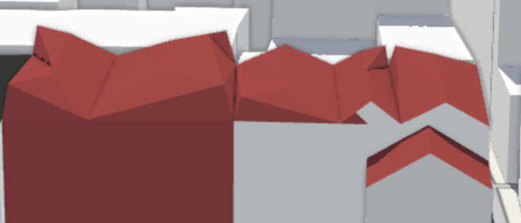
What means roof:direction=E ? Really East? #OSM2World "snaps" to the next wall angle. (pic 2) #F4map produces a bit of a disaster (pic1)
We should try to make an own rendere, "like F4" but better. And we try. (pic3/4) A lot to code, a lot to analyse and describe, how to make #OpenStreetMap tagging to a 3D view.
Would you like to help? Just Testing? Documentation?
Do you code #Bevy #BevyEngine? Do you know #GPU coding? UI design? #wasm ?


Meine liebsten OpenStreetMap-Angebote
* #Mapy - fast wie Google Maps (mit Kommentare, Routen, Umgebung) https://mapy.com/de/zakladni?source=osm&id=11945282&x=9.9698595&y=53.4611790&z=19
* #uMap - eigene interaktive Karten: super https://umap.openstreetmap.de
* #F4map - 3D is teinfach cool https://demo.f4map.com/#lat=53.5411920&lon=9.9856098&zoom=18
* #MapComplete (POIs) https://mapcomplete.org
* POI-Karte (Filter links!) https://www.flosm.org/de/POI-Karte.html?lat=53.4624300&lon=9.97572439&r=1352.9117
* #Wanderer (Spazieren) https://trails.magdeburg.jetzt/map?lat=53.550341&lon=10.000654&tl_lat=53.796000230890115&tl_lon=10.604031966978994&br_lat=53.28209555774936&br_lon=9.413455372160684
* #OpenRailwayMap https://www.openrailwaymap.org/
#OSM #OpenStreetMap #GoogleMaps -Alternativen

Popular map portal covering whole world by wide range of maps - basic, outdoor (hiking/cycling), traffic, winter. It offers possibility of aerial and 3D view. Extensive amount of travel points of interest. Users are able to search places, plan routes, measure ground and create and share own content. Tourists worldwide use map portal for detailed hiking and cycling maps and extensive tourist guides.
www.F4map.org is puzzled? I was checking my new project with it and got odd renderings. in #F4Map there is an option "F4 specific buildings" to show GLB files instead of OSM tagging 3D buildings. But in the case of #Westmister, there is no GLB available, the OSM tagging is quite good. Only in F4 the rendere seems to freak out. You often see a good rendering. (My tool seems to have wrong wall colours) Often you see only parts of the 3D area.
Some of the #OSM tagging is not well defined in all details. So I indented to always check F4, what it does to mimic it. But well, software is never free of errors.


If anyone has been in #Berlin one is probably familiar with the "Berlin Holocaust memorial". A fellow mapper took the time to map out all concrete blocks.
The only thing that needs to be updated is the height, since most of them are 4m which is wrong.
IRL image: https://commons.wikimedia.org/wiki/File:Berlin_Holocaust_memorial,_21_May_2005.jpg


